

Fresh Snow for Monday Morning
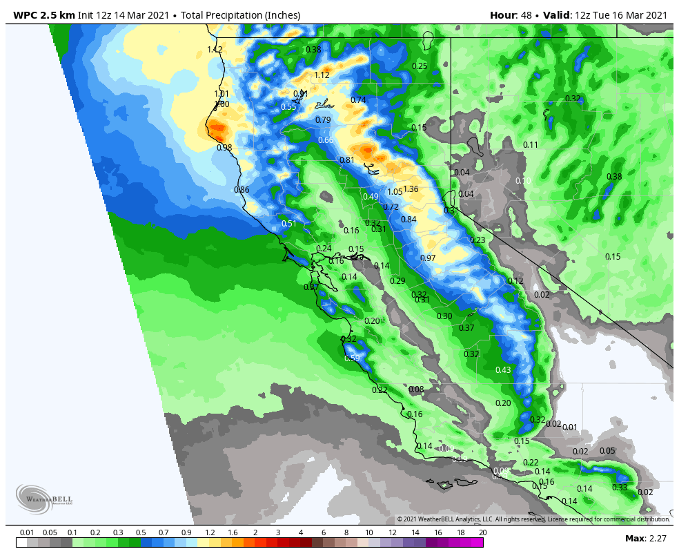
Sunday: Sunday we will see increasing clouds & winds through the day as the next storm approaches the region. Strong ridgetop winds may hold off until just after the mountain closes. Sunday Night – Monday System: Snow from the next storm will move in between 6-10 PM Sunday evening. Then a period of heavier snow […]
2 Feet & Counting
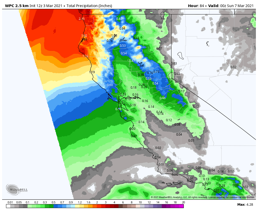
Snowfall Report: Additional snow showers on Wednesday dropped an additional 2-4 inches on the mountain, bringing the 3-day storm total to 25 inches so far on the upper mountain. The season total is now at 263 inches. Thursday Snow Showers: The snow showers diminished Wednesday night into Thursday morning. Low pressure slowly making its way through […]
11 Inches Already, More Snow thru Thursday!
Snowfall Report: A band of heavier snow moved in over the mountain overnight bringing more snow than expected. The mountain is reporting 6-7 inches at the base and 9-11 inches on the upper mountain in the past 24 hours! Tuesday – Thursday Storm: Low pressure will slowly make its way down the CA coast with […]
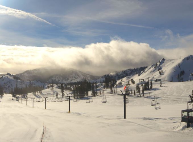
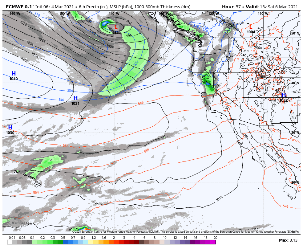
Shred Report // March 6, 2021

The Snowledge crew headed up to Alpine Meadows on Saturday to enjoy the refresh of pow from Friday night’s small system. These guys are always ready to hike to the corners of the mountain to make the most of conditions. Here’s hoping this was just an appetizer of what’s to come this week! Our fingers […]
3 Inches of Fresh Snow, More Snow Monday – Wednesday
Snowfall Report: The fast-moving system that moved through during the early morning hours dropped 3 inches of new snow on the mountain. Saturday – Sunday: Clearing with mostly sunny skies by late morning through the afternoon. Highs only into the 30s. Ridgetop winds still gusting to 70+ mph Saturday morning causing some upper mountain lift […]
Snow Friday Night, More Snow Next Week
Thursday – Friday: Mostly sunny Thu-Fri. Highs warming into the 40s on the upper mountain and near 50 degrees at the base. Ridgetop winds should be lighter through Thursday. Then we could see gusty winds Friday as the next system approaches, with ridgetop winds from the south gusting 50-60+ mph by afternoon. Friday Night – […]
Light Snow Friday Night
Wednesday – Friday: Clouds and sun Wednesday, then mostly sunny Thu-Fri. Highs warming into the 40s on the upper mountain and near 50 degrees at the base. Ridgetop winds should be lighter through Thursday. Then we could see gusty winds Friday as the next system approaches, with ridgetop winds from the south gusting 50-60+ mph […]
Breezy & Cold Saturday, Dry & Milder thru Friday
The Weekend: Saturday we will see mostly sunny skies with colder air in place. Highs in the 30s. Winds turning northerly and gusting 40-50+ mph up top during the afternoon. Mostly sunny skies again for Sunday with highs warming back into the 40s at the base and 30s on the upper mountain. Lighter east winds. […]
Dry & Breezy Thru Sunday
Thursday – Sunday: Mostly sunny and warming back into the 40s Thursday into Friday. Breezy with west winds of 40-50+ mph over the ridges later Thursday and 30-40+ mph Friday. Saturday we have a dry cold front moving through with mostly sunny skies continuing. Highs dropping into the 30s. Winds turning northerly and gusting 40-50+ […]
A Drier Pattern This Week
Sunday – Thursday: For Sunday, we will have mostly sunny skies and lighter winds, with highs warming into the 40s for the lower mountain and 30s up top. The dry weather pattern continues through Thursday with mostly sunny skies expected. Highs in the 40s Monday to near 50 degrees at the base. Highs in the […]