Skip to content
Palisades Tahoe Logo Palisades Tahoe Logo Palisades Tahoe Logo
Explore
Main Menu
  • Explore Palisades Tahoe
  • Base to Base Gondola
  • Our New Name
  • Explore Legendary Lifts
  • Palisades Tahoe Blog
  • About Lake Tahoe
  • About Us
Plan Your Visit
Main Menu
  • Tickets & Passes
  • Lodging
  • Lessons & Guides
  • Deals & Packages
  • Rentals & Demos
  • Travel Here
  • Getting Around
Mountain Information
Main Menu
  • Snow and Weather
  • Lift and Grooming Status
  • Webcams
  • Hours of Operation
  • Trail Maps
  • Parking & Road Conditions
  • Snowfall Tracker
Events & Activities
Main Menu
  • Events Calendar
  • Activities
  • Dining & Apres
  • Shopping
  • Things To Do In Lake Tahoe
  • Groups, Meetings & Weddings
  • Ski & Snowboard Teams
IKON PASS HOLDER LODGING DISCOUNT

Ikon Pass holders save up to 20% on slopeside lodging at The Village at Palisades Tahoe.

SLOPESIDE LODGING
Icon / FlashCreated with Sketch.
View All Offers
  • Weather

11 Inches Already, More Snow thru Thursday!

  • Mar 9, 2021
  • 8:50 am

Snowfall Report:

A band of heavier snow moved in over the mountain overnight bringing more snow than expected. The mountain is reporting 6-7 inches at the base and 9-11 inches on the upper mountain in the past 24 hours!

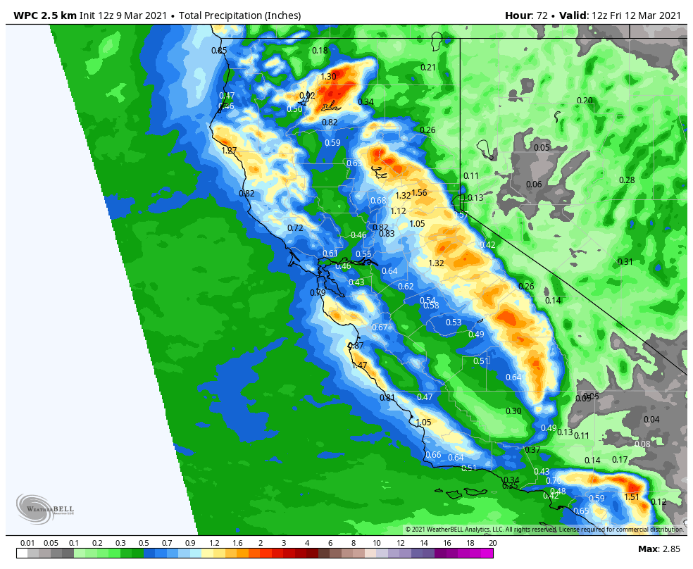
Tuesday – Thursday Storm:

Low pressure will slowly make its way down the CA coast with snow showers possible through Thursday before clearing out Thursday night. This is a cold system with highs only in the 30s through Thursday at the base and 20s up top. The winds should be lighter for Tuesday – Thursday but still gusting 30-40+ mph up top. We could see a bit of a lull in the snow showers Tuesday morning and then returning Tuesday afternoon with an additional 1-2 inches of snow possible by Tuesday evening.

Tuesday night into Wednesday morning we could see a period of heavier snow as we see precipitation push in on the east side of the low as it moves south past the Tahoe Basin. It will be cold Tuesday night with very low snow levels & high snow ratios with powdery snow. That could help to fluff the snowfall with 5-8 inches of additional snowfall possible on the mountain by Wednesday morning, and another 1-3 inches possible Wednesday.

Scattered snow showers with some peeks of sun are possible Wednesday afternoon through Thursday before we clear out Thursday night. A final 1-2 inches of snow is possible. Additional snowfall totals by Friday morning could be 6-11 inches at the base and 9-15 inches on the upper mountain on top of the snow that fell Monday night. That could mean storm totals of 18-24 inches on the upper mountain.

The Weekend:

We have high-pressure building in Friday into Saturday with mostly sunny skies and warming temperatures. Highs into the 40s at the base and 30s on the upper mountain. That weather could continue into Sunday, but a cold trough could begin to move in by Sunday night with some gusty winds and light snow showers possible.

Long-Range:

The colder air and snow showers could continue next Monday. Then we may be drier through the end of next week as high pressure builds back in.

The next chance for active weather looks like it could be around the end of the 3rd week of March into the last week of the month. We will be keeping an eye on that.

BA

lake tahoe weather snowfall forecast Squaw Weather Forecast
Bryan Allegretto
Bryan Allegretto

Share this article:

Recent Posts

  • Weather ·
  • March 29, 2023·

Partly Sunny Wed-Sun w/ Snow Showers Possible

Snowfall Reports: 12 inches of new snow fell on the mountain in the past 24 hours as of 5 AM…
Read more
  • Weather ·
  • March 28, 2023·

Snow & Strong Winds Tuesday

Tuesday  – Wednesday Storm: Snow showers are pushing in Tuesday morning, with heavier snow expected later in the morning into…
Read more
  • Weather ·
  • March 27, 2023·

Snowstorm Tuesday, Snow Showers Wed-Sun

Monday: Monday will start out sunny with highs in the 30s at the base and 20s up top. Some high…
Read more

Social

Instagram Twitter Facebook Youtube

Contact

   Email Us
   1.800.403.0206

Our Partners

U.S. Forest Service Logo
1960 Olympic Valley Road
Olympic Valley, CA 96146

©2022 Palisades Tahoe

Alterra Mountain Company
  • Privacy Policy
  • Terms of Service
  • Photo Upload Terms of Use
  • Accessibility
  • Do Not Sell My Personal Information
  • Privacy Policy
  • Terms of Service
  • Photo Upload Terms of Use
  • Accessibility
  • Do Not Sell My Personal Information