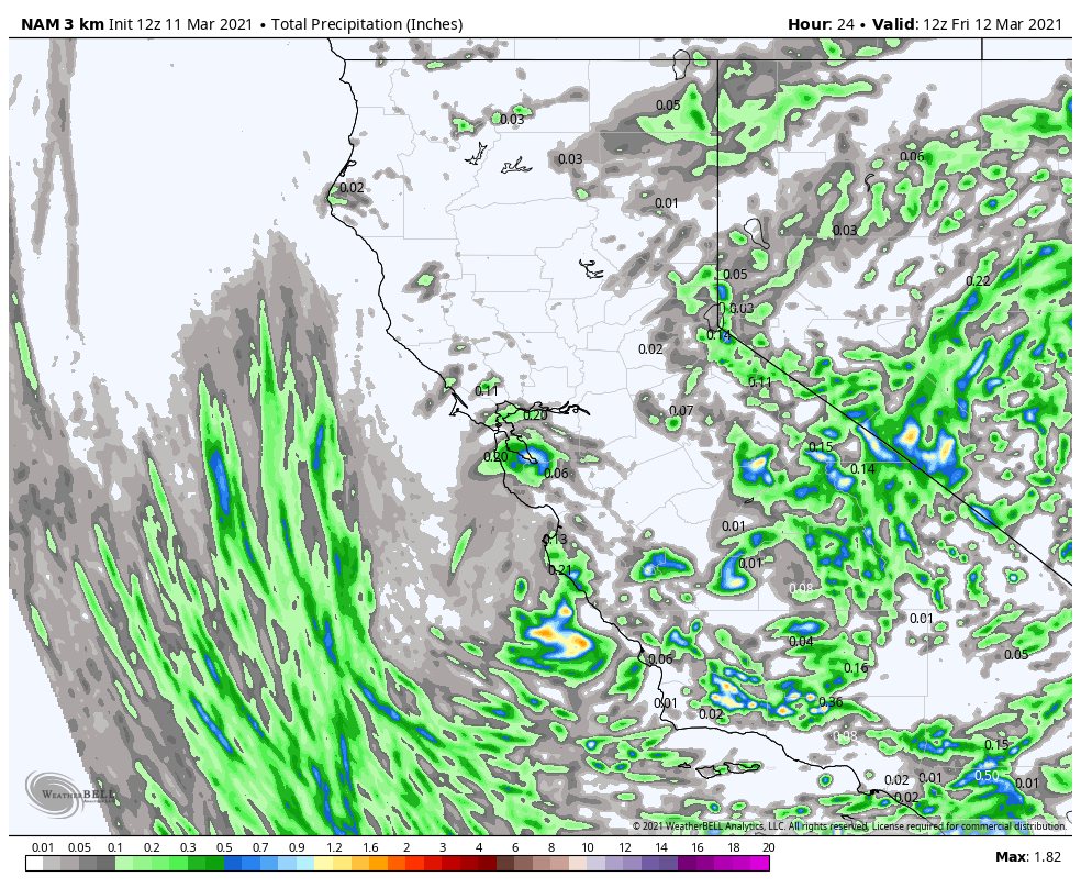
Skip to content
Palisades Tahoe Logo Palisades Tahoe Logo Palisades Tahoe Logo
Explore
Main Menu
  • Explore Palisades Tahoe
  • Base to Base Gondola
  • Our New Name
  • Explore Legendary Lifts
  • Palisades Tahoe Blog
  • About Lake Tahoe
Plan Your Visit
Main Menu
  • Tickets & Passes
  • Lodging
  • Lessons & Guides
  • Deals & Packages
  • Rentals & Demos
  • Travel Here
  • Getting Around
Mountain Information
Main Menu
  • Snow and Weather
  • Lift and Grooming Status
  • Webcams
  • Hours of Operation
  • Trail Maps
  • Parking & Road Conditions
  • Snowfall Tracker
Events & Activities
Main Menu
  • Events Calendar
  • Aerial Tram
  • Activities
  • Dining & Apres
  • Shopping
  • Groups, Meetings & Weddings
  • Ski & Snowboard Teams
Winter Lodging Exteriors of the Village at Palisades Tahoe
Book Winter Early

Ikon Pass holders save up to 25% when you book with The Village at Palisades Tahoe this winter.

SAVE ON LODGING
Icon / FlashCreated with Sketch.
View All Offers
  • Weather

2 Feet & Counting

  • Mar 11, 2021
  • 8:30 am

Snowfall Report:

Additional snow showers on Wednesday dropped an additional 2-4 inches on the mountain, bringing the 3-day storm total to 25 inches so far on the upper mountain. The season total is now at 263 inches.

Snowboarder Audrey Herbert slashing snow at Alpine Meadows on a powder day
Audrey Herbert slashing snow at Alpine Meadows March 10, 2021. Photo: Ryan Salm

Thursday Snow Showers:

The snow showers diminished Wednesday night into Thursday morning. Low pressure slowly making its way through southern CA and moisture moving in from the east on the north side of the circulation will bring back scattered snow showers by Thursday afternoon into Thursday night before clearing out Friday. Highs in the 30s at the base and 20s up top. 

We could see an additional dusting up to 2 inches of snow by Friday morning. Any heavier cells of convective snow showers could bring a bit more if one forms over the mountain. There is also a small chance for thunder & lightning around the region. Any nearby would close the lifts until it clears the area.

The Weekend:

High pressure builds in over CA Friday into Saturday with mostly sunny skies and warming temperatures. Highs into the 40s at the base and 30s on the upper mountain.

Sunday should start out with similar weather but we could see increasing clouds & winds later in the day as the next storm approaches the region.

Sunday Night – Monday System:

For Sunday night into Monday, we are tracking the next storm. The forecast models vary on the timing of the arrival with some bringing snow back to the mountain by Sunday evening and others holding off until Monday morning. They also disagree if we just see a dusting snow as the system falls apart, or if it will hold together bringing several inches of new snow.

We will continue to watch the trends and update the forecast. Snow levels start out around 5000-5500 ft. Sunday night and fall below 4000 ft. by Monday morning. Ridgetop winds could be gusting 50-60+ mph by Sunday night but come back down Monday. Using the average of the models this morning, by Monday afternoon we could see 1-3 inches of snow at the base and 1-4 inches on the upper mountain.

Long-Range:

We may see another break Tuesday into next Wednesday. We may be right on the edge of the storm track when storms return later next week. That means the forecast could go either way, dry/wet. We will be watching closely and will let you know as we get closer.

BA

lake tahoe weather snowfall forecast Squaw Weather Forecast
Bryan Allegretto
Bryan Allegretto

Share this article:

Recent Posts

  • Weather ·
  • September 19, 2023·
The predicted El Nino pattern for this winter

2023-24 Palisades Tahoe Winter Forecast Preview…

As we look ahead to the 2023-2024 winter season, it's important to remember that any winter outlook will contain an inherent degree of uncertainty. However, there are a few clues that we can keep an eye on.
Read more
  • Weather ·
  • May 8, 2023·

Final Forecast of the 2022-23 Season

First Week of May Snowfall Report: The first week of May was a cold and snowy one. The upper mountain…
Read more
  • Weather ·
  • May 1, 2023·

Snowy First Week of May

Monday – Friday Snow Shower Chances: A low-pressure system will be making its way south down the coast on Monday…
Read more

Social

Instagram Twitter Facebook Youtube

Contact

   Email Us
   1.800.403.0206

Our Partners

U.S. Forest Service Logo
1960 Olympic Valley Road
Olympic Valley, CA 96146

©2022 Palisades Tahoe

Alterra Mountain Company
  • Privacy Policy
  • Terms of Service
  • Photo Upload Terms of Use
  • Accessibility
  • Do Not Sell My Personal Information
  • Privacy Policy
  • Terms of Service
  • Photo Upload Terms of Use
  • Accessibility
  • Do Not Sell My Personal Information