Skip to content
Palisades Tahoe Logo Palisades Tahoe Logo Palisades Tahoe Logo
Explore
Main Menu
  • Explore Palisades Tahoe
  • Base to Base Gondola
  • Our New Name
  • Explore Legendary Lifts
  • Palisades Tahoe Blog
  • About Lake Tahoe
  • About Us
Plan Your Visit
Main Menu
  • Tickets & Passes
  • Lodging
  • Lessons & Guides
  • Deals & Packages
  • Rentals & Demos
  • Travel Here
  • Getting Around
Mountain Information
Main Menu
  • Snow and Weather
  • Lift and Grooming Status
  • Webcams
  • Hours of Operation
  • Trail Maps
  • Parking & Road Conditions
  • Snowfall Tracker
Events & Activities
Main Menu
  • Events Calendar
  • Activities
  • Dining & Apres
  • Shopping
  • Things To Do In Lake Tahoe
  • Groups, Meetings & Weddings
  • Ski & Snowboard Teams
IKON PASS HOLDER LODGING DISCOUNT

Ikon Pass holders save up to 20% on slopeside lodging at The Village at Palisades Tahoe.

SLOPESIDE LODGING
Icon / FlashCreated with Sketch.
View All Offers
  • Weather

Snow Friday Night, More Snow Next Week

  • Mar 4, 2021
  • 8:36 am

Thursday – Friday:

Mostly sunny Thu-Fri. Highs warming into the 40s on the upper mountain and near 50 degrees at the base.

Ridgetop winds should be lighter through Thursday. Then we could see gusty winds Friday as the next system approaches, with ridgetop winds from the south gusting 50-60+ mph by afternoon.

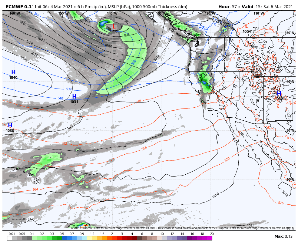
Friday Night – Saturday System:

Friday night into Saturday morning the next system moves into northern California and the Sierra. We may see light snow move in around midnight and lasting into Saturday morning. Then clearing by late morning with the sun coming out through the afternoon. Highs only into the 30s. Ridgetop winds could still be gusting to 70+ mph Saturday morning causing some upper mountain lift delays, but coming down through the day.

Snow levels starting out below the base and falling. That will bring drier snow on the mountain. We could see 2-4 inches of fresh snow at the base and 2-5 inches on the mountain by mid-morning Saturday.

Sunday:

Sunday we should see mostly sunny skies with highs in the 30s on the upper mountain and 40s at the base, with lighter winds.

Monday Storm:

Increasing clouds and winds Monday with snow showers possible by late morning. Ridgetop winds could increase to 70-80+ mph during the afternoon closing some upper mountain lifts. Highs only in the 30s. 

The snow should pick up in intensity later in the day into Monday night, with snow showers lingering into Tuesday morning. This is a cold storm Monday night that could have high snow ratios with powdery snow. Initial snowfall estimates by Tuesday morning are for 5-8 inches at the base and 7-11 inches on the upper mountain.

Long-Range:

The active pattern may continue through next week. The next system may move into the CA coast later Tuesday into Wednesday with more snow. Another system is possible next Thursday – Friday.

It looks like a colder and active week. None of the storms look really big, but if see several storms next week the snow could start to add up. We will continue to track these systems as we get closer with more details as they become clearer.

BA

lake tahoe weather snowfall forecast Squaw Weather Forecast
Bryan Allegretto
Bryan Allegretto

Share this article:

Recent Posts

  • Weather ·
  • March 21, 2023·

Weak Systems & Snow Showers thru Sunday

Tuesday Storm: The next storm pushes snow showers back in by later Tuesday morning, with steadier snow through Tuesday afternoon.…
Read more
  • Weather ·
  • March 20, 2023·

More Weak Systems Tuesday-Friday

Snowfall Reports: No real surprises with the weak storm that moved through on Sunday. We were expecting 3-11 inches from…
Read more
  • Weather ·
  • March 19, 2023·

Two More Storms Sun & Tue

Sunday Storm: Snow showers are moving in Sunday morning, and will continue through the day before becoming more scattered Sunday…
Read more

Social

Instagram Twitter Facebook Youtube

Contact

   Email Us
   1.800.403.0206

Our Partners

U.S. Forest Service Logo
1960 Olympic Valley Road
Olympic Valley, CA 96146

©2022 Palisades Tahoe

Alterra Mountain Company
  • Privacy Policy
  • Terms of Service
  • Photo Upload Terms of Use
  • Accessibility
  • Do Not Sell My Personal Information
  • Privacy Policy
  • Terms of Service
  • Photo Upload Terms of Use
  • Accessibility
  • Do Not Sell My Personal Information