

Snowfall Report:
The convective snow showers over-delivered on Friday as we thought they might. We picked up 8 inches of new snow in the past 24 hours at the base as of 6 AM Saturday, and 15 inches on the upper mountain. That brings the final 3-day storm total to 23 inches! That’s around 5 inches over what we expected from the storm thanks to a heavy band of snow over the mountain Friday evening.
Saturday Weather:
It’s a beautiful morning as the sun is coming out and the winds have dropped off behind the storm. Temperatures are only in the teens this morning. We will have some sun, a few clouds, maybe a few scattered snow showers, along with cold temperatures. Highs in the 20s on the mountain and 30s at the base. The winds are on the lighter side as well.
Saturday Night – Monday Night Storm:
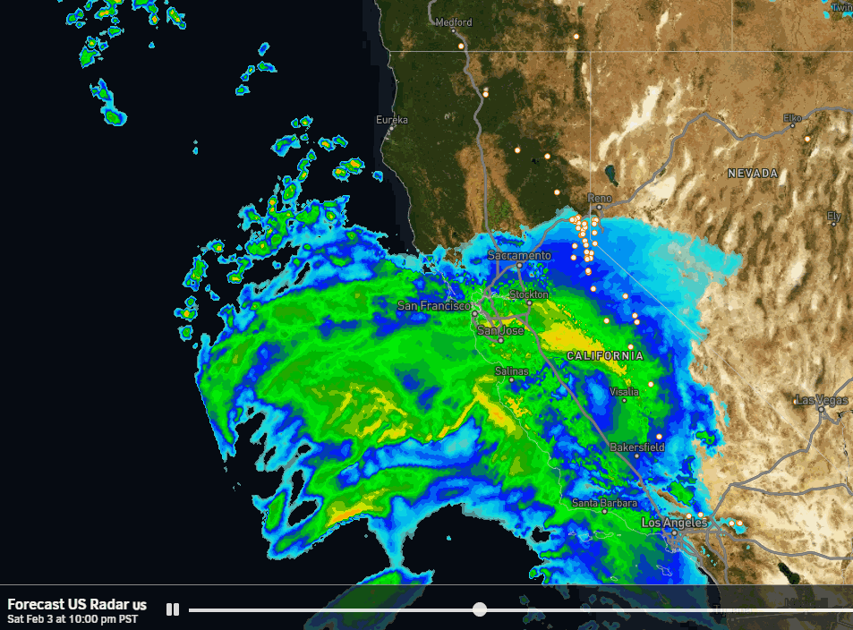
The main event is approaching and will bring us the biggest storm of the year! The latest model runs show some lighter snow showers moving in Saturday evening from the south, and then the steadier snow moving in around midnight and becoming heavier into Sunday morning. Steady snow continues Sunday night into Monday, with snow showers Monday night as the storm winds down.
The winds will come up on Sunday with ridgetop gusts up to 60-70+ mph from the south-southwest. That will likely close some upper mountain lifts. The winds will still be gusty Monday morning but are forecast to drop through the day. If there are some wind holds in the morning, I would expect those to drop during the day opening up the upper mountain to the fresh and deep snow! Highs in the 20s on the upper mountain and 30s at the base.
Snow levels will start low Saturday night, well below the base, with the cold air in place ahead of the warm AR that will point at us Sunday. The temperatures will rise on Sunday and the snow levels will try to reach the base. But the latest model runs still show snow levels peaking out right around 6000 ft. due to the very heavy snowfall rates, so we should stay all snow at the base.
Then the snow levels drop Sunday night as colder air works into the storm. The snow ratios could average around 10-16:1 from the base up to 9000 ft. That means some higher-density snow for the lower elevations and some lighter-density snow above 8000 ft. which means some fun skiing!
Those snow ratios combined with 3-4 inches of liquid means a BIG dump of snow coming for the Sierra! This will be my final forecast for the storm and we will tally up the 3-day totals again on Tuesday morning. Overall 2-3 feet of snow is expected at the base and 3-4+ feet on the mountain by Tuesday morning!
Tuesday – Friday:
We could see some scattered snow showers lingering on Tuesday along with some sun and lighter winds. HIghs into the 30s for the lower elevations and 20s for the upper elevations. Similar temperatures on Wednesday but maybe a bit more sun as it could be the driest day of the week.
We are watching the next system forecast to drop into the Sierra Thursday into Friday. The latest model runs show a weak-moderate storm that could drop several more inches of snow! I’ll start to look at the potential snowfall details on Sunday. Overall an unsettled week ahead through Friday.
Long-Range Forecast:
The long-range models continue to show high pressure starting to build in over the West Coast next weekend and continuing through mid-month into the 3rd week of February. That could keep us dry and slightly milder into President’s Weekend. But the pattern is trying to change by the eighteenth with storms trying to push into the West Coast again beyond that.
Initially, the storms may weaken or split with stubborn high pressure over the West, but eventually, the long-range models suggest that storms will have more success in pushing into the Sierra, with a wetter period possible around the 19th-25th.
We’ll continue to watch the trends closely to see when storms could return later in the month. In the meantime, we have a lot of snow piling up to bring great conditions to ski through the next dry period!
BA
