The Weather through Thursday:
Mostly sunny days through Thursday as high pressure continues to dominate our northern CA weather pattern. Highs into the 50s for the lower elevations and 40s for the higher elevations. Lighter winds into Wednesday, with some increased breezes Wednesday afternoon into Thursday.
Weekend Storm:
We will have a shift back to winter as we go into spring starting on Friday. Friday will be the transition day with increasing winds and clouds. Highs drop into the 40s. We could see some rain showers reach the mountain by afternoon. Ridgetop winds gusting up to 60-70+ mph by the end of the day.
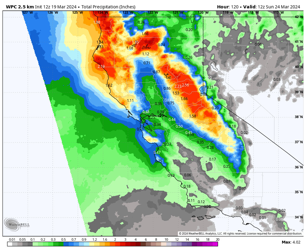
The heaviest precipitation moves through Friday night with the passage of the cold front. Then snow showers for Saturday, becoming more scattered into Sunday before the storm clears out Sunday night. Highs in the 30s, with 20s on the peaks. Ridgetop winds gusting up to 50-60+ mph Saturday and dropping off into Sunday.
The snow levels will start high Friday afternoon into the evening, up around 7000-8000 ft. Then falling quickly overnight as the cold front moves through. By Saturday morning snow levels could be around 4000-4500 ft, well below the base, and staying below the base through the end of the storm.
We start with rain for the lower elevations and low snow ratios Friday night, then increase snow ratios through Saturday night. Above 7000 ft. the snow ratios could average around 10-15:1, with the driest snow up above 8500 ft. By Sunday morning we could see snowfall totals around 7-12 inches at the base, 13-18 inches near mid-mountain, and 16-22 inches up top.
Only light snowfall amounts are expected on Sunday as the storm winds down. It should be a good day for fresh tracks as the winds drop as well.
Long-Range Forecast:
The test between the models seems to be resolved over the past 24 hours as both the European and the European AI models have trended toward the GFS model’s forecast for troughs and an open storm door to continue through the last week of March.
Temperatures will remain below average through the period. The next weak system could move through with more snow on Monday. We could see a break next Tuesday the 26th. Then a wetter storm is possible by Wednesday night into Thursday the 28th. A final storm is possible around the 29th – 30th.
If the forecasts hold, we could have 4 or so storms headed our way with a shot of snow with each through the last week of March. Winter is coming back in time for spring. Hopefully, we have a few more powder days in our future before the end of March!
April:
The ensemble mean models are still in fairly good agreement that the pattern begins to shift by the end of the month into the first week of April. The trough shifts east and high pressure builds in the eastern Pacific near the West Coast.
That should bump the storm track to our north with a drier pattern setting in. That is common going into April with the best chance for good snow usually from slow-moving cut-off lows. We’ll continue to watch the long-range through April to see if we will get any late-season fresh tracks.
BA