Thursday – Friday Weather:
We have a calm day for Thursday with partly sunny skies and highs into the 40s. Friday we could see partly sunny-mostly cloudy skies with highs in the 40s.
Friday Night – Saturday Night:
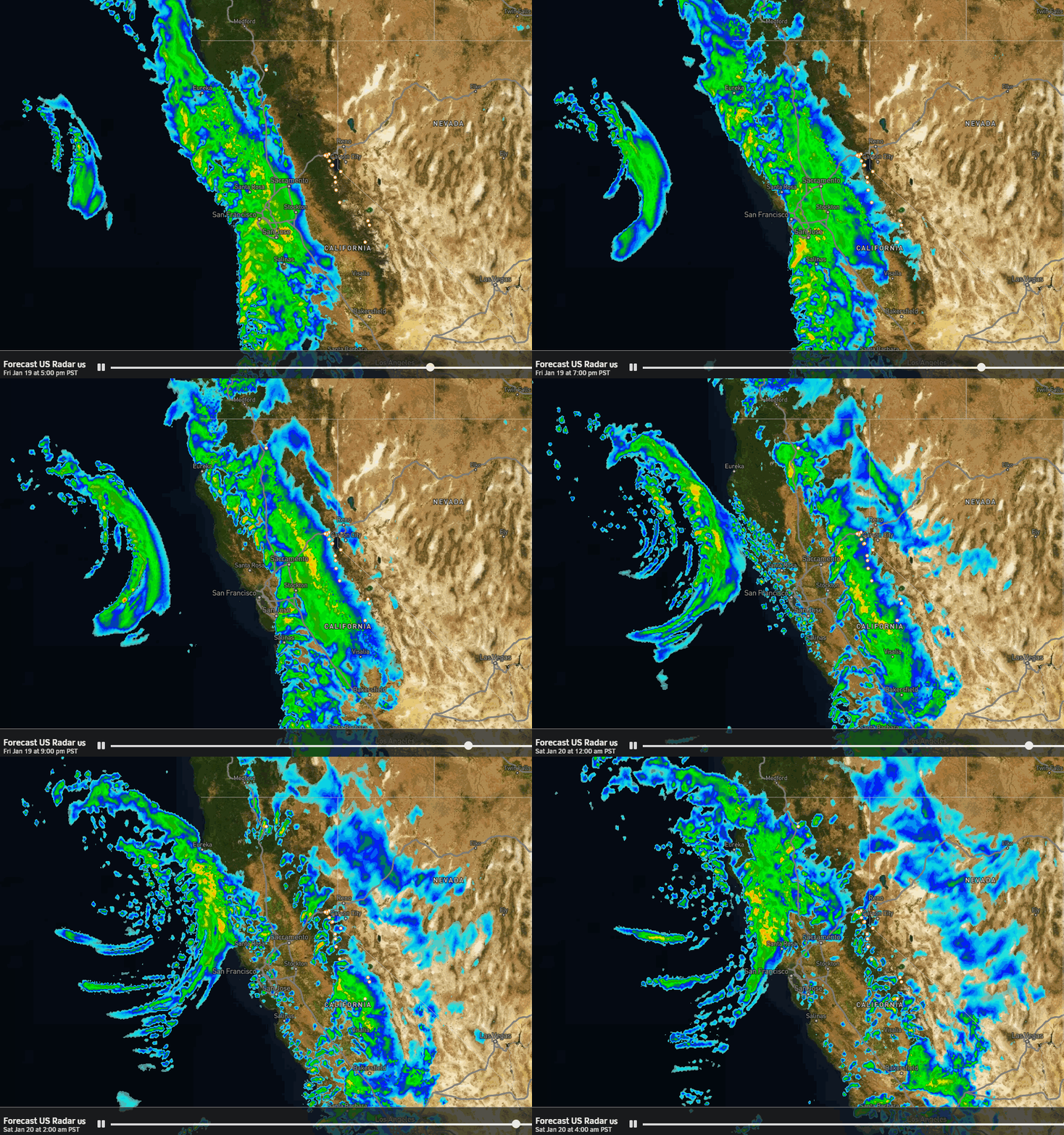
Rain & snow showers will start to push into the northern Sierra between 7-10 PM Friday night. The latest model runs now show the center of the low associated with the first system digging a bit farther south toward northern CA Saturday into Saturday night. That may turn the winds more southwesterly with some stronger gusts up to 50-60+ mph over the ridges.
That could also help to bring in slightly more precipitation and better forcing and mountain orographics, and slightly colder air. The latest model runs have trended up their precipitation forecasts today.
They are also slightly colder. They have snow levels starting around 7000-7500 ft., but quickly falling to near the base for the rest of the storm through Saturday night, hovering in the 6000-6700 ft. range, and then dropping near 5500-6000 ft. by early Sunday morning. We could still see some rain mixing in at the base, but it looks like we could see mostly all snow above 6500 ft., and definitely all snow above 7000 ft.
Due to the increase in the precipitation forecasts and decrease in the temperature forecasts, the snowfall forecast has gone up for the upper mountain. We could see 4-8 inches at the base with some rain possibly mixing in and decreasing that, and 5-12 inches on the mountain from 7k’ up to the peaks.
Sunday – Monday:
The second half of the 3-day storms series starts Sunday and ends Monday night. We could see a moist onshore flow Sunday with lighter showers and lighter winds, along with snow levels rising up to around 6500-7000 ft. Not expecting more than a coating up to 2 inches of new snow on the mountain during the day.
Sunday night into Monday a wetter and warmer storm is still forecast to move through. Some models end the showers by Monday evening with a few lingering showers into Monday night before ending overnight. The models are slightly wetter today for this storm as well.
The snow levels could fluctuate between 6000-7000 ft. through Sunday night, with heavy bands of precip trying to drag them down near the base. Monday snow levels could peak around 6800-7300 ft., and then fall to around 6000-6500 ft. by the end Monday night.
That means most of the snow at the base is expected to fall at the start Sunday morning and at the end Monday night, with rain and a mix in the middle of the storm. Expecting mostly snow above 7k, and likely all snow above 7500 ft. We could see 1-4 inches in total near the base and 8-16 inches above 7k’ by early Tuesday morning.
3-Day Totals:
Snowfall is hard to forecast when snow levels are fluctuating throughout a storm series, especially below the snow line. In total Saturday – Monday we could see around 5-12 inches of snow at the base, but with rain squashing that down. Above 7000 ft. we could see 13-28 inches, with the amounts jumping the higher in elevation you go up the mountain where it’s colder and all snow.
Tuesday – Wednesday:
It looks like we could see a break in the storms Tuesday, with a final weak system possibly brushing us on the southern edge Wednesday, as high pressure starts to build in over CA pushing the storm track farther north. Highs in the 30s on the mountain to near 40 degrees at the base.
Long-Range Forecast:
By next Thursday through the end of January, we still expect to see high pressure over the region with a drier and milder pattern for the last 7 days of the month. Mild Pacific air will be flowing into the West bringing a big change in the temperatures from the frigid air seen over the last two weeks. Back to the mild pattern we saw earlier in the season.
The long-range models are trying to extend the Pacific jet stream toward the West Coast again during the 1st week of February with lower heights near the West Coast and the storm door possibly reopening for CA at some point during the 1st week of February.
That could bring us back to a similar pattern as this weekend and back during the last week of December. That is what I call getting snow the hard way, as the storms tend to be milder, and they can also weaken or split by the time they reach the Sierra.
We’ll continue to watch the trends…
BA


