Wednesday – Thursday:
Mostly sunny skies through Thursday. Highs into the 30s for the upper mountain and 40s at the base. Lighter winds are expected through Thursday.
Friday Night – Saturday System:
We will see increasing winds ahead of the system on Friday with ridgetop gusts up to 60-70+ mph from the southwest, which could affect some upper mountain lifts. Increasing clouds as well through the afternoon. Highs are still in the 30s for the upper mountain and 40s at the base.
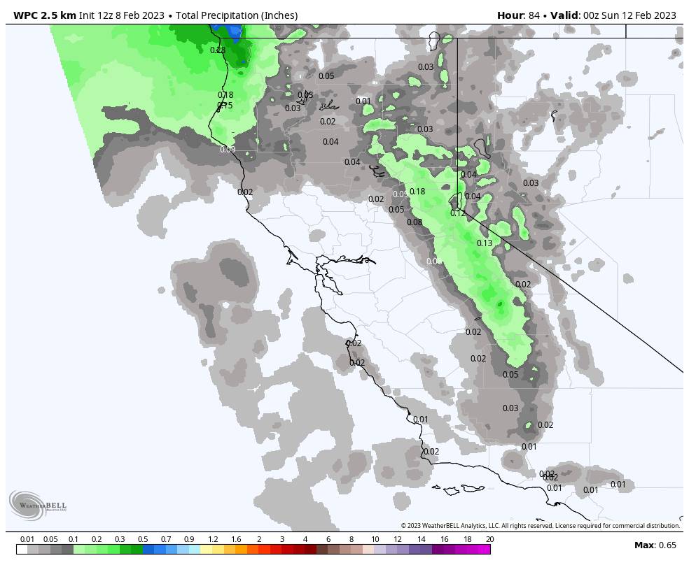
Snow showers could reach the Sierra around 8-10 PM Friday evening, and then possibly continue into Saturday morning before clearing out later in the day. The forecast models are struggling with where a band of steadier snow sets up on the east side of the low as it moves north to south through central CA, and with how much snow could fall.
We could see gusty northeast winds set up for Saturday as well, with ridgetop gusts up to 40-50+ mph. That could affect some exposed upper mountain lifts again. Highs in the 20s up top and 30s at the base.
Here is my updated snowfall forecast for potential snowfall totals by Sunday morning. I had to increase the range due to some models showing barely any snow and others setting up a heavier band over the mountain.
- 1-6 inches at the base.
- 2-7 inches at mid-mountain elevations.
- 2-8 inches up top.
We’ll continue to watch the trends and fine-tune the forecast as best as we can over the next few days.
Sunday:
For Sunday we clear out with colder temperatures behind the storm. Mostly sunny skies and highs into the 30s. We could continue to see gusty northeast winds up to 40-50+ mph up top, which will make it feel even colder through the weekend.
Mild Monday:
High pressure is over CA Monday with mostly sunny skies and highs warming into the 40s.
Tuesday – Wednesday Cold Front:
The long-range models show the next cold trough digging south into CA by Tuesday bringing colder air into the region into Wednesday. We could see some snow showers with the front Tuesday, and then partly-mostly sunny skies for next Wednesday the 15th. Much colder with highs into the 20s Tuesday, and then into the 30s at the base by Wednesday.
Long Range:
That cold trough could shift east later next week with the dry pattern continuing and the highs warming back into the 40s by the end of the week.
President’s Weekend into the last week of February the long-range models show a broad trough setting up over the West. But they don’t agree with the placement of the trough.
Some models have the trough far enough West into CA that we could see weak/moderate systems dropping down from the north-northwest, while others have eth trough farther east with northern CA getting brushed by storms or completely dry.
We’ll continue to watch the trends to see how the pattern may set up later in the month. As of right now, we don’t see any significant storms on the horizon, just weak systems with light snow. We’ll let you know as soon as we see something more significant.
BA