Snowfall Totals,
A final 3 inches of snow fell on the upper mountain Monday. That brought the 4-day storm total to 17 inches up top, and only around 4 inches of wet snow at the base.
Tuesday Weather:
Partly-mostly sunny skies for Tuesday with highs in the 30s. It looks to be a beautiful day!
Wednesday System:
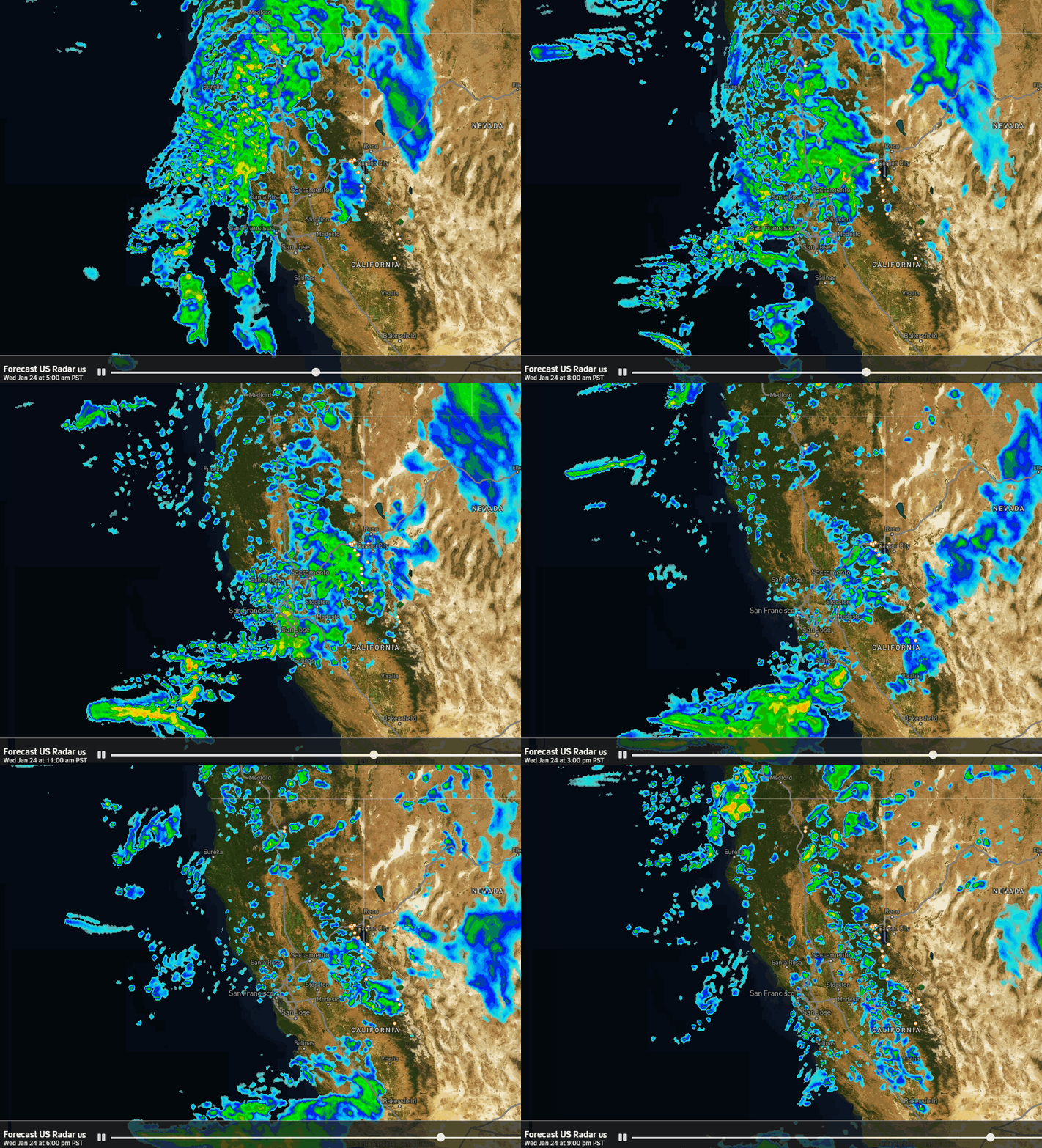
The next weak and mild system moves in early Wednesday around 4-7 AM, with rain and snow showers continuing into Wednesday night before clearing out by Thursday morning. Highs in the 30s. Ridgetop winds from the west increasing with gusts up to 50-60+ mph by afternoon. That could affect a few upper mountain ski lifts.
Snow levels could start out near the base early Wednesday morning as the showers move in with drier air in place. Then they rise through the day and could be up around 6500-7000 ft. by afternoon, and even up near 7500 ft. under any very light drizzle and mist, similar to the last 4 days. Then dropping to around 5500 ft. by the end later Wednesday night.
That means another weak and mild system with most of the snow falling on the upper mountain. With the models coming in a bit wetter this morning my snowfall forecast increased by about an inch on the high end. We could see a dusting up to 3 inches of wet snow at the base and 2-5 inches of snow on the upper mountain by early Thursday morning.
Thursday Weather:
Thursday should be similar to Tuesday with partly-mostly sunny skies, highs in the 30s, and lighter winds. You may want to get out to enjoy the sun before we could see rain going into the weekend.
Friday – Saturday Rain Showers:
The latest model runs still show the Tahoe basin on the southern edge of the moist flow into the Pacific NW this weekend. Expect clouds for Friday and Saturday with a chance for rain showers. The models are still showing varying amounts of precipitation falling over the area based on how far south the precipitation edges, but mostly light amounts of precipitation over the two-day period.
Snow levels look to be above 8000 ft., and likely up near 9000 ft. with the lighter showers. So we will see pretty much all rain on most of the mountain with maybe a few wet flakes at the top of the highest peaks.
Long-Range Forecast:
High-pressure building over the West looks to have more success in pushing the storm track farther north by Sunday through next Tuesday the 30th. We should see mostly sunny skies Sunday – Tuesday with highs into the 40s, and possibly breaking 50 degrees in the lower elevations near the base.
Pattern Change:
By Wednesday the 31st the pattern is starting to change with a strong and extended jet stream once again close to the West Coast and troughing with the storm door opening for CA. The problem we can have in this pattern for the Sierra is that we can see the storms split and the heaviest precipitation drawn toward SoCal as we saw over the weekend.
The ensemble mean models still show an active period with storms moving in as early as the 31st and lasting through the 4th-5th, and they still suggest above-average precipitation for the period. We will have to watch the trends of each storm closely as one of them could tap subtropical moisture and aim it at the Sierra with heavy precipitation.
We will likely have to deal with snow level issues with these storms over the 4-6 day period. That’s been the theme for most of the winter, when we get storms they are on the milder side.
BA


