Wednesday Storm:
Southwest winds are increasing Wednesday with ridgetop gusts up to 70-80+ mph possible by afternoon. Highs in the 30s. Some scattered showers are possible through midday, and then steadier precipitation moves in by evening.
The heaviest rain and snow are expected during the evening hours, and then diminishing to showers into Thursday morning. The storm should wind down by Thursday afternoon with scattered showers diminishing. Gusty winds Thursday morning fall through the day. Highs in the 30s.
Snow levels start up around 6300-6800 ft. (above the base) Wednesday afternoon and then fall to around 5000-5500 ft. (below the base) Wednesday evening. Most of the snow is expected to fall by Thursday morning. We could see around 9-14 inches at the base, 12-17 near mid-mountain, and 14-20 inches on the upper mountain by Thursday afternoon as the storm clears.
Friday:
Friday will be a break in the storms and a fairly nice day. Partly sunny with highs in the 40s for the lower elevations and 30s for the upper mountain.
Saturday Storm:
The models disagree on the timing of the Saturday storm, but it could be similar to Wednesday with some scattered showers during the day and steadier precipitation moving in by late afternoon/evening. Then the heaviest precipitation is expected overnight and then diminishing Sunday morning. This storm is milder and has less moisture by the time it reaches the Sierra.
Snow levels will be higher with this storm, starting up around 7200-7700 ft. Saturday afternoon. That means some rain showers possible for Saturday on the lower mountain. Highs in the 30s to near 40 degrees at the base. Ridgetop winds from the south could be gusting up to 50-60+ mph by afternoon.
Snow levels look to fall pretty quickly Saturday night, down below the base by midnight. That means we are expecting some wet snow at the base, and 11-14:1 snow ratios above 8000 ft. overnight. We could see 1-4 inches in total near the base, 2-5 inches near mid-mountain, and 3-7 inches on the upper mountain by Sunday morning.
Sunday Weather:
The snow showers should clear out by late morning and then clearing with partly-mostly sunny skies by Sunday afternoon. Highs in the 30s up on the mountains and low 40s down near the base. It should be a pretty nice day, and a good day to drive home if you don’t want to drive during the snowstorm on Monday and Tuesday.
Monday – Tuesday/Wednesday Storm:
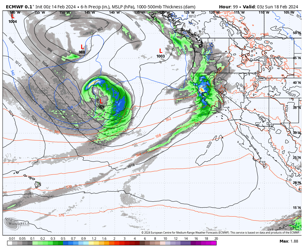
The next storm approaches the coast Sunday night. The models don’t agree on the timing of precipitation reaching the Sierra, but we could see some showers after midnight and heavier snow Monday into Tuesday as low pressure sits near the coast and directs moisture north-northeast into CA.
We are expecting southerly flow which could limit the amount of precipitation that makes it over the mountains unless the stronger surge with direct aim of an AR takes aim at the northern Sierra. The GFS model shows some better spillover with 2-3 inches of liquid falling, while the European model shows the heaviest precipitation staying along the coast up to the foothills.
The models disagree on whether the storm clears out for Wednesday or if showers change on through the day, so we’ll watch that as well. Snow levels still look to hold close to the base over the 2-3 day period. We’ll continue to watch the trends and will have a more detailed snowfall forecast starting Thursday.
Quieter Pattern:
The long-range models still show weak high-pressure building in by Thursday with quieter weather through Saturday the 24th. Some models are weaker with the high pressure and try to sneak in a weak system, while other models are stronger and keep us dry over the 3-day period. Either way, it looks pretty quiet compared to the pattern through Wednesday.
Long-Range Forecast:
The long-range models are still showing a cold trough pattern for the West Coast starting around the 25th through the end of the month, a similar setup to what we saw during the 1st half of January.
If this pattern sets up for the last 5 days of the month into the beginning of March, we could see some colder storms drop into the trough with some storms that bring some powdery snow to the mountains. We’ll continue to watch the trends.
BA


