Skip to content
Palisades Tahoe Logo Palisades Tahoe Logo Palisades Tahoe Logo
Explore
Main Menu
  • Explore Palisades Tahoe
  • Base to Base Gondola
  • Our New Name
  • Explore Legendary Lifts
  • Palisades Tahoe Blog
  • About Lake Tahoe
  • About Us
Plan Your Visit
Main Menu
  • Tickets & Passes
  • Lodging
  • Lessons & Guides
  • Deals & Packages
  • Rentals & Demos
  • Travel Here
  • Getting Around
Mountain Information
Main Menu
  • Snow and Weather
  • Lift and Grooming Status
  • Webcams
  • Hours of Operation
  • Trail Maps
  • Parking & Road Conditions
  • Snowfall Tracker
Events & Activities
Main Menu
  • Events Calendar
  • Activities
  • Dining & Apres
  • Shopping
  • Things To Do In Lake Tahoe
  • Groups, Meetings & Weddings
  • Ski & Snowboard Teams
IKON PASS HOLDER LODGING DISCOUNT

Ikon Pass holders save up to 20% on slopeside lodging at The Village at Palisades Tahoe.

SLOPESIDE LODGING
Icon / FlashCreated with Sketch.
View All Offers
  • Weather

Rain & Snow with Strong Winds Thu – Fri

  • Mar 8, 2023
  • 1:25 pm

Snowfall Report:

An additional 6 inches of snow had fallen on the mountain in the past 24 hours as of 5 AM Wednesday. That brings the 4-day storm totals to 58 inches and counting as the snow continued to fall Wednesday morning!

Wednesday Weather:

The skies are clearing Wednesday afternoon behind the final wave of the cold storm series that was with us for around two weeks. Gusty winds continue over the ridges. Highs are in the teens up top and 20s at the base.

Thursday – Friday Night Storm:

Thursday we will see increasing clouds and winds with highs in the 30s. Ridgetop winds from the southwest increase to 70-80+ mph by afternoon. Snow showers could move in by late morning with steadier snow in the afternoon with snow levels starting out near the base. We could see several inches by the end of the day.

Thursday night heavy rain and snow push in with rising snow levels. We expect heavy precipitation through Friday night. Strong winds over 100+ mph Friday will likely keep many lifts closed. Snow levels rise overnight to around 7300-7800 ft. Thursday night into Friday morning, and possibly peaking around 7500-8000 ft. Friday. Friday night snow levels could drop back to the base.

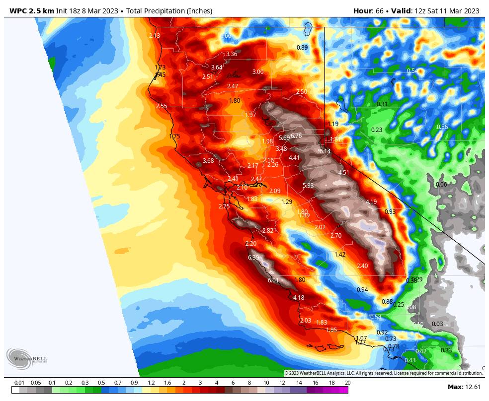
We expect heavy rain at the base up to 7000 ft. with this storm. There is a boom/bust zone for snowfall between 7000-8000 ft. depending on snow levels. Above 8000 ft. we should see mostly all snow. Here is the updated forecast for expected snowfall totals by Saturday morning.

  • 10-16 inches at the base.
  • 20-26 inches at mid-mountain elevations.
  • 42-51+ inches up top.

Saturday – Sunday Storm:

The moisture continues to stream into the Sierra Saturday through Sunday night aided by another wave moving through. Winds should be lighter both days but still gusting up to 50-60+ mph up top from the west-southwest. Highs in the 30s.

Snow levels could fluctuate between the base and 6800 ft. through the 2-day period. That means some rain could mix with snow or change to rain at times near the base. Above 7000 ft. we should see mostly all snow but not the powdery snow we have been seeing. Here is the forecast for snowfall for Saturday through Sunday night.

  • 15-22 inches at the base.
  • 21-27 inches at mid-mountain elevations.
  • 27-34+ inches up top.

Long-Range:

Another strong and wet storm is expected to move in Monday and could last into next Wednesday the 15th. We could see another round of heavy rain and snow with fluctuating snow levels and gusty winds. More details as we get closer.

We could see a break next Thursday into Friday the 17th, but we could see more storms into the last week of March. More details as we get closer.

BA

lake tahoe weather palisades tahoe weather forecast snowfall forecast
Bryan Allegretto
Bryan Allegretto

Share this article:

Recent Posts

  • Weather ·
  • March 24, 2023·

Drier w/ Spotty Snow Showers thru Sunday

Snowfall Report: 3-5 inches of new snow fell on the mountain, from the base to the upper mountain, in the…
Read more
  • Weather ·
  • March 23, 2023·

Snow Thursday, Drier for the Weekend

Snowfall Report: An additional 2 inches of snow fell on the mountain in the past 24 hours as of 5…
Read more
  • Weather ·
  • March 22, 2023·

Scattered Snow Showers Continue

Snowfall Report: We were expecting 1-4 inches to fall Tuesday-Tuesday night. We picked up the lower end of the forecast…
Read more

Social

Instagram Twitter Facebook Youtube

Contact

   Email Us
   1.800.403.0206

Our Partners

U.S. Forest Service Logo
1960 Olympic Valley Road
Olympic Valley, CA 96146

©2022 Palisades Tahoe

Alterra Mountain Company
  • Privacy Policy
  • Terms of Service
  • Photo Upload Terms of Use
  • Accessibility
  • Do Not Sell My Personal Information
  • Privacy Policy
  • Terms of Service
  • Photo Upload Terms of Use
  • Accessibility
  • Do Not Sell My Personal Information