Tuesday Weather:
Mostly sunny for Tuesday with lighter winds. A few clouds around and a chance for a scattered shower during the afternoon. The best chance for a shower will be in the afternoons with the daytime heating and afternoon convection. Highs in the 30s for the upper elevations and 40s for the lower elevations.
Wednesday – Thursday Storm:
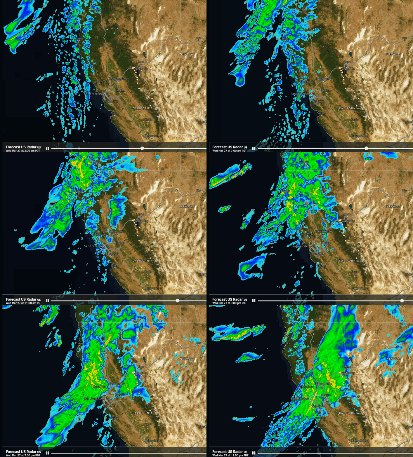
Wednesday will be a transition day similar to last Friday, with increasing winds and clouds throughout the day. Highs in the 30s for the upper elevations and 40s for the lower elevations. Ridgetop winds from the southwest gusting up to 70-80+ mph by the end of the day closing some ski lifts early. Rain & high elevation snow showers could reach the mountain by late afternoon.
Wednesday evening the main band of steadier precipitation associated with the cold front pushes in and moves through with the cold front overnight. We’ll see a period of heavier snowfall overnight with falling snow levels, starting up around 7000-7500 ft. Wednesday afternoon and dropping below the base by late evening.
Then scattered snow showers for Thursday into Thursday night with highs in the 30s. Ridgetop winds will still be gusty on Thursday, possibly continuing to affect some upper mountain lifts. Most of the precipitation/snow is expected to fall by Thursday morning, which means most falls Wednesday night during lower average snow ratios around 10-15:1 between 7000-9000 ft.
By Friday morning we could see storm totals of around 5-9 inches at the base, 10-15 inches near mid-mountain, and 13-18 inches up top. Most of that falling by Thursday morning and a final inch or two with the snow showers Thursday.
Friday – Sunday Storm:
The latest model runs have started to trend the weekend storm farther south with the precipitation forecasts starting to trend downward.
We should see snow showers increase again by Friday afternoon as moisture with the next storm flows into the Sierra. The steadiest snow is still expected Friday night as a weak and thin moisture stream is aimed at the northern Sierra that slides south. Then snow showers are possible for Saturday into Sunday as the flow turns easterly on the north side of the low to our south.
Highs in the 30s through the weekend. We could see the sun peek out at times on Sunday with the scattered showers. The winds don’t look as strong with this storm as the previous storm. Snow levels staying below the base.
By Monday morning we could see storm totals of around 6-11 inches at the base, 8-13 inches near mid-mountain, and 10-15 inches up top. 50-60% of the snow could fall by Saturday morning. In total by Monday morning, we have a shot at breaking two feet of total snowfall from the two storms. But that could change if the second storm trends any farther south.
Drier Start to April:
The long-range models continue to show high-pressure building in over the West Coast by Monday the 1st of April through Wednesday the 3rd. That will bring a brief break in the unsettled pattern with mostly sunny skies expected each day, and highs warming into the 40s.
Unsettled Pattern Returns:
By the 4th of April through the 8th, the long-range models continue to show the ridge shifting east with a trough settling in over the West.
The trend with this trough is for it to be over the West vs over the West Coast, which could mean that as the storm door opens we mainly see storms dropping down over land or to our east. That would mean weaker storms are likely between the 4th-8th along with colder air. We’ll continue to watch the trends.
Long-Range Outlook:
There are some signs that beyond the 8th high pressure in the eastern Pacific could shift a bit closer to the West Coast. That could mean we have less of a chance for weak storms beyond the 8th, or weaker storms.
Any moisture around during A[pril can cause afternoon showers to develop over the mountains with the convection from daytime heating with the higher and stronger sun angle in spring. We’ll keep an eye out for those conditions in April as well.
BA


