Skip to content
Palisades Tahoe Logo Palisades Tahoe Logo Palisades Tahoe Logo
Explore
Main Menu
  • Explore Palisades Tahoe
  • Base to Base Gondola
  • Our New Name
  • Explore Legendary Lifts
  • Palisades Tahoe Blog
  • About Lake Tahoe
Plan Your Visit
Main Menu
  • Tickets & Passes
  • Lodging
  • Lessons & Guides
  • Deals & Packages
  • Rentals & Demos
  • Travel Here
  • Getting Around
Mountain Information
Main Menu
  • Snow and Weather
  • Lift and Grooming Status
  • Webcams
  • Hours of Operation
  • Trail Maps
  • Parking & Road Conditions
  • Snowfall Tracker
Events & Activities
Main Menu
  • Events Calendar
  • Aerial Tram
  • Activities
  • Dining & Apres
  • Shopping
  • Groups, Meetings & Weddings
  • Ski & Snowboard Teams
Winter Lodging Exteriors of the Village at Palisades Tahoe
Book Winter Early

Ikon Pass holders save up to 25% when you book with The Village at Palisades Tahoe this winter.

SAVE ON LODGING
Icon / FlashCreated with Sketch.
View All Offers
  • Weather

Mild Weekend with Increasing Clouds

  • Mar 26, 2022
  • 8:53 am

Saturday:

Sun and some clouds for Saturday. Highs into the 60s at the base and 50s up top. Breezy southwest winds with gusts up to 30+ mph up top.

Sunday Night – Monday System:

Sunday we should see increasing clouds and winds during the day with highs into the 50s. South winds gusting up to 60+ mph up top. Marginal for affecting lifts but we could see a few upper mountain lift wind holds if winds are strong enough.

The latest forecast model runs track the next storm into Central CA with the heaviest precipitation to the south of the Tahoe Basin. Light precipitation could reach the mountain between 11 PM – 5 AM Sunday night and could continue into Monday evening before clearing out Monday night. Highs drop into the 30s on the mountain to near 40 degrees at the base Monday, with the winds dropping through the day.

Snow levels could start out between 7000-8000 ft. Sunday evening and then fall overnight and should be near to just above the base by Monday morning (6000-7000 ft.). Then they could rise again Monday up to 6300 – 7300 ft. by afternoon and then back down to 6000-7000 ft. again by the end Monday evening. Snow levels tend to be higher with lighter precip like drizzle and lower under any heavier showers.

Based on the latest forecast model runs, we could see 0-1 inches at the base with a rain to snow to rain to snow back and forth possible. The upper mountain could see 1-4 inches of new snow by Monday evening. 

Tuesday – Friday:

Tuesday through the end of the week high-pressure edges in along the West Coast. That should keep us dry with mostly sunny skies through the end of the week. Highs could return to the 50s at the base and 40s up top. A trough dropping down to our east Thursday could bring a shot of cooler air and northeast breezes.

Long-Range:

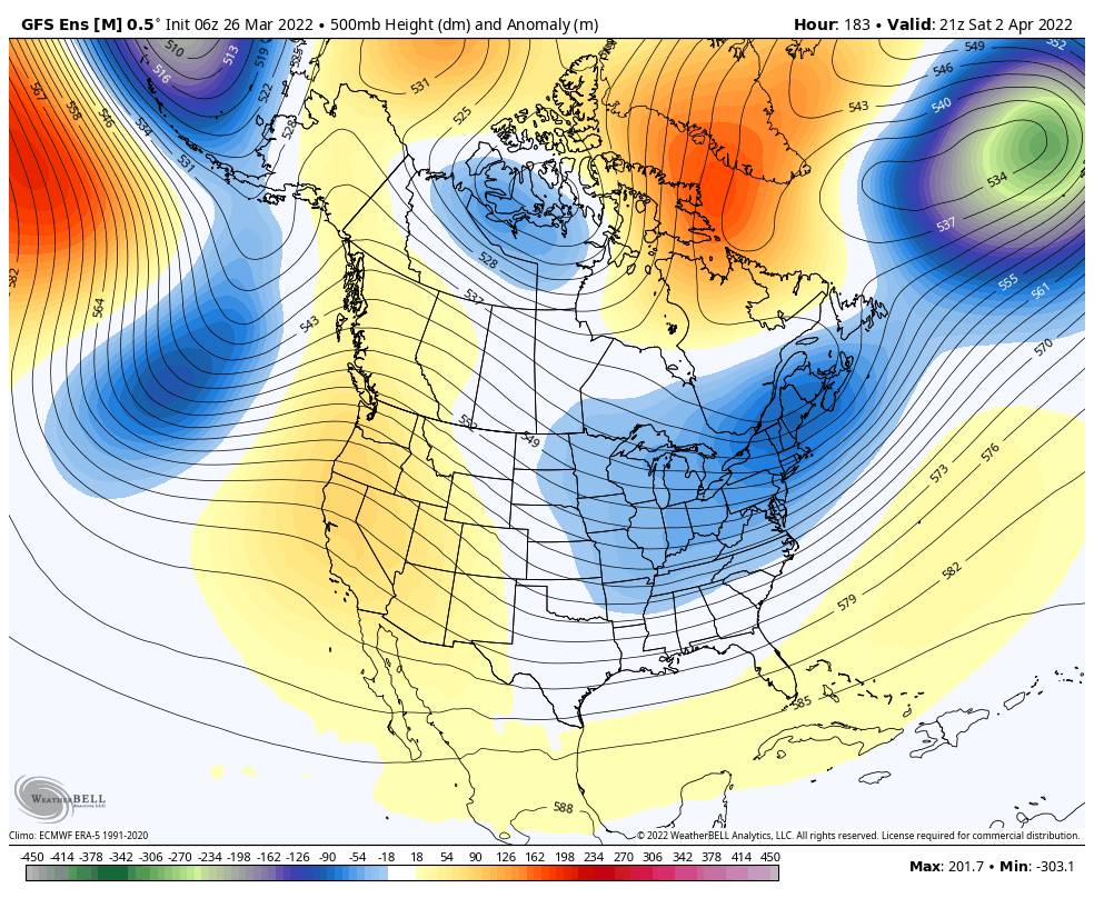
For the first weekend in April, we have the return of the Winter Wondergrass Festival after a two-year absence! The weather could be springlike if the latest forecast model runs verify. Right now it looks like mostly sunny skies with highs near 60s degrees at the base and 50s on the mountain.

The week of the 4th the long-range models are hinting at a pattern change back to cooler and more unsettled weather, with the chance for a weak storm or two brushing us with light precipitation. But the storm track could also stay to our north. We will continue to watch the trends as we get closer.

BA

lake tahoe weather palisades tahoe weather forecast snowfall forecast
Bryan Allegretto
Bryan Allegretto

Share this article:

Recent Posts

  • Weather ·
  • September 19, 2023·
The predicted El Nino pattern for this winter

2023-24 Palisades Tahoe Winter Forecast Preview…

As we look ahead to the 2023-2024 winter season, it's important to remember that any winter outlook will contain an inherent degree of uncertainty. However, there are a few clues that we can keep an eye on.
Read more
  • Weather ·
  • May 8, 2023·

Final Forecast of the 2022-23 Season

First Week of May Snowfall Report: The first week of May was a cold and snowy one. The upper mountain…
Read more
  • Weather ·
  • May 1, 2023·

Snowy First Week of May

Monday – Friday Snow Shower Chances: A low-pressure system will be making its way south down the coast on Monday…
Read more

Social

Instagram Twitter Facebook Youtube

Contact

   Email Us
   1.800.403.0206

Our Partners

U.S. Forest Service Logo
1960 Olympic Valley Road
Olympic Valley, CA 96146

©2022 Palisades Tahoe

Alterra Mountain Company
  • Privacy Policy
  • Terms of Service
  • Photo Upload Terms of Use
  • Accessibility
  • Do Not Sell My Personal Information
  • Privacy Policy
  • Terms of Service
  • Photo Upload Terms of Use
  • Accessibility
  • Do Not Sell My Personal Information