

Friday:
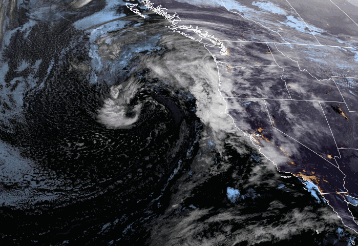
The impending storm is spinning off of the West Coast Friday morning, starting to stream some clouds into CA.
We will see increasing winds through the day with ridgetop gusts up to 60-70+ mph by the end of the day. That should close some upper mountain ski lifts by afternoon at exposed mountains. Highs in the 40s. We could see a few rain showers reach the mountain during the afternoon, with snow levels up around 7500-8000 ft.
The Storm:
The steadier precipitation ahead of the cold front pushes in during the evening hours, with snow levels falling to the base by midnight and heavy snow into the early morning hours Saturday with the passage of the front. Then diminishing intensity with scattered snow showers on Saturday.
The latest model runs keep the snow showers lighter, but we could see a few steadier showers move through at times. They show a better chance for a few steadier snow bands to move through Saturday night as the main low-pressure center moves inland.
Highs in the 30s for the lower elevations on Saturday and 20s for the higher elevations. Ridgetop winds gusting up to 50-60+ mph from the west through the day. That could keep a few lifts closed on the upper mountain.
Most of the snow is expected to fall Friday night, up to 80%, which means most of the snow is falling when snow levels are also falling and snow ratios are lower overall, and then higher snow ratios for the snow showers Saturday – Saturday night. Total snowfall by Sunday morning could be around 6-11 inches at the base, 12-17 inches near mid-mountain, and 14-20 inches up top.
Monday – Wednesday Weather:
We will see scattered snow showers on Sunday, especially in the morning, and then some clearing and partly sunny skies into the afternoon. The winds drop and it should be a nice day, but cold with highs in the 30s.
Monday we will see partly sunny skies with a few clouds and scattered snow showers possible. Highs in the 30s to near 40 degrees at the base. Then we could see a break on Tuesday with mostly sunny skies and a few clouds, with highs into the 30s on the mountains and low 40s at lake level.
The latest model runs have delayed the arrival of the next storm until Wednesday evening-night, so I’ll leave that storm out of the short-range detailed forests for one more day. Wednesday could be similar to today (Friday) with an approaching storm bringing increasing winds and clouds through the day. Ridgetop gusts up to 60-70+ mph by afternoon and highs in the 30s to near 40 at the base.
Long-Range Forecast:
The storm door remains open through next Saturday the 30th, with a storm forecast to move through Wednesday night into Thursday and another storm is possible for sometime next Friday the 29th into Saturday the 30th.
Both storms have the potential to bring a decent shot of snow (several inches or more) if the forecasts remain on track. I’ll have more details on potential snowfall for the Wed-Thu storm starting on Saturday.
We could clear out for the last day of the month. The long-range models continue to show high-pressure building in over the West Coast for the first few days of April. That should bring at least a few drier and slightly milder days to start the month.
Then the trends are still toward the ridge shifting westward with troughing over the West Coast by the 4th – 7th. That would keep the below-average temperatures around the West and could re-open the door to storms. But it’s April and storms are usually weaker. With the door open we could see some April snow and a lack of warm spring weather through at least the first week of April.
BA
