Monday:
Mostly to partly sunny skies for Monday as some high clouds move in during the day ahead of the next storm. Highs into the 50s at the base and 40s on the upper mountain. The winds are going to crank back up ahead of the next storm. Ridgetop winds gusting up to 60+ mph from the southwest in the morning and up to 100+ mph by the end of the day. That should close some upper mountain lifts.
Monday Night – Tuesday Storm:
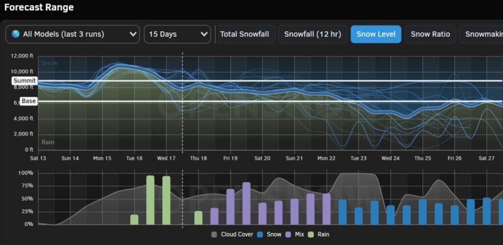
Rain & snow should push in around 1-3 AM Monday night. Snow levels start up around 6500-7500 ft. and fall to 6000-7000 ft. by Tuesday morning. The heaviest precipitation is expected Tuesday morning as a front moves through. Then we should see the precipitation diminish into the afternoon and clear out by evening. Snow levels could dip a few hundred feet lower under the heaviest showers before bumping back up by afternoon.
Highs in the 30s. Ridgetop winds gusting up to 90+ mph first thing in the morning and then falling to 40+ mph from the west by the end of the day. That could delay some lift openings on the upper mountain.
At the base, we could see a change to snow Tuesday morning but we should start as rain and could finish with some rain. A coating up to 4 inches of new snow is possible depending on the snow levels, and 3-8 inches of new snow expected on the upper mountain by Tuesday evening.
Wednesday – Friday Storm:
We may have a break between storms Tuesday night into Wednesday morning, but then rain & snow showers push back in by Wednesday afternoon. Snow levels up around 7000-8000 ft. to start with rain at the base and on the lower mountain. Highs into the 30s and near 40 degrees at the base. Ridgetop winds gusting up to 80+ mph from the SW likely closing some upper mountain lifts.
Wednesday night and Thursday we will see heavier precipitation as a couple of waves rotate inland around the main low off the coast. Highs in the 30s. Winds gusting up to 90+ mph up top Thursday morning and falling to 50-60+ mph during the afternoon, which should delay some upper mountain lift openings. Snow levels falling near the base around 6200-6700 ft. by Thursday morning and to 5100-5600 by evening.
As the main low moves through Thursday night into Friday lighter showers could continue into Friday afternoon before clearing out by evening. Snow levels fall below 5000 ft. Thursday night and then could bump back up to 5800-6800 ft. by Friday afternoon. That could mean a few rain showers are possible at the base at the end.
This should be an impressive snowstorm by April standards if the current forecasts hold. 5-10 inches of new snow is possible at the base, and 15-24 inches on the upper mountain by Friday afternoon. We will continue to fine-tune the forecast as we get closer.
Long-Range:
The weather should become nicer over the weekend as high pressure builds in. We could see sunny skies and highs warming into the 40s Saturday and then 50s at the base Sunday. We should have lighter winds as well.
The storm track will be just to our north by the end of next week into early May, so we will have to watch for any possible storms trying to dip into northern CA. We’ll keep an eye on the trends for late month into May. Closing day is still slated for 5/1, but that could change if we see enough snow this week.
BA