

We are finishing out our 3.5-week dry spell this weekend into the start of next week. Then a more active weather pattern is expected by Tuesday night and possibly through the long-range. It’s nice to be talking about storms again.
Saturday – Monday:
Partly-mostly sunny days and mild temperatures. Highs into the 50s with overnight lows in the 30s and 40s.
Tuesday – Thursday Rain Chances:
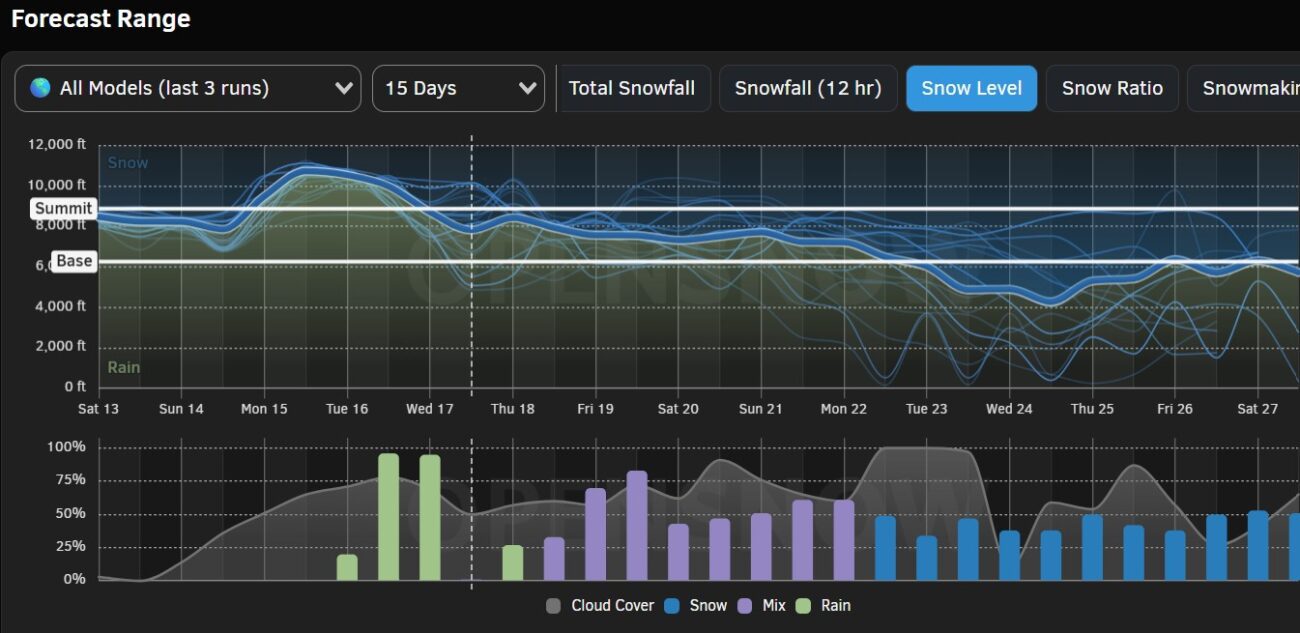
Partly sunny on Tuesday with some clouds and the chance for a passing shower. Tuesday night into Wednesday, the next storm pushes just far enough south to catch the Tahoe basin with some rain and very high elevation wet snow. The latest model runs have the storm clearing by the end of the day on Wednesday.
Ridgetop winds increase from the west up to 70-80+ mph. Highs in the 40s with 30s for the higher elevations. The average this morning among the forecast models is for around 0.75 inches of total precipitation falling over the mountain.
We’ll have to watch the trends on this, as we are on the very southern edge of the precipitation. But it won’t matter too much as snow levels are expected to start out around 10,000+ feet and only briefly dip near 8000-8500 ft. on Wednesday before rising again. With the very high snow levels, we aren’t expecting much snow below 9000 ft.
Behind the storm, we still expected gusty winds on Thursday with a chance for scattered showers. But mainly drier with partly sunny skies. Highs in the 40s.
Storms Next Weekend:
The next storm is expected to push in around Friday into next Saturday, the 20th. We’ll continue to watch the trends on this system as well. This system and another that could push in next Sunday, the 21st, look to tap into some subtropical moisture with ARs possibly associated with them.
That will bring us high snow levels again, but the latest forecasts are a bit lower, in the 7000-8000 ft. range. These storms could be pretty wet as well. If they stay on track, we could see accumulating snow on the upper mountain. I’m not looking forward to the headache of forecasting snow levels next weekend, but I am looking forward to the storms continuing.
Long-Range Outlook:
By the 22nd through Christmas and into the last week of December, the long-range models continue to show a deep trough digging south along the West Coast. In that position, the storms will spin up into the base of the trough, which is far enough south to tap into subtropical moisture and to form ARs (atmospheric rivers) with a lot of moisture drawn in or aimed into CA.
But the deep trough will also allow colder air to funnel south. It could be a battle of warmer moisture and colder air. The one caveat is keeping an eye on the position of the trough and the ridge to the east as we get closer. If the trough sets up too far off the coast, the storms can get stuck off the coast and have a harder time pushing inland into CA. So far, the models show them pushing inland.
Therefore, we continue to be cautiously optimistic. If everything comes together just right, we could see significant snowfall between the 22nd – 27th. But we are still 10+ days out from this period. We need the trough to stay over the West Coast on the forecast models as we get closer, and any storms tapping into subtropical moisture from the south could still bring us snow level issues even with the colder air.
Things are looking better as the storms return and hopefully colder storms Christmas week. We’ll continue to watch the trends and to hope the long-range models are right…
BA
