Snowfall Report:
No surprises with the weak and windy system that moved through Friday as it dropped 1 inch on the upper mountain.
Saturday Daytime Hours:
We have a break between storms during the day on Saturday with increasing clouds and winds through the afternoon. Highs in the 30s on the mountain and near 40 degrees at the base.
Ridgetop winds are gusting up to 40+ mph from the west Saturday morning and will increase to 60-70+ mph by the end of the day. That could start to close some upper mountain lifts before the end of the day.
Saturday Evening – Sunday Evening Storm:
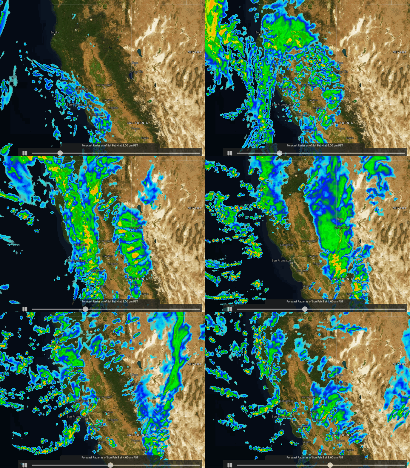
Snow is expected to move in between 4-6 PM Saturday with snow levels dropping below the base pretty quickly, either at the start or within a few hours. The heaviest snow falls later Saturday night into Sunday morning as the cold front moves through. Then moderate snow showers Sunday become lighter into the afternoon and more scattered into Sunday evening as the storm winds down by around 5-7 PM.
Highs in the 20s. Ridgetop winds from the west gusting up to 60-70+ mph early Sunday morning and then dropping through the day. That could delay some upper mountain lift openings Sunday morning but most should open through the day after everything is dug out and the winds come down.
We could see 12-18 inches of snow by the opening bell Sunday, with several more inches falling during the day on Sunday. I made a slight increase in the total & final snowfall forecast this morning as the forecast models have trended slightly wetter with the storm. By early Monday morning we could see:
- 14-20 inches at the base.
- 18-24 inches at mid-mountain elevations.
- 22-28 inches up top.
A classic Sierra snowstorm that will drop 14-28 inches from bottom to top in 24 hours.
Monday – Friday:
Monday through Friday the 10th, high pressure builds in over CA. That will bring us a drier pattern with mostly sunny skies most days through the period. Still a bit chilly Monday with highs in the 30s and brisk northeast winds gusting up to 30+ mph up top. Then highs in the 30s on the upper mountain and 40s at the base starting Tuesday, along with lighter winds.
Next Weekend:
Next Saturday the 11th currently looks dry as well with similar weather as the rest of the week. By next Sunday the 12th a cut-off low could be spinning off of the CA coast. At some point, it moves inland. We’ll have to watch the timing and the track as it does.
We could see some precipitation as early as next Sunday if the low moves inland over central CA, or it could take until at least Monday the 13th. It could also move inland to our south and miss us. So we’ll be watching the trends all week.
Long-Range:
By the mid-month (2/14) into the 3rd week of February, we could see a trough dig in over the West and CA, and that pattern could last into the last week of February. That could start to open up the pattern to more storms moving into northern CA during the 3rd week of the month, and possibly continuing into the last week of February.
We’ll continue to watch the trends to see if we could see a more active storm track during the 2nd half of the month after a drier period during the 2nd week of February.
BA


