Skip to content
Palisades Tahoe Logo Palisades Tahoe Logo Palisades Tahoe Logo
Explore
Main Menu
  • Explore Palisades Tahoe
  • Base to Base Gondola
  • Our New Name
  • Explore Legendary Lifts
  • Palisades Tahoe Blog
  • About Lake Tahoe
  • About Us
Plan Your Visit
Main Menu
  • Tickets & Passes
  • Lodging
  • Lessons & Guides
  • Deals & Packages
  • Rentals & Demos
  • Travel Here
  • Getting Around
Mountain Information
Main Menu
  • Snow and Weather
  • Lift and Grooming Status
  • Webcams
  • Hours of Operation
  • Trail Maps
  • Parking & Road Conditions
  • Snowfall Tracker
Events & Activities
Main Menu
  • Events Calendar
  • Activities
  • Dining & Apres
  • Shopping
  • Things To Do In Lake Tahoe
  • Groups, Meetings & Weddings
  • Ski & Snowboard Teams
IKON PASS HOLDER LODGING DISCOUNT

Ikon Pass holders save up to 20% on slopeside lodging at The Village at Palisades Tahoe.

SLOPESIDE LODGING
Icon / FlashCreated with Sketch.
View All Offers
  • Operations

Operations Update: February 8

  • Feb 7, 2017
  • 4:11 pm

Both Mountains Closed Today, February 7, 2017

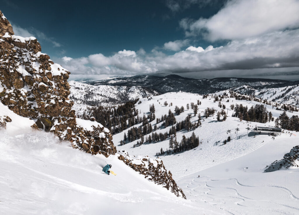
Last night the storm brought 16 inches of new snow to Alpine Meadows’ upper mountain and 10 inches to Squaw Valley’s upper mountain. Over the course of the evening, snow levels rose bringing heavier, wetter snow and rain to the mountains. Rain on top of new snow causes very unstable snow conditions. Check out today’s warning from the Sierra Avalanche Center, which remains in effect until 7am tomorrow. Snow instability paired with VERY high winds (145mph gusts on the ridge!) prevented us from safely opening the mountains today. 

The Storm Continues

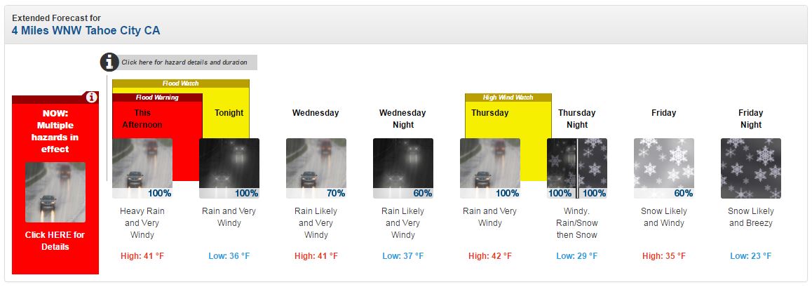
We are currently experiencing heavy rainfall, which is expected to continue through Thursday. Here is the lastest forecast from The National Weather Service: 

  • This Afternoon: Rain. The rain could be heavy at times. High near 41. Very windy, with a southwest wind around 55 mph, with gusts as high as 85 mph. Chance of precipitation is 100%. New precipitation amounts between a quarter and half of an inch possible.
  • Tonight: Rain. Low around 36. Very windy, with a southwest wind 30 to 40 mph, with gusts as high as 60 mph. Chance of precipitation is 100%. New precipitation amounts between a half and three quarters of an inch possible.
  • Wednesday: Rain likely. Cloudy, with a high near 41. Very windy, with a southwest wind 30 to 40 mph, with gusts as high as 55 mph. Chance of precipitation is 70%. New precipitation amounts between a half and three quarters of an inch possible.

 NOAA has also issued a Flood Warning and High Wind Watch for the area. Please be careful on the roads: do not drive into any flooded area and follow the direction of Emergency Management officials!

Snow Thursday Night & Friday

The good news is that the next storm is expected to transition from rain to snow on Thursday night. Our weather blogger updated his forecast for this next storm phase today at 5:26am:

“Thursday the next storm pushes closer and the heavy precip returns in the afternoon, with snow levels still around 9000 feet. Then Thursday night a cold front pushes in colder air and snow levels begin to fall to 7000 feet by Friday morning, and then hovering around 6500 feet during the day Friday behind the front. We could see 2-10 inches on the mountain by Friday afternoon. Friday night a final wave may push in with snow levels dropping below the base. We could see 3-6 inches at the base, and 5-8 inches on the mountain before the snow finally tapers off by Saturday morning.”

We will be left with new snow and clear skies starting Saturday!

TOMORROW’S OPERATIONS OUTLOOK, FEBRUARY 8, 2017

Persistent high winds and unstable snow will continue challenge our operations. Additional control work will need to be completed before we can open any of our slopes. Our crews are geared up to tackle this and will do so if conditions allow. Safety is our top priority, especially during these dynamic storm cycles. Our crews will assess conditions first thing in the morning, so please check our lift & trail status page and app for updates. 

admin
admin

Share this article:

Recent Posts

  • Operations ·
  • March 14, 2023·
Two PistenBully snowcats in a storm at Palisades.

Operations Update: Wednesday Re-Opening Plans

Tomorrow, Wednesday, March 15th, we plan to reopen both Alpine and Palisades. We appreciate your patience with us being closed today: Our teams NEEDED this day to try to get ahead a bit, and snow conditions are not conducive to a good day of skiing -- It rained as far up as 9,000 feet at times. We spent the day continuing to dig out, performing snow safety, addressing flood zones, and preparing for the few days ahead that have a break in the weather. Tomorrow, we still expect that some of our lifts will be delayed. We will start with a lower mountain offering and expand throughout the day as we can.
Read more
  • Operations ·
  • March 13, 2023·
A snowcat completely buried in snow during a storm.

Operations Update: Palisades Tahoe Will Be Closed Tuesday, March 14th

Tonight, another wet storm moves into the Tahoe area. Winds are projected to be over 100 miles per hour on…
Read more
  • Operations ·
  • March 11, 2023·
Two patrollers trying to get into the KT Patrol Shack.

Operations Update: The Never-Ending Storm Cycle + Sunday Expectations

Following a very wet 36 hours, we achieved the opening goals we set yesterday and got every lift that we expected today, thanks to the hard work of our ops teams. Seriously, it is hard work out there: So many people are out there digging chairlifts out by hand after spending the early morning hours digging their vehicles and homes out first. Our snowpack is very saturated with water and heavy, which can also make things difficult for our grooming machines. We truly have no clear days in the forecast to recover from this wet weather event, so we appreciate your patience.
Read more

Social

Instagram Twitter Facebook Youtube

Contact

   Email Us
   1.800.403.0206

Our Partners

U.S. Forest Service Logo
1960 Olympic Valley Road
Olympic Valley, CA 96146

©2022 Palisades Tahoe

Alterra Mountain Company
  • Privacy Policy
  • Terms of Service
  • Photo Upload Terms of Use
  • Accessibility
  • Do Not Sell My Personal Information
  • Privacy Policy
  • Terms of Service
  • Photo Upload Terms of Use
  • Accessibility
  • Do Not Sell My Personal Information