Skip to content
Palisades Tahoe Logo Palisades Tahoe Logo Palisades Tahoe Logo
Explore
Main Menu
  • Explore Palisades Tahoe
  • Base to Base Gondola
  • Our New Name
  • Explore Legendary Lifts
  • Palisades Tahoe Blog
  • About Lake Tahoe
Plan Your Visit
Main Menu
  • Tickets & Passes
  • Lodging
  • Lessons & Guides
  • Deals & Packages
  • Rentals & Demos
  • Travel Here
  • Getting Around
Mountain Information
Main Menu
  • Snow and Weather
  • Lift and Grooming Status
  • Webcams
  • Hours of Operation
  • Trail Maps
  • Parking & Road Conditions
  • Snowfall Tracker
Events & Activities
Main Menu
  • Events Calendar
  • Aerial Tram
  • Activities
  • Dining & Apres
  • Shopping
  • Groups, Meetings & Weddings
  • Ski & Snowboard Teams
Winter Lodging Exteriors of the Village at Palisades Tahoe
Book Winter Early

Ikon Pass holders save up to 25% when you book with The Village at Palisades Tahoe this winter.

SAVE ON LODGING
Icon / FlashCreated with Sketch.
View All Offers
  • Operations

Operations Update: February 2

  • Feb 2, 2017
  • 6:52 am

Today’s Overview, February 2, 2017

Today high winds are here to accompany the storm and will likely affect operations. With wind gusts over 70mph, upper mountain lifts at both Squaw Valley and Alpine Meadows are on wind hold or wind closure. Check out NOAA’s wind sensors:

  • Squaw Summit (el. 8700′)
  • Alpine Meadows Summit (el. 8643′)

Check our lift status page or app for real-time updates throughout the day.

The Incoming Storm

Here is the most recent weather update from resident weather blogger, BA. Updated at 5:46am on February 1, 2017:

Light Snow

Early Thursday morning the next storm moves in. Only expecting light to moderate precip Thursday. Snow levels start near the base and could rise to 7000 feet during the day. We could see a coating to an inch at the base before the change to rain, and 1-5 inches on the mountain.

Heavier Snow

We may see a break in the precip Thursday night and then heavier precip Friday as a front moves through. Snow showers could continue into Friday night. Snow levels start around 7000 feet Friday and could fall to the base by Friday evening. We could see an additional 2-4 inches at the base by Saturday morning, and 10-22 inches on the mountain. Mountain top gusts near 80 mph. Thursday and Friday.

-BA

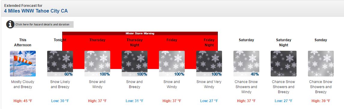
NOAA Winter Storm Warning

NOAA has issued a Winter Storm Warning from 1am Thursday to 4am Saturday above 6,500 feet (updated 3:13pm on February 1):

  • “TIMING: Snow will move into the Sierra late tonight…becoming moderate to heavy Thursday Morning. Snow is expected to decrease substantially in intensity Thursday afternoon and evening before becoming moderate to heavy again for late Thursday night through Friday.
  • SNOW ACCUMULATIONS: 1 to 3 feet above 7000 feet…highest along the Sierra Crest…with 6 to 12 inches from 6500 to 7000 feet and up to 6 inches down to lake level.  
  • WINDS: South to Southwest 10 to 20 with gusts to 45 mph. Ridge gusts up to 90mph.  
  • SNOW LEVELS: Rising from 6000 feet tonight to around 7000 feet Thursday afternoon. Snow levels will fall to around 6500 feet Friday, then to lake level Friday Night.
  • IMPACTS: Travel will become difficult due to snow covered roads and low visibility across the Sierra Passes…especially Thursday morning to early afternoon and again late Thursday night and Friday.”

Operations for Tomorrow, February 3, 2017

According to NOAA Weather Discussion, “ridges will gust up to 100 mph with the strongest gusts expected Friday and Friday night.” With this forecast in mind, wind holds on upper mountain at both Squaw Valley and Alpine Meadows are possible tomorrow. Our operations crews will assess conditions in the morning, so please check our app and lift status page for updates.

admin
admin

Share this article:

Recent Posts

  • Operations ·
  • August 31, 2023·
Sunrise Snowmaking at Palisades

Operations Blog: Snowmaking 101

When the autumn chill moves into the Tahoe region, those thoughts of impending winter start to creep back in. For our snowmaking department, this is when the season starts. Our snowmakers take a lot of pride in being the ones to kick off winter. The heavy anticipation of what's to come is ingrained in the work that they do. Once they've started making a significant amount of snow, other departments like Grooming can start work, too, and before you know it, winter has begun.
Read more
  • Operations ·
  • June 29, 2023·
A drone shot of the snowpack at Alpine in June.

Operations Update: Closing Weekend Expectations

The closing celebration of the historic 2022-23 winter season is here! We'll be saying goodbye to winter with skiing, t-shirt giveaways, live music, and more at Alpine. We've also got some warm temperatures in the forecast and a new parking program for this event. Here's what to expect.
Read more
  • Operations ·
  • June 5, 2023·
A Funitel cabin in low visibility during a winter storm.

Operations Blog: Funitel Haul Rope Project Updates

This summer, we will be replacing the haul rope on the Funitel. The haul rope is the main cable you see carrying cabins to and from the upper mountain. This project has been scheduled for over two years: it is a major and necessary maintenance project that requires significant advance planning. Crews from the lift manufacturer will be coming from Europe to assist with this project as well. We'll be posting updates to this blog each time something exciting happens with this project.
Read more

Social

Instagram Twitter Facebook Youtube

Contact

   Email Us
   1.800.403.0206

Our Partners

U.S. Forest Service Logo
1960 Olympic Valley Road
Olympic Valley, CA 96146

©2022 Palisades Tahoe

Alterra Mountain Company
  • Privacy Policy
  • Terms of Service
  • Photo Upload Terms of Use
  • Accessibility
  • Do Not Sell My Personal Information
  • Privacy Policy
  • Terms of Service
  • Photo Upload Terms of Use
  • Accessibility
  • Do Not Sell My Personal Information