Dry through Tuesday:
Our dry pattern will continue through at least Tuesday. High temperatures into the 40s for the lower elevations near the base and 30s for the upper mountain. Overnight lows in the 20s for continued snowmaking.
Cut-off Low:
There is a weak cut-off low forecast to spin down the CA coast on Wednesday. Some models bring it close enough for a few clouds and maybe a few stray snow showers over the mountains. But others still keep us completely dry. Not really anything to focus on.
Thursday – Saturday Storms:
We have been watching for a broad trough to dig into the West by the end of the week, hopefully allowing storms to track through northern CA. With the trough centered over the Great Basin and the ridge off the West Coast, the storms have been forecast to track into the Pacific NW with the southern edge into northern CA. We could see a couple of systems move through Thursday through Saturday.
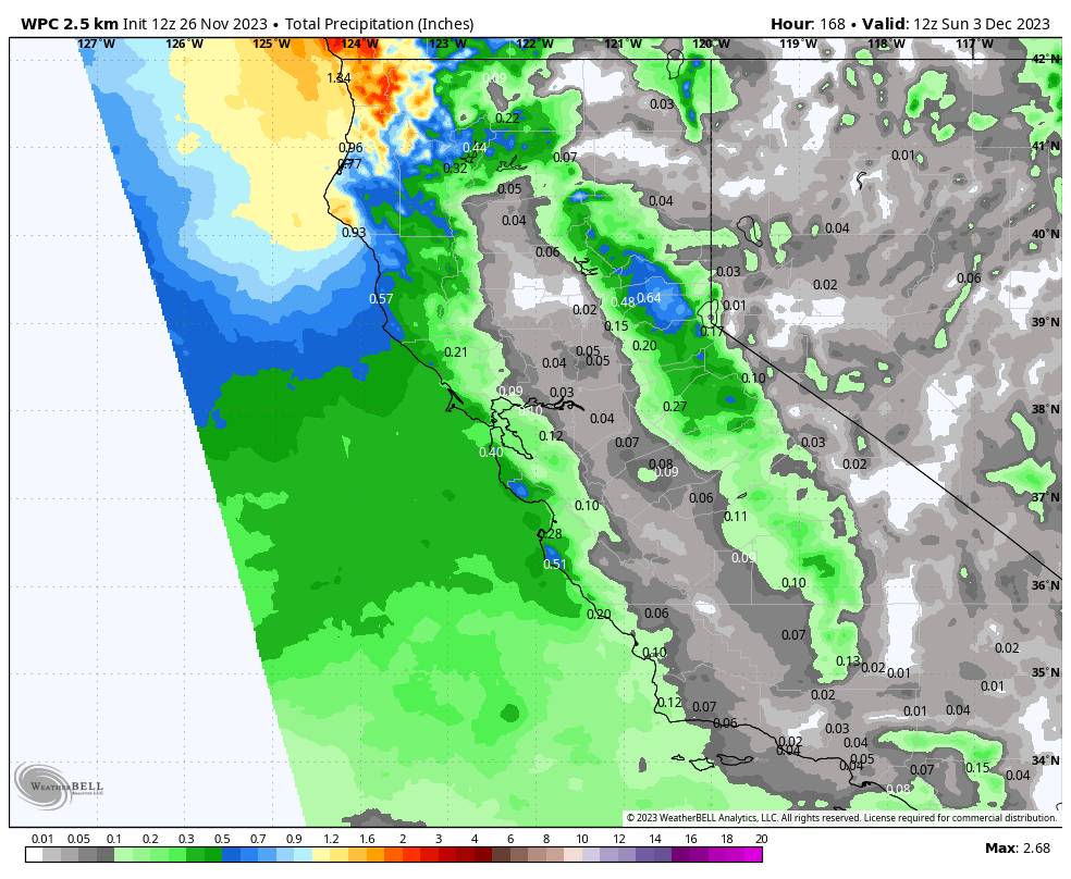
The latest forecast model runs show quite a bit of precipitation for the Pacific NW with lighter amounts farther south into California and the northern Sierra. The good news is that the storms look cold enough for all snow down to the base. Highs should drop into the 30s starting Thursday. These storms don’t look to be overly windy as well.
Based on the latest model runs we would only see an inch or two of snowfall with each system Thursday through Saturday. Maybe totals of 2-4 inches by next Sunday morning the 3rd. We’ll continue to watch the trends all week, and I’ll have a more detailed snowfall forecast for the end of the week through next weekend over the next few days.
Long-Range Forecast:
High pressure is trying to build in near CA next weekend with some models building it in by next Sunday the 3rd into the week of the 4th. That bumps the storm track to our north by next Sunday into the 2nd week of December. Other models are a bit slower and allow another storm to move through northern CA next Sunday and again Monday-Tuesday the 4th-5th as they have a weaker high-pressure ridge building in by then.
Once the storm door opens for several days later this week, the northern Sierra, especially the Tahoe Basin, appears to be the battle line between dry/weak systems and the wetter pattern just to the north. I don’t have any confidence in the forecast at this point. We’ll continue to watch the trends and hope that the storms will reach us for several days.
Beyond the 5th going into the 2nd week of December, the long-range models continue to try and keep high pressure over the West Coast Coast. However, there is a broad trough and strengthening jet stream over the Pacific trying to send storms into the West Coast. So the strength of the high-pressure ridge over the West could make a big difference in the track of the storms and how much moisture we could see reach the northern Sierra.
We’ll continue to watch the trends and hope that more storms than not can bring some snow to the northern Sierra. Hopefully, farther into December the storm pattern will open up more making it easier for storms to move through the region.
BA


