

Wednesday Weather:
We are finishing up a typical April dry period with mostly sunny skies on Wednesday. Highs into the 50s and 60s in the village.
Milder System with Showers:
We have the next system spinning off the coast on Wednesday, and that will slowly move inland on Thursday and Friday. We will see showers increase by Thursday afternoon, with partly sunny skies to start. Highs into the 50s for the lower elevations and 40s for the higher elevations. Snow levels staying mostly above 9000 ft. through Thursday night.
On Friday, as the center of the low passes through, we will see slightly colder air with 40s for highs for the lower elevations and 30s for the higher elevations. The snow levels will drop to around 7500 – 8000 ft. by afternoon. Only scattered and lighter showers are expected through the day on Friday, with some wet snow possible up top.
Colder Weekend Storm:
Friday night into Saturday, a colder and wetter storm moves in from the NW on the heels of the weaker/milder system, with scattered snow showers possibly lingering into Sunday. Strong winds for Saturday with ridgetop gusts from the west up to 50-70+ mph. Highs drop into the 30s for the lower elevations and 20s above 8000 ft. That cold air continues into Sunday with lighter winds.
The latest model runs continue to trend wetter with the weekend storm, showing up to 2-3+ inches of total precipitation falling over the mountain. Most of that falling Saturday and Saturday night as snow levels drop. That makes this a very interesting April storm.
The snow levels are forecast to drop close to the base on Saturday with the steadier precipitation moving in. They could fluctuate between 6000 – 6500 ft. during the day, and the base is near 6000 ft. That would mean wet snow if it does turn to snow. Then snow levels drop as low as 4000 ft. Saturday night with snow for all elevations.
Based on the latest snow level and precipitation forecasts, we could see around 8-16 inches fall near the base by Sunday, depending on how fast snow levels fall on Saturday. For mid-mountain, around 17-23 inches are possible by Sunday, and 22-28 inches up top.
If the latest model runs verify, this storm could be similar to the last one for the upper mountain, but has a shot at being better for the lower mountain if snow levels can fall to lake level Saturday and lower Saturday night. Only expecting a dusting up to a couple of inches at the end on Sunday from any lingering showers.
Long-Range Outlook:
The long-range models continue to show troughing over the region continuing through the 3rd week of April, and I currently don’t see much of a change going into the last week of April either.
We look to see a break in the storms early next week, but it stays cool with highs in the 40s for the lower elevations and 30s for the higher elevations. That colder pattern could last into the last week of April. Sorry for those who were looking forward to the mild March temperatures and skiing in shorts.
The long-range of the operational models shows storms returning by the end of next week, with some fairly wet storms by April standards possible during the 3rd week of April, and possibly into the 4th. The ensemble mean models show above-average precipitation continuing through at least the 22nd.
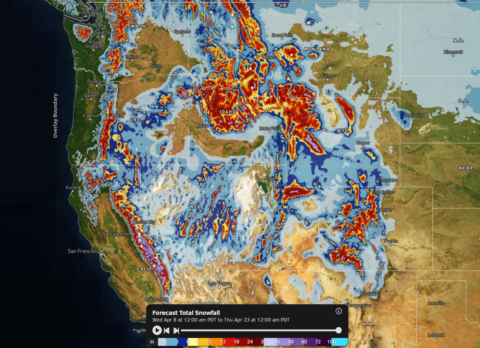
The two-week snowfall forecast map on OpenSnow, for the West, looks like the map we were hoping for in March, but we are getting it in April. We will see rain showers for the lower elevations at times, including this week, but the upper mountain should be able to hold onto snow fairly well by April standards, with a slower melt and adding back some at times…
BA
