Skip to content
palisades tahoe
Explore
Main Menu
  • Explore Palisades Tahoe
  • Discover Palisades Tahoe
  • Our Name Change
  • Explore Legendary Lifts
  • Palisades Tahoe Blog
  • About Lake Tahoe
  • Mountain Safety
Plan Your Visit
Main Menu
  • Lodging
  • Tickets & Passes
  • Lessons & Guides
  • Deals & Packages
  • Rentals & Demos
  • Travel Here
  • Ikon Pass Benefits
Mountain Information
Main Menu
  • Weather
  • Lift Status
  • Webcams
  • Hours of Operation
  • Trail Maps
  • Parking & Road Conditions
  • Snowfall Tracker
Events & Activities
Main Menu
  • Aerial Tram
  • Events Calendar
  • Activities
  • Dining & Apres
  • Shopping
  • Groups, Meetings & Weddings
  • Ski & Snowboard Teams
Summer High Camp Tram with wildflowers.
Basecamp for Lake Tahoe
Palisades Tahoe is the beating heart of Lake Tahoe adventure. Plan your trip with us today.
PLAN YOUR VISIT
Icon / FlashCreated with Sketch.
View All Offers

Windy Monday, Snow Tuesday & Wednesday

  • By Bryan Allegretto
  • Weather
  • Feb 1, 2021

Monday:

For today, we have some clouds streaming in with the moisture plume to our northwest and some moisture streaming into CA to our south from the southern branch of the jet stream. We should see a mix of sun and clouds for most of the day with some gusty winds. Ridgetop winds gusting to 60+ mph. High temperatures in the 30s on the upper mountain and 40s at the base.

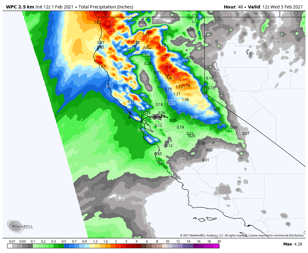
Monday Night – Tuesday Night Storm:

We may see light rain/snow showers reach the mountain by midnight, with the steadier snow holding off until Tuesday morning. Then the heaviest snow is expected during the day on Tuesday as the cold front moves through. We could see snow showers linger into Tuesday evening before ending Tuesday night. Ridgetop winds continuing to gust up to 60+ mph from the southwest Tuesday.

Snow levels could start above the base around 6500-7000 ft. Monday night, but then falling below the base Tuesday morning. Then colder air moves in behind the front Tuesday evening with the snow becoming drier. We could see 5-11 inches of new snow at the base, and 9-16 inches on the mountain by Wednesday morning.

Wednesday System:

We may see some clearing Wednesday morning with ridgetop winds still gusting to 50+ mph. Then we could see increasing clouds and snow showers returning by Wednesday afternoon as a weak system moves through, with snow showers into Wednesday evening. Highs only in the 20s on the mountain Wednesday and 30s at the base.

This system could bring an additional 1-3 inches of snow to the mountain.

Long-Range:

We will see a drier pattern build in starting Thursday through the weekend. Expecting mostly sunny skies with highs in the 30s on the upper mountain and 40s at the base. We could see gusty northeast winds Thursday with gusts up to 40+ mph up top.

The long-range forecast models suggest we could start to see a pattern shift during the 2nd week of February, possibly opening the door to some colder systems moving down from the north from around the 10th – 16th. More on that as we get closer.

BA

Share this article
Picture of Bryan Allegretto
Bryan Allegretto

Recent Posts

  • Weather ·
  • April 30, 2025·

Weekend Snow Showers Possible

There is a chance for high elevation snow showers for the first weekend of May. The mountain is aiming to…
Read more
  • Weather ·
  • April 28, 2025·

11 Inch Weekend Snowfall Total!

Snowfall Report: The weekend storm brought snow down to the base as we expected. We saw several inches accumulate on…
Read more
  • Weather ·
  • April 24, 2025·

Winter’s Quick Return

All of the focus this week is on winter’s last gasps over the weekend, as snow showers and low snow…
Read more

Social

Instagram Twitter Facebook Youtube

Contact

   Email Us
   1.800.403.0206

Our Partners

U.S. Forest Service Logo
1960 Olympic Valley Road
Olympic Valley, CA 96146

©2025 Palisades Tahoe

Alterra Mountain Company
  • Privacy Policy
  • Terms of Service
  • Photo Upload Terms of Use
  • Accessibility
  • Do Not Sell My Personal Information
  • Privacy Policy
  • Terms of Service
  • Photo Upload Terms of Use
  • Accessibility
  • Do Not Sell My Personal Information