

Wednesday – Friday Weather:
We have inversions that set up Tuesday night and will likely the rest of the week. That brings warmer temps to the higher elevations overnight and fog to the valleys. We will likely see this each morning. Above the fog mostly sunny each day through Friday, and partly sunny below the fog. Highs in the 40s to near 50 degrees down at the base.
Weekend Storms:
We are going to catch the southern edge of mostly storms starting Saturday. The Saturday system looks to have a better shot of digging a little farther south with the steadier precipitation near the Tahoe basin. Sunday we will likely see some clouds with a chance for some showers.
Highs in the 30s for the upper mountains and 40s for the lower elevations for the weekend. Ridgetop winds gusting up to 80-100+ mph Saturday, likely closing a lot of upper mountain ski lifts. 40-50+ mph gusts are possible for Sunday.
Snow levels will depend on how far south the heavier precipitation falls, as heavier precipitation rates drag down snow levels. If we stay light snow levels may only dip as low as low as 7500-8000 ft. If we see some heavier preciptiation Saturday they could dip as low as 6300-6800 ft. for a few hours. Then Saturday night through Sunday night with scattered showers likely up around 7800-8800 ft.
That means a windy and wet day at the base on Saturday and then breezy and a little less wet on Sunday. Rain is likely on the lower mountain as well, with wet snow for the upper mountain, but with the strong winds on Saturday, it will be hard to get up to where it’s snowing. We could see up to 1-4 inches of snow up top over the weekend, with most of that falling Saturday.
Monday System:
Showers from the next system could move in after midnight Sunday night and are possible into Monday evening. Highs in the 40s for Monday. The winds don’t look that strong with this storm.
Snow levels look to be very high, possibly around 8000 ft. to start but rising up to 10,000-11,000 ft. during the day on Monday and staying there into Monday night. So we are mainly expecting rain up to the peaks with this system.
Christmas Eve Storm:
We finally see a trough split off from the mean trough over the northeast Pacific and dig farther south into CA on Tuesday. That will allow the next storm to dig farther south and bring in colder air during the storm for snow to the base. This storm looks fairly strong with a decent moisture tap as it moves inland on Tuesday.
We could see precipitation push in after midnight on Monday night and continue through the day on Tuesday and into Tuesday evening. The storm should clear out into Christmas Morning on Wednesday. Highs in the 30s for Tuesday with strong ridgetop winds gusting up to 70-90+ mph from the southwest. A classic Tahoe storm day.
This system is still outside of my 5-day forecast window threshold for getting into the finer details of potential snowfall. Snow levels will likely start high early Tuesday morning but fall through the day and drop below the base by the end of the day. The upper mountain could see over a foot of snow with several inches of snow possible down to the base by Tuesday night.
Long-Range Forecast:
Christmas Day could start cold with clear skies and lighter winds. I’d get on the hill early if you’re skiing as milder air may flow in later in the day as we transition right back into a milder active storm pattern by the 26th.
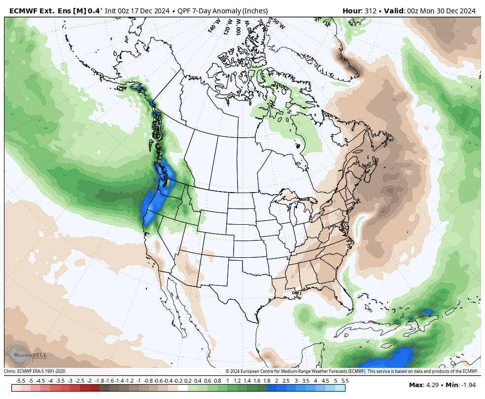
From the 26th through about the 29th-30th, the long-range models continue to show a strong +EPO pattern featuring a large trough in the northern Pacific into the Pacific NW and a strong jet stream underneath aimed at the West Coast, helping to push storms inland. The storm track may be just far enough south to bring a wet pattern to the northern Sierra through the period.
We will still be on the southern edge of this active pattern into the Pacific NW. That means that storms will continue to be a pain to forecast for precipitation totals. A slight jog north and storms are drier and a slight jog south and then can be much wetter down into the Tahoe basin. Overall it would be back into a milder storm pattern.
By the end of the month into the first few days of January, the +EPO pattern is forecast to drop back negative with high-pressure building in farther west over the West Coast as the strong Pacific jet stream retracts. We’ll continue to watch the long-range patterns to see when the pattern could open up to colder storms in January.
BA
