

Saturday:
Clouds and winds increase again Saturday with scattered snow showers. Ridgetop winds increase up to 60-70+ mph from the southwest which will affect some upper mountain lifts. Snow levels could hover near the village through Saturday afternoon, so some rain could mix into any showers we see. Only expecting a dusting to an inch of snow on the mountain by the end of the day.
Later Saturday evening into Sunday morning we expect some steadier snow and falling snow levels as the next system moves through. Then scattered snow showers are possible for Sunday afternoon into Sunday evening. We could see an additional 2-5″ at the base and 4-8″ on the mountain by Sunday morning.
Sunday:
Ridgetop winds could continue to be fairly gusty Sunday with gusts up to 70-80+ mph from the southwest through Sunday morning and then possibly dropping to 40-50+ mph by the end of the day. That could affect some upper mountain lifts again, at least through the morning. Highs in the 30s at the base and 20s up top both days. Maybe an additional 1-3″ of snow on the mountain during the day Sunday.
Sunday evening we could see just scattered snow showers with a bit of a lull between storms. Sometime after midnight into Monday morning, the next storm moves in with heavier snow. Depending on the timing we may only see light snowfall Sunday night, or several more inches by daybreak Monday.
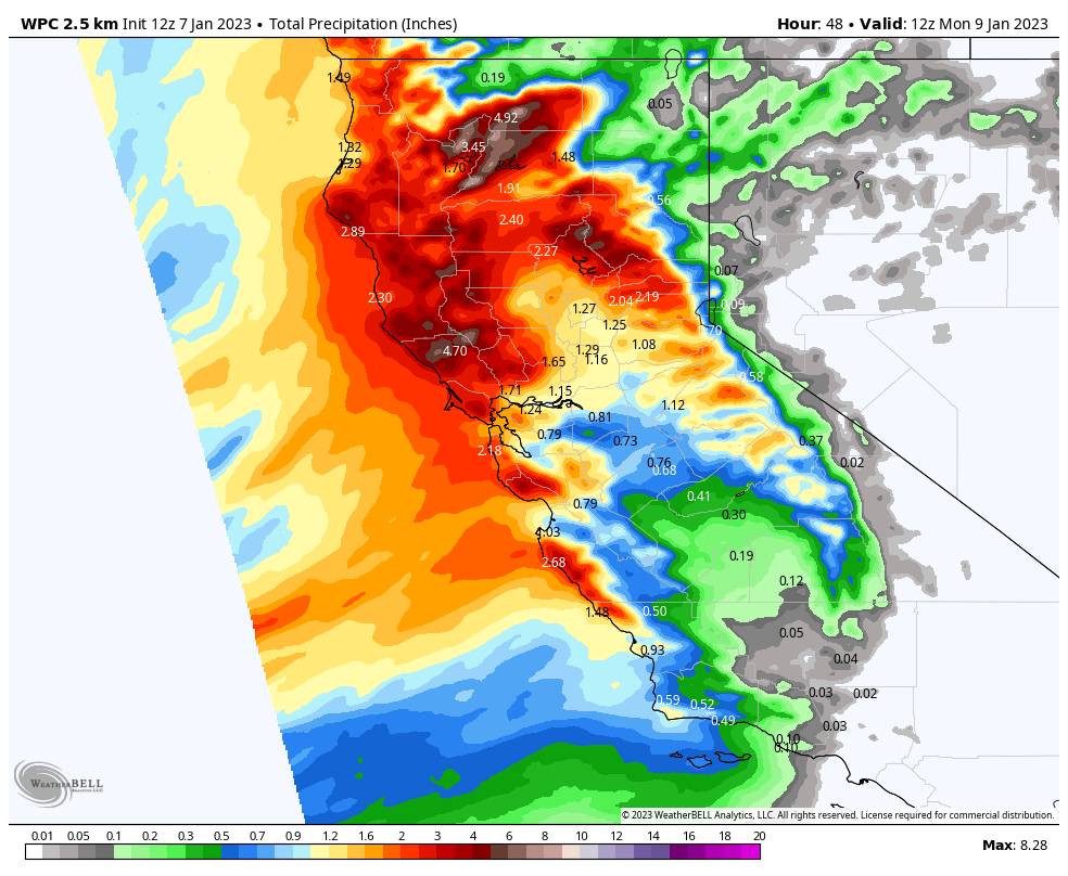
Here is the updated snowfall forecast for the weekend through Sunday night, for 2-day totals expected by 6 AM Monday:
- 5-11 inches at the base.
- 10-15 inches at the mid-mountain elevations.
- 12-17 inches on the upper mountain.
Monday – Tuesday Storm:
The next storm moves in by Monday morning and lasts into Tuesday evening. This storm starts warmer and is wetter. Snow levels look to peak out around 7000-7500 ft. Monday afternoon/evening with heavy rain at the base & heavy wet snow on the upper mountain. Ridgetop winds gusting from the southwest up to 100+ mph Monday which will likely close several upper mountain lifts.
Snow levels could drop below the base by midnight Saturday night, and below 5000 ft. through the end of the storm Tuesday evening. That means we could see heavy snow from top to bottom into Tuesday morning. By Tuesday morning, we could see 1-2 feet at the base, 2-3 feet at mid-mountain, and 3-4 feet up top.
The heavier snow could linger into Tuesday morning, then lighter snow Tuesday afternoon becomes more scattered Tuesday evening before tapering off Tuesday night. Several more inches of snow is expected Tuesday into Tuesday evening.
The winds could be gusting up to 60-70+ mph up top Tuesday morning with gusts of only 40-50+ mph by the end of the day. That could cause lift opening delays, along with waiting for mountain ops to dig out and perform avalanche controls. Highs in the 30s at the base and 20s up top.
For the snowfall forecast, the upper mountain where we see all snow is easier to forecast. At the base, the snowfall forecast could be off a bit if it rains longer Saturday night, or a bit too low if rain turns to snow faster. Here is the updated 2-day snowfall forecast for storm totals expected by Wednesday morning.
- 24-32 inches at the base. (after a change to snow Monday night)
- 32-52 inches at the mid-mountain elevations. (a bigger range as rain turns to snow higher up first)
- 51-61 inches up top.
Long-Range:
We may see a break in the storms for Wednesday – Thursday with partly sunny skies. Then storms could return by the 13th and continue into the week of the 16th. The storms could be a little colder through the 3rd week of January. More details as we get closer to each storm.
The long-range models suggest we could possibly transition into a drier pattern for the last week of January, which may be a nice break if it happens after almost non-stop storms since the beginning of November. But we don’t want too long of a break…
BA

