

Snowfall Report:
1-3 inches of new snow fell Saturday night. The mountain was shadowed from some of the heavier snow on the east side of the Tahoe basin with the flow from the northeast. That brings the upper mountain 2-day storm total to 12 inches.
That is right in line with the 12-17 inches expected with this storm, and we could pick up a final inch or two of snow Sunday morning as the snow was still falling after the 5 AM measurement. The final total for March is 153 inches, which is well above average for the month!
Sunday Weather:
The band of snow that moved through overnight will continue to slide south of the region on Sunday. We will see a break with the sun coming out as we go through the day. The latest model runs are showing scattered snow showers popping up during the afternoon with the daytime heating. Highs in the 30s with gusty NE winds over the ridges up to 30-40+ mph.
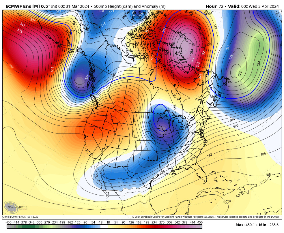
Monday – Wednesday Weather:
Monday through Wednesday high pressure builds in over CA. That will bring a drier and milder pattern. Mostly sunny skies each day with highs into the 40s on Monday, and then 50s on Tuesday and Wednesday. Around 10 degrees cooler up on the peaks.
Gusty NE winds could continue on Monday. Then increasing winds on Wednesday and some increasing clouds by late afternoon ahead of the next storm. Ridgetop gusts from the southwest up to 60-70+ mph by evening, so some upper mountain lifts could close before the end of the day.
Wednesday Night – Friday Storm:
The latest model runs show the leading edge of the precipitation with the cold front associated with the next system reaching the northern Sierra Wednesday evening. A band of steadier precipitation is possible Wednesday night and then showers are possible Thursday and Friday as low pressure spins down the coast and slowly moves through CA.
High temperatures drop into the 30s. Gusty winds continue Thursday, and then lighter winds for Friday. Snow levels look to start very high Wednesday evening, up around 9000 ft. Then falling to around 6300-6800 ft. behind the front by Thursday morning. That means rain to start for most elevations and rain possibly continuing near the base.
Then on Thursday, colder air continues to filter into the region with snow levels dropping down near the base, around 5500-6000 ft. by Thursday afternoon, and dropping well below the base Thursday night. By Saturday morning we could see snowfall totals of around 2-5 inches near the base, 3-7 near mid-mountian, and 5-9 inches up top.
Most of the snow is expected to fall by Friday morning, with lighter and scattered snow showers being shown for Friday. The snowfall forecast is for a 2.5-day period, so only light amounts are expected each day with no deep days expected right now, but we’ll watch the trends over the next few days.
Next Weekend:
Troughing with colder air and unsettled weather are still forecast to hang around through Monday the 8th. Another weak system could drop in for Saturday, and a final weak system could move through Sunday into Monday. Highs likely remaining in the 30s with partly sunny skies possible between systems and snow showers.
As of right now, these systems look to bring snow showers but nothing significant as far as snowfall. We’ll continue to watch the trends all week.
Long-Range Forecast:
The long-range models continue to show high-pressure building in over the West starting around the 9th through mid-month. That should begin a drier a milder pattern. It is always possible that we get brushed by a storm moving through to our north.
We’ll continue to watch the trends through the end of April and into May to see if winter will try to show up again.
BA
