

Over the past 24 hours, the Thursday storm has been trending colder, which could mean more snow than previously predicted. Let’s get into the latest details as of Sunday night.
We will have dry weather through Wednesday ahead of the storm, with highs into the 50s to near 60 degrees at the base.
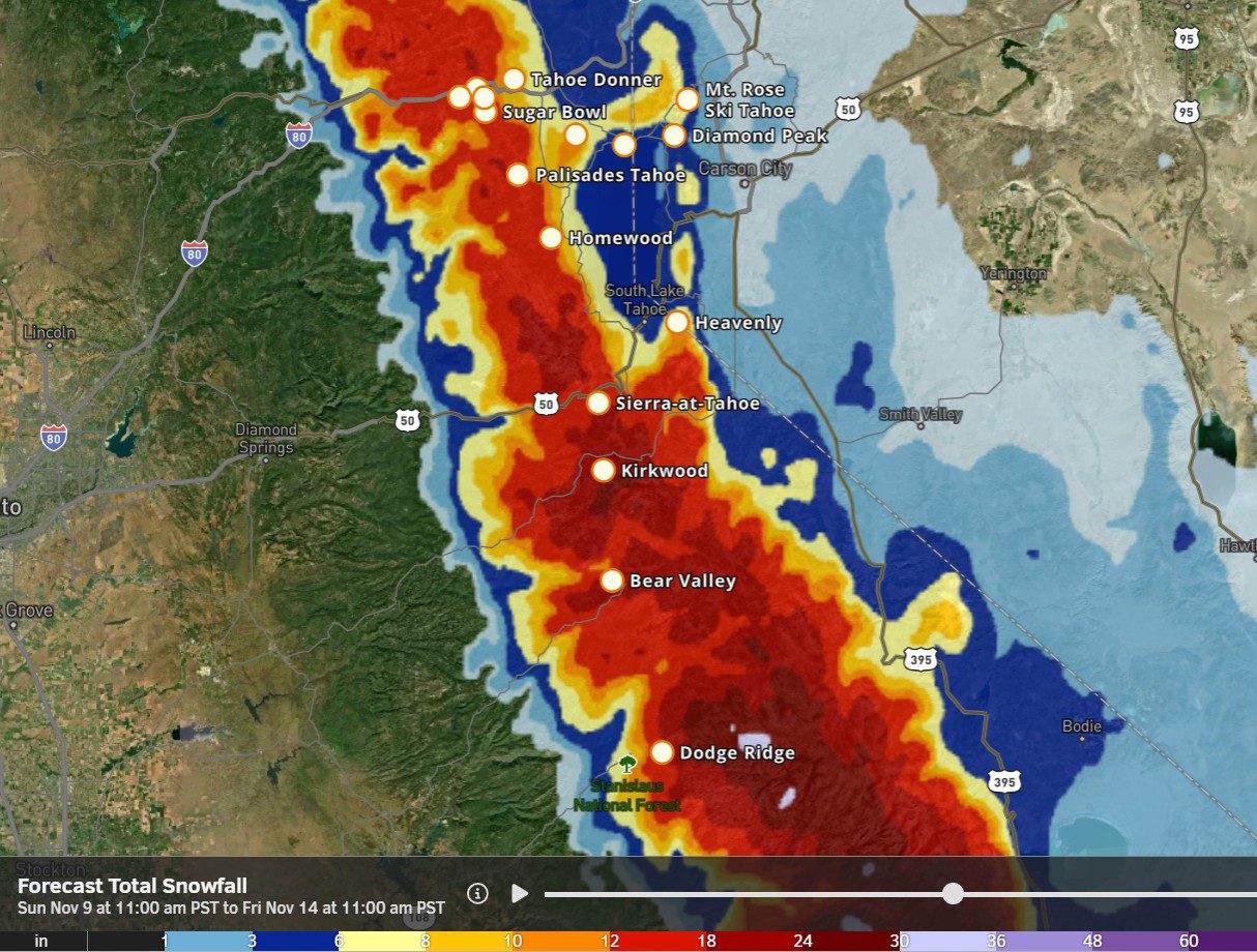
Thursday Storm:
The latest trends are for a one-day storm from Thursday morning into Thursday evening, and clearing out Thursday night. A storm in the northern Pacific is going to pick up a low-pressure system stalled NE of Hawaii that is drawing up subtropical moisture, which will help to draw more moisture into the system as it pushes into CA on Thursday.
This is the same scenario that we have been tracking all week, with up to 2 inches of precipitation falling on the mountain by early Friday morning.
The latest model runs are now trying to dig the trough and colder air farther south and into CA faster during the day on Thursday. Snow levels start very high, above 8500 ft. early Thursday morning. But could fall to near the base by midday, and even lower Thursday night. We will have to see if this much colder air scenario holds over the next few days…
If the colder air can outpace the heaviest precipitation, we could be talking about a decent snowstorm for most elevations on Thursday into Thursday evening, which clears by early Friday morning. The latest trends suggest up to 5-10 inches of snow at the base, 9-14 inches near mid-mountain, and 12-18 inches up top.
We will be watching closely to see if this new scenario pans out over the next few days. I will be traveling all day on Monday from 3 AM through the evening, so I won’t be able to post again until Tuesday morning. That gives us 36 hours to see how this storm trends.
Next Weekend:
Drier weather for next weekend, but colder behind the storm. We could see some scattered showers on Friday and then partly-mostly sunny skies for Saturday and Sunday, the 16th. Highs in the 30s on the mountain and 40s for the lower elevations near the base.
Long-Range Forecast:
The long-range models have shifted a bit as well. They still show a trough around the 17th that could allow in a colder/weaker system with snow showers around the 17th, and then they now show the ridge staying a bit farther off the coast through the 24th.
That could be enough to keep a colder northerly flow into the region through the long-range, and a better chance for storms to dig a bit farther south with more rain and snow for the northern Sierra. The ensemble mean models went from below average precipitation forecasts, to near to slightly above average now beyond the 17th.
Even if we don’t see any big storms, we should be in a colder weather pattern for a while, which should bring us some better snowmaking weather.
BA
