We are getting closer to an active pattern returning, one that could bring significant snowfall to the mountains over time. We just have to get past a few more days of dry and mild weather.
Monday – Thursday Weather:
High pressure will be over the West through Thursday. We will see mostly sunny days with highs near 60 degrees at the base and 50s on the mountain, with 40s at the highest elevations through Thursday.
Weekend Storms:
By Friday, the pattern is shifting with the ridge moving east and the eastern Pacific trough pushing its way into the West Coast, opening the storm door. The weather will start to change on Friday, with cooler temperatures in the 40s and increasing clouds and winds later in the day, as the first storm approaches.
The latest forecast model runs are in disagreement on how well this first storm holds together as it tries to push a front and precipitation through the northern Sierra Friday night. The European model is holding it together pretty well with a nice shot of rain and upper mountain snow.
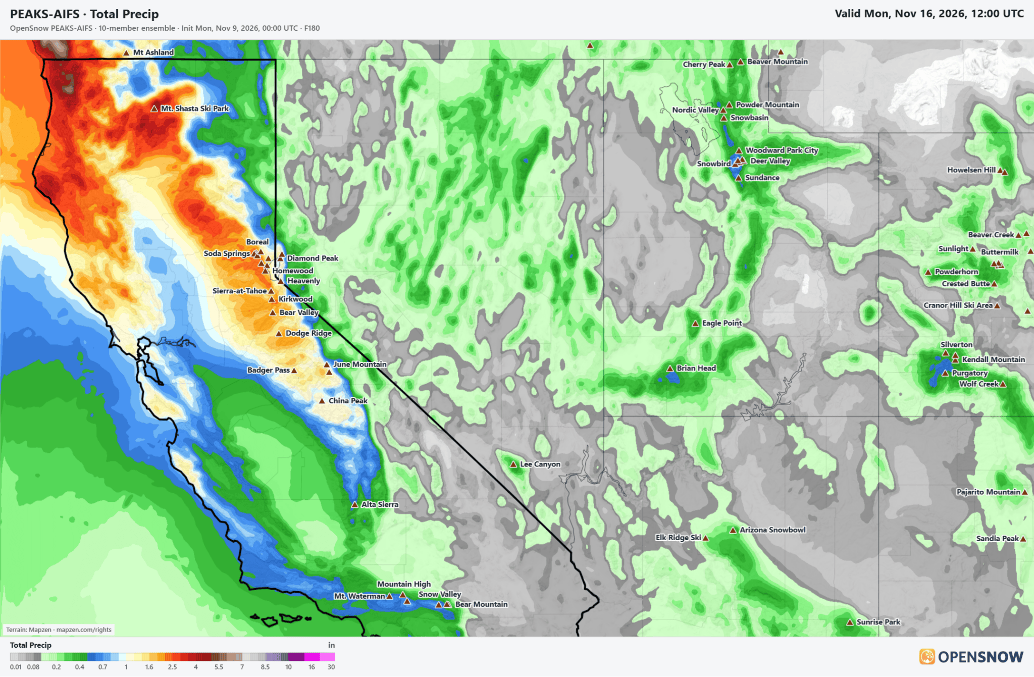
Colder for the weekend and windy, with a possible break between storms on Saturday, and then another storm could move through on Sunday. The latest model runs show up to 1-2 inches of total precipitation possible over the northern Sierra by next Monday morning.
The snow levels look to fluctuate around 7000 ft. through the weekend, and then fall behind the storms next Monday. That means we will likely see mainly rain near the base and the base through the weekend, and snow on the upper mountain.
The latest forecasts would bring several inches of snow to the upper mountain by next Monday, with up to a foot or more possible if the wetter model runs come to fruition. I’ll be putting out a more detailed snowfall forecast for each elevation as we get closer to the weekend, as I usually do within 5 days of storms.
Long-Range Outlook:
The long-range models show lower heights and an open storm door through the 3rd week of November. The precipitation anomaly forecasts continue to show a wet pattern. We won’t know the specifics on storms, timing, and possible totals until we get closer, but it’s a good sign that storms could continue next week.
The temperatures and snow levels look colder/lower as well next week. Hopefully that means if we see additional storms, we will see snow pile up lower in elevation, and continue to pile up on the upper mountain. We should also see better snowmaking conditions to add to what the storms deliver.
We are still always wary of any forecasts beyond 5-7 days, but it’s a good sign for now, and the models have been showing this for a while now. We will continue to watch the trends. Let’s hope storms start to deliver this weekend and beyond so that we can build a good base in time for opening day.
BA