

Thursday – Friday Showers:
As of 7 AM, we are seeing ridgetop winds gusting up to 80+ mph over some exposed peaks, temperatures in the 30s, and snow levels up around 7500-8000 ft. There precipitation on the southeastern edge of the storm near Tahoe has been slow to push in so far.
We expect showers to increase through Thursday afternoon, with the steadiest precipitation expected later in the day. Then scattered showers Thursday night into Friday evening. Highs in the 30s. Ridgetop winds gusting up to 70-90+ mph from the SW on Thursday. Then lighter winds for Friday.
The snow levels are slow to fall. They could be around 7300-8300 ft. by midday and 6000-7000 ft. by evening. Then bottoming out around 5000-6000 ft. early Friday morning before rising back up to around 6300-7300 ft. by the end of the day. Then back to lake level with any lingering showers Friday evening.
By Saturday morning, storm totals could be a coating up to 2 inches of snow near the base with some rain possible Thursday & Friday afternoon, 1-4 inches near mid-mountain, and 2-6 inches up top.
Saturday Weather:
A break between storms Saturday with mostly sunny skies and highs warming into the 40s for the lower elevations.
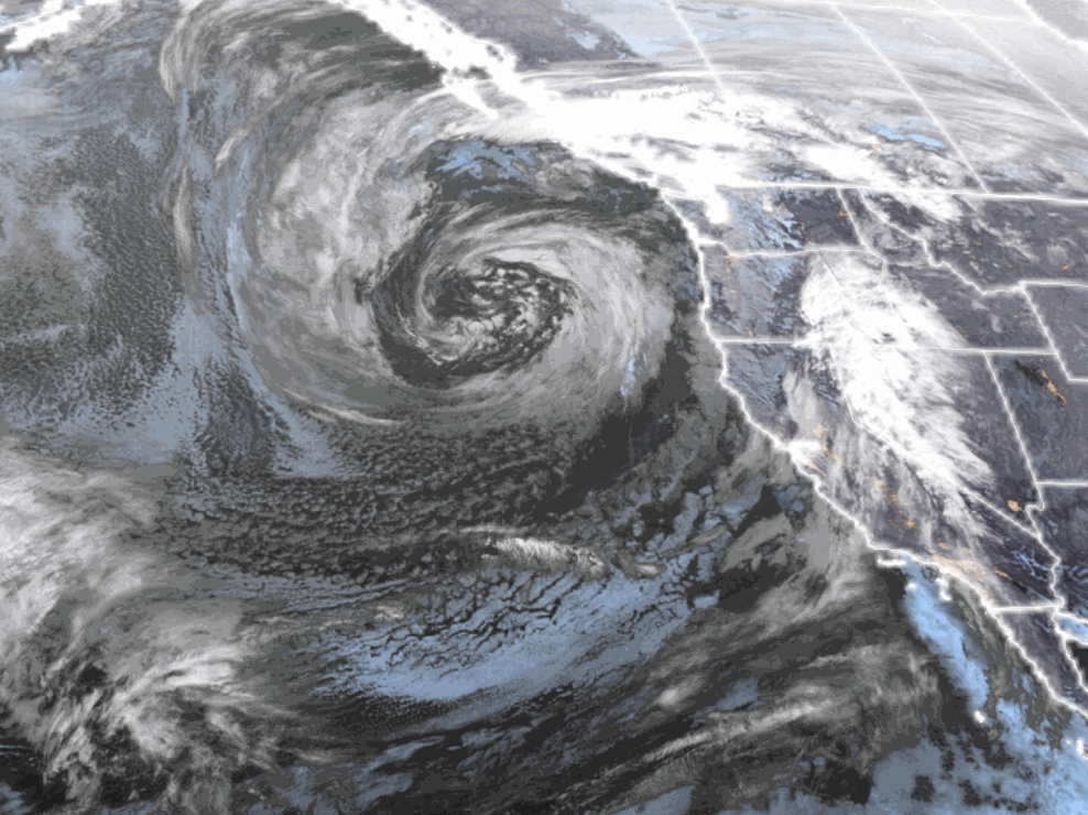
Sunday – Monday (Tuesday) Storm:
There is decent forecast model agreement on Sunday and Monday, and then they diverge by Tuesday. We will see a large low-pressure system spinning in the Northeast Pacific Sunday through Tuesday, with the first wave moving in Sunday morning and another for Monday.
The first system moving in on Sunday looks weaker, with showers into Sunday night. The secondary wave for Monday looks wetter with some steadier rain & snow. Highs in the 30s. Ridgetop winds gusting up to 40-60+ mph from the SW by Sunday evening and then 70-90+ mph for Monday.
Snow levels will be fluctuating through the 2-day period. Starting around 5500-6500 ft. Sunday morning and then rising up to 6500-7500 ft. by Sunday evening, and staying in that range Sunday night. Monday, with the heavier snow moving through, snow levels could drop to around 5300-6300 ft. and lower at the end Monday night.
That means we could see a few flakes to the base Sunday morning but mostly rain showers through Sunday night, and then steady wet snow during the day on Monday. The upper mountain will see mostly all snow above 7000 ft. Snowfall totals by Tuesday morning could be around 7-13 inches at the base and 13-22 inches above 7000 ft.
More Storms Possible:
We will continue to watch the trends for Tuesday to see if we will get a break or another day of snow showers with several more inches being added on top for the mountains.
The storm door stays open through at least Thursday. The GFS model holds that low-pressure system off the coast on Tuesday and has it tapping into lots of Pacific moisture with a fairly strong AR for this time of year aimed at the Sierra by Wednesday.
That scenario is skewing the snowfall forecasts to show feet of snow next Wednesday on the automated forecasts, so take those with a grain of salt. The European and other models show a break between storms on Wednesday, with a smaller system moving through next Thursday the 3rd. More details as they become clearer.
Long-Range Forecast:
Next Friday, some lingering showers are possible, but we could see clearing with high pressure building in over the West Coast by Saturday the 5th bringing us a drier pattern.
The ensemble mean models show weak low pressure or weak high pressure over the West Coast from the 6th through mid-month. That leaves the door open to weak systems brushing us. Some of the operational models show weak systems possible, while others bump the storm track north with a drier pattern.
Overall, it looks like the bigger storms could be done for a while or the season after next week. We’ll continue to watch for late-season storms through April.
BA
