

Monday – Tuesday Weather:
We have another day of nice weather for New Year’s Day. Monday will be mostly sunny with highs into the 30s on the mountains and near 40 degrees at the base. Tuesday we should see similar temperatures. We could start with partly sunny skies, and then increasing clouds through the day. Ridgetop winds gusting up to 30-40+ mph from the south-southwest by evening.
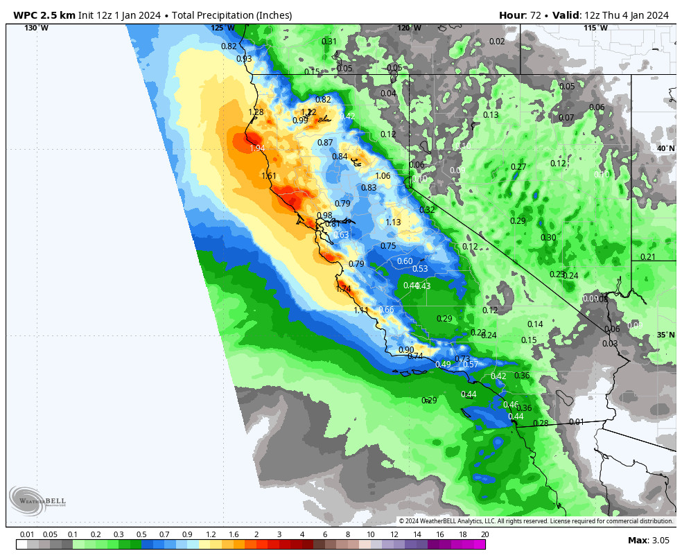
Tuesday Night – Wednesday Storm:
The next system moves in Tuesday night. The latest forecast model runs show precipitation reaching the mountain between 7 PM – 1 AM, with steadier snow expected into Wednesday morning. Then we could see scattered showers through the afternoon that diminish into Wednesday night as the southern half of the splitting system drops south away from the region.
We will start with southerly flow Tuesday night with the precipitation struggling to push in over the mountains, but the latest model runs show the flow turning more toward the southwest early Wednesday morning, which may give a little push to the east.
The snow levels could start just above the base around 6500-7000 ft. Tuesday night, but look to fall to the base fairly quickly by early Wednesday morning, and drop near to just below 5000 ft. during the day on Wednesday.
My snowfall forecast has increased about 2 inches on the high-end due to the trend toward a bit more precipitation making it over the mountains Wednesday morning. We could see 2-5 inches near the base and 3-7 inches on the upper mountain by Wednesday night.
Thursday:
We will clear out on Thursday with partly sunny skies and highs in the 30s.
Friday System:
The latest model runs show the next weak system dipping far enough south now to bring us some snow showers on Friday. The precipitation amounts look pretty light as most of the moisture stays up into the Pacific NW.
We could see snow levels rise a bit with some warmer air ahead of the system, with some rain showers possibly mixing in near the base up to 6500 ft. Friday morning, and then snow levels fall through the day and into Friday night. We could see a dusting up to 2 inches of snow on the mountain Friday and another dusting to an inch Friday night.
Saturday Storm:
This storm could be the coldest wet storm we’ve seen yet this season with good forcing and the cold air helping with orographic enhancement over the mountains and increased snow:liquid ratios. The ingredients we want for a decent snowstorm. Not huge but decent compared to what we’ve seen so far this season.
The one thing we’ll have to watch is how far west the storm digs as it moves inland, as high pressure is building in right behind the trough in the eastern Pacific as you can see on the map above, and if the storm drops into the CA farther east over land, it could be drier than if it digs farther west.
Right now, we are expecting a windy and snowy day on Saturday from this fast-moving storm. We could see snow move in early Saturday morning and move out by early Sunday morning. Ridgetop winds from the west up to 60-70+ mph which could close some upper mountain lifts. Highs drop into the 20s.
The snow levels will be plenty low as they should stay below 5000 ft. from Friday night through Saturday night, and could dip close to 2000 ft. by the end! Snow ratios will be higher with the Saturday storm, and could average around 15:1 near 8000 ft., which would bring powdery snow to the upper mountain.
The latest model runs have a BIG range of solutions for snowfall. Anywhere from a high end of 8 inches up to 34 inches in total for Friday through Saturday night. We need to iron out the details of the storm track over the next few days. Taking the model average today, we could see 9-14 inches at the base and 14-20 inches on the mountain.
Long-Range Forecast:
We should see cold but drier weather for Sunday into early next week, with partly-mostly sunny skies.
We continue to have differences in the models beyond Sunday, as some models dig the western trough farther west the 2nd week of January with a weaker storm dropping down from the north on the 9th and a wetter system on the 10th.
Other models show the eastern Pacific ridge closer to the West Coast with the troughs farther east, and CA on the western edge. They show weaker moisture-starved systems dropping down from the north if any during the 2nd week of January, and below-average precipitation.
We’ll continue to watch the trends for the pattern during 2nd week of January as well.
BA
