

Snowfall Report:
The snow showers on Friday dropped a final 3 inches up top with another dusting near the base. That brought the 2-day storm total to 4 inches up top, and the March snowfall total to 82 inches and counting!
Saturday Weather:
We have a quiet day for Saturday between storms, so get out and enjoy the break between storms. Mostly sunny skies are expected with highs in the 40s and lighter winds.
Sunday – Tuesday Storm:
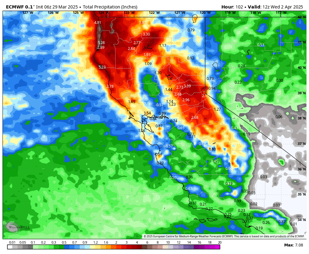
The next storm is off the coast and quickly approaching. Clouds increase Saturday night, and we could see scattered showers reach the mountain after midnight, with showers increasing during the day on Sunday.
Highs in the 30s on the mountain for Sunday and into the low 40s near the base. Ridgetop winds increasing with gusts up to 50-70+ mph from the SW over the ridges, likely closing some ski lifts. Snow levels start near the base Sunday morning and then rise to around 6800-7300 ft. by evening.
The biggest push of moisture over the Sierra is expected during the day on Monday, along with colder air. The snow levels should be back to the base by Monday morning and then continue to fall. Highs in the 30s for the lower elevations and dropping into the 20s above 8k’. Ridgetop winds gusting up to 70-90+ mph.
The center of the low moves through northern CA on Tuesday, keeping the snow showers going, with the storm finally winding down Tuesday night. Ridgtop gusts form the west up to 40-60+ mph on Tuesday, with highs in the 30s for the lower elevations and 20s for the higher elevations.
We could see several inches of snow on the mountain each 12-hour period, with up to a foot+ on Monday. Rain for the base Sunday into Sunday night, and then snow Monday and Tuesday. By Wednesday morning, the 3-day storm totals could be around 19-25 inches at the base, 24-31 inches near mid-mountain, and 29-36 inches up top.
Wednesday – Friday Forecast:
The forecast models are all over the place with what happens behind the storm. There is a chance that a low-pressure system moves from north to south down the West Coast over the 3 days with a chance for scattered showers each day, and maybe the best chance is on Friday as the low is the closest to the region.
Overall, we could see partly sunny skies each day with some clouds and a few snow showers around, especially over the mountains. Highs are in the 30s to near 40 degrees down at the base. We will have lighter winds through the period.
We’ll continue to watch the trends to see if we could trend towards a drier forecast or possibly a bit wetter with a bit more snow on Friday. As of right now it looks like only a dusting to an inch of snow possible each day at best.
Drier & Milder Pattern:
High pressure is still forecast to build in over the region next weekend. That should bring us a drier pattern with mostly sunny skies each day. High temperatures warming into the 40s for the weekend and maybe into the 50s for the lower elevations by Monday – Tuesday, the 7th – 8th.
Long-Range Forecast:
The long-range models show additional troughs possibly swinging through the West Coast during the 2nd week of April. That could open the door to weak systems that could bring us rain and snow showers, especially during the afternoons with the high sun angle and daytime heating.
We’ll keep an eye on the long-range to see if we could pick up any more significant snowfalls through the end of April.
BA
