
Snowfall Report:
6 inches at the base and 8 inches of new snow up top from the cold system that moved in Sunday night. That brings the 3-day total to 12 inches and the season total to 115 inches.
Monday:
Cold Monday with highs in the 20s and scattered snow showers. We could see another inch or two from snow showers later in the morning through the afternoon.
Tuesday – Thursday Storm:
We will likely see a break Monday night through the day on Tuesday. We could see partly sunny skies in the morning and increasing clouds through the afternoon. Highs in the 20s at the base and teens up top.
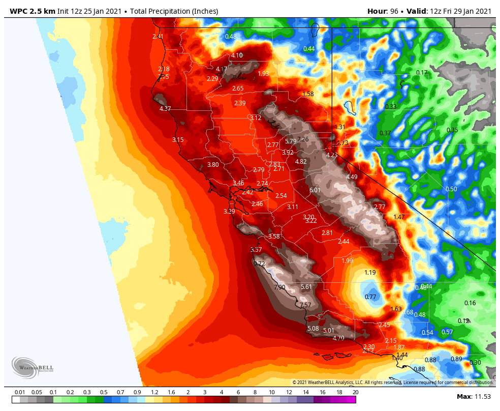
A strong storm will be taking a position off the West Coast Tuesday night into Wednesday and will direct a stream of heavy precipitation into the Sierra. That will bring moderate-heavy snow Tuesday night into Wednesday. Snow levels look to stay below the base along with strong winds up top gusting to 90+ mph. We could see 1-2 feet of new snow on the mountain by Wednesday evening.
The question is then what happens with the atmospheric river aimed at the Sierra. The latest model runs suggest the moisture plume shifts to the south of Tahoe Wednesday with lighter snow, and then they shift it back north with heavy snow again for Wednesday night into Thursday. Then light-moderate snow Thursday night, with snow showers possibly lingering to Friday morning before the system moves east.
If we see the AR shift back north as the latest models suggest, we could see another 2-3 feet of new snow. So we will have to watch the trend on the models closely to see what happens with the position of the heavy precip streaming into the Sierra. By Friday morning we could see totals of 2-3 feet at the base, and 3-5 feet on the mountain. If the AR stays south Thursday we will see the lower end of the forecast.
Friday Night – Saturday System:
We should see a break Friday afternoon with some clearing and lighter winds. Then a much weaker system could move through Friday night into Saturday. Early estimates are for an additional 3-6 inches of snow on the mountain.
Travel & Road Conditions
During this storm cycle, be sure to check the weather forecast and road conditions before traveling to or around the area. Winter driving conditions in the Sierra can change rapidly, leading to whiteouts, snow and ice on roads, and traffic delays.
- To view highway webcams, closure, chain control, and incident information in California, use the Caltrans Quickmap Website & App
- To view highway webcams, closure, chain control, and incident information in Nevada, use the NV Roads 511 Website & App
- To check the status of California highway closures, use Caltrans Highway Status
- For updates on Alpine Meadows Road status, please check our @squawalpineops Twitter feed
It is always best to plan your travel before winter storms move in, or once they have cleared up. If you simply must travel during an extreme weather period, here are some things to remember.
- Have extra water, food, necessary medication, and warm clothing in the car with you. Be prepared to be waiting for long periods of time.
- Carry chains and know how to use them.
- Do not leave the area without a full tank of gas.
- Become familiar with this list of Winter Driving Tips.
Operational Impacts
Due to high winds and heavy snowfall, expect impacted operations and potentially delayed chairlift openings throughout and following the storm cycle. Be sure to check the Squaw Alpine mobile app, website, or @squawalpineops Twitter for real-time status updates before you visit.
Please remember, indoor capacity remains limited due to Covid protocols, so please be prepared to spend extended periods of time outdoors in the cold if you plan to visit the mountains during this storm.
Long-Range:
We may not see much of a break Saturday night before another stronger storm could move in Sunday into next Monday, and a final system is possible next Tuesday. We will be tracking each system and fine-tuning the snowfall and details as we get closer.
We may see a drier pattern build in starting around the 4th.
BA


