Skip to content
Palisades Tahoe Logo Palisades Tahoe Logo Palisades Tahoe Logo
Explore
Main Menu
  • Explore Palisades Tahoe
  • Base to Base Gondola
  • Our New Name
  • Explore Legendary Lifts
  • Palisades Tahoe Blog
  • About Lake Tahoe
  • About Us
Plan Your Visit
Main Menu
  • Tickets & Passes
  • Lodging
  • Lessons & Guides
  • Deals & Packages
  • Rentals & Demos
  • Travel Here
  • Getting Around
Mountain Information
Main Menu
  • Snow and Weather
  • Lift and Grooming Status
  • Webcams
  • Hours of Operation
  • Trail Maps
  • Parking & Road Conditions
  • Snowfall Tracker
Events & Activities
Main Menu
  • Events Calendar
  • Activities
  • Dining & Apres
  • Shopping
  • Things To Do In Lake Tahoe
  • Groups, Meetings & Weddings
  • Ski & Snowboard Teams
IKON PASS HOLDER LODGING DISCOUNT

Ikon Pass holders save up to 20% on slopeside lodging at The Village at Palisades Tahoe.

SLOPESIDE LODGING
Icon / FlashCreated with Sketch.
View All Offers
  • Weather

Snow Showers & Colder Friday into Saturday

  • Mar 4, 2022
  • 6:32 am

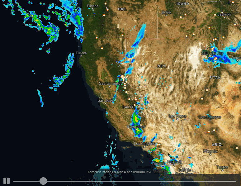
Friday – Saturday Snow:

Snow showers are moving in early Friday morning. We will have scattered snow showers over the mountain throughout the day on Friday. Highs into the 30s. Ridgetop winds from the southwest gusting up to 50+ mph up top by the end of the day. Snow levels should be near to below the base through the afternoon. Only expecting a coating to an inch of snow on the mountain during the daytime hours.

The snow showers are expected to increase later Friday through Friday night as a 2nd colder system dives into the region. This sets up a much better chance for snowfall accumulation and powdery snow as snow levels plummet. We could see 2-4 inches of new snow on the mountain by early Saturday morning.

Snow showers continue into Saturday morning and become more scattered into the afternoon. Highs only in the low 30s at the base and 20s up top. The winds should come down some as well but could gusting from the north up to 50+ mph up top during the afternoon. We should clear out Saturday night. By Saturday evening we could see an additional 1-3 inches of snow on the mountain.

Storm total of 3-6 inches at the base and 4-8 inches on the mountain possible by Saturday evening as the storm starts to clear the region. With the cold air and the convective nature of snow showers possible into Saturday, it is possible to get slightly more than that on some mountains, but it’s hard to know which ones.

Sunday – Tuesday:

A drier pattern returns Sunday into the first half of next week as high pressure builds back in over CA. It stays cold Sunday into Monday with highs in the 30s at the base and 20s up top. Mostly sunny skies continue through Tuesday with highs warming into the 40s at the base and 30s up top. We could see gusty northeast winds up to 60+ mph Monday.

Long-Range:

We may stay dry through the weekend of the 12th as high pressure sits near the West Coast and over CA again into the weekend of the 12th.

The long-range forecast models continue to suggest a trough forms in the northeast Pacific pushing into the Pacific NW the week of the 14th. That could allow storms to spin up off the coast and push in northern CA, but they could also stay just to our north. We’ll continue to keep an eye on that as we get closer.

BA

lake tahoe weather palisades tahoe weather forecast snowfall forecast
Bryan Allegretto
Bryan Allegretto

Share this article:

Recent Posts

  • Weather ·
  • March 30, 2023·

Drier thru Saturday, Snow Showers Sun-Mon

Snowfall Report: An additional 2 inches of snow fell on the mountain Wednesday from the snow showers. That brings the…
Read more
  • Weather ·
  • March 29, 2023·

Partly Sunny Wed-Sun w/ Snow Showers Possible

Snowfall Reports: 12 inches of new snow fell on the mountain in the past 24 hours as of 5 AM…
Read more
  • Weather ·
  • March 28, 2023·

Snow & Strong Winds Tuesday

Tuesday  – Wednesday Storm: Snow showers are pushing in Tuesday morning, with heavier snow expected later in the morning into…
Read more

Social

Instagram Twitter Facebook Youtube

Contact

   Email Us
   1.800.403.0206

Our Partners

U.S. Forest Service Logo
1960 Olympic Valley Road
Olympic Valley, CA 96146

©2022 Palisades Tahoe

Alterra Mountain Company
  • Privacy Policy
  • Terms of Service
  • Photo Upload Terms of Use
  • Accessibility
  • Do Not Sell My Personal Information
  • Privacy Policy
  • Terms of Service
  • Photo Upload Terms of Use
  • Accessibility
  • Do Not Sell My Personal Information