Skip to content
Palisades Tahoe Logo Palisades Tahoe Logo Palisades Tahoe Logo
Explore
Main Menu
  • Explore Palisades Tahoe
  • Base to Base Gondola
  • Our New Name
  • Explore Legendary Lifts
  • Palisades Tahoe Blog
  • About Lake Tahoe
  • About Us
Plan Your Visit
Main Menu
  • Tickets & Passes
  • Lodging
  • Lessons & Guides
  • Deals & Packages
  • Rentals & Demos
  • Travel Here
  • Getting Around
Mountain Information
Main Menu
  • Snow and Weather
  • Lift and Grooming Status
  • Webcams
  • Hours of Operation
  • Trail Maps
  • Parking & Road Conditions
  • Snowfall Tracker
Events & Activities
Main Menu
  • Events Calendar
  • Activities
  • Dining & Apres
  • Shopping
  • Things To Do In Lake Tahoe
  • Groups, Meetings & Weddings
  • Ski & Snowboard Teams
IKON PASS HOLDER LODGING DISCOUNT

Ikon Pass holders save up to 20% on slopeside lodging at The Village at Palisades Tahoe.

SLOPESIDE LODGING
Icon / FlashCreated with Sketch.
View All Offers
  • Weather

Snow for Christmas & Again Sunday Night

  • Dec 25, 2020
  • 6:14 am

Christmas Storm:

Increasing clouds and winds through the day on Friday, with gusts up to 70+ mph up top Friday morning & 80+ mph for the afternoon, likely affecting some upper mountain lifts. Highs in the 30s on the mountain to near 40 degrees at the base.

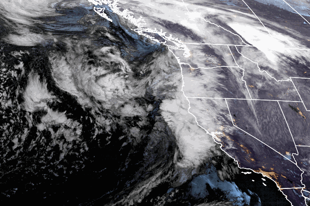
The next storm moves into northern California Friday afternoon, but light snow showers could break out ahead of the storm in the morning, with steadier snow showers moving in later in the day. Then a cold front with a period of heavier snow is possible Friday night, and snow showers lingering into Saturday morning before ending. Snow levels may initially start just above the base around 6500 ft, but falling during the evening below the base. 

Not much change to the forecast this morning. Here is the final snowfall forecast for this storm. We could now see 3-6 inches of snow at the base, 6-9 inches at mid-mountain, and 7-11 inches up top by Saturday morning when the snowfall ends. 

Strong winds Saturday morning drop off through the day with clearing skies through the afternoon. Highs only in the 20s on the upper mountain and 30s at the base.

Sunday Night Storm:

We should see a break in the action through most of Sunday with increasing clouds & colder temperatures. Highs in the 20s on the mountain and 30s at the base. South/southwest winds gusting up to 30 mph up top.

The next system moves in Sunday evening and lasts into Monday morning bringing the chance for light snow showers. This system is a closed low moving in to our south over central/southern CA with the heaviest snowfall staying to the south.

This storm is colder with all snow to the base and higher snow ratios with a more powdery snow up top. We could an additional 1-3 inches at the base, and 2-4 inches on the mountain by Monday morning. We begin to clear out Monday afternoon with a few scattered snow showers still possible. Cold with highs in the 20s on the mountain to around 30 degrees at the base.

Tuesday – Wednesday:

Expecting a drier pattern for Tue – Wed behind the Monday system. Mostly sunny skies Tuesday with highs in the 20s on the upper mountain, warming into the 30s at the base by Wednesday. Wednesday we could see increasing clouds ahead of the next storm approaching.

Long-Range:

The next storm could possibly move in for New Year’s Eve, but the long-range models are still in disagreement on whether this storm tracks into northern CA or stays just to the north of the Tahoe Basin. Stay tuned all week as we fine-tune the forecast for this system.

The pattern may remain active with additional storms moving through northern CA through the 1st week of January.

BA

lake tahoe weather snowfall forecast Squaw Weather Forecast
Bryan Allegretto
Bryan Allegretto

Share this article:

Recent Posts

  • Weather ·
  • March 29, 2023·

Partly Sunny Wed-Sun w/ Snow Showers Possible

Snowfall Reports: 12 inches of new snow fell on the mountain in the past 24 hours as of 5 AM…
Read more
  • Weather ·
  • March 28, 2023·

Snow & Strong Winds Tuesday

Tuesday  – Wednesday Storm: Snow showers are pushing in Tuesday morning, with heavier snow expected later in the morning into…
Read more
  • Weather ·
  • March 27, 2023·

Snowstorm Tuesday, Snow Showers Wed-Sun

Monday: Monday will start out sunny with highs in the 30s at the base and 20s up top. Some high…
Read more

Social

Instagram Twitter Facebook Youtube

Contact

   Email Us
   1.800.403.0206

Our Partners

U.S. Forest Service Logo
1960 Olympic Valley Road
Olympic Valley, CA 96146

©2022 Palisades Tahoe

Alterra Mountain Company
  • Privacy Policy
  • Terms of Service
  • Photo Upload Terms of Use
  • Accessibility
  • Do Not Sell My Personal Information
  • Privacy Policy
  • Terms of Service
  • Photo Upload Terms of Use
  • Accessibility
  • Do Not Sell My Personal Information