

Monday – Tuesday:
Mostly sunny skies with highs in the 40s to near 50 degrees at the base.
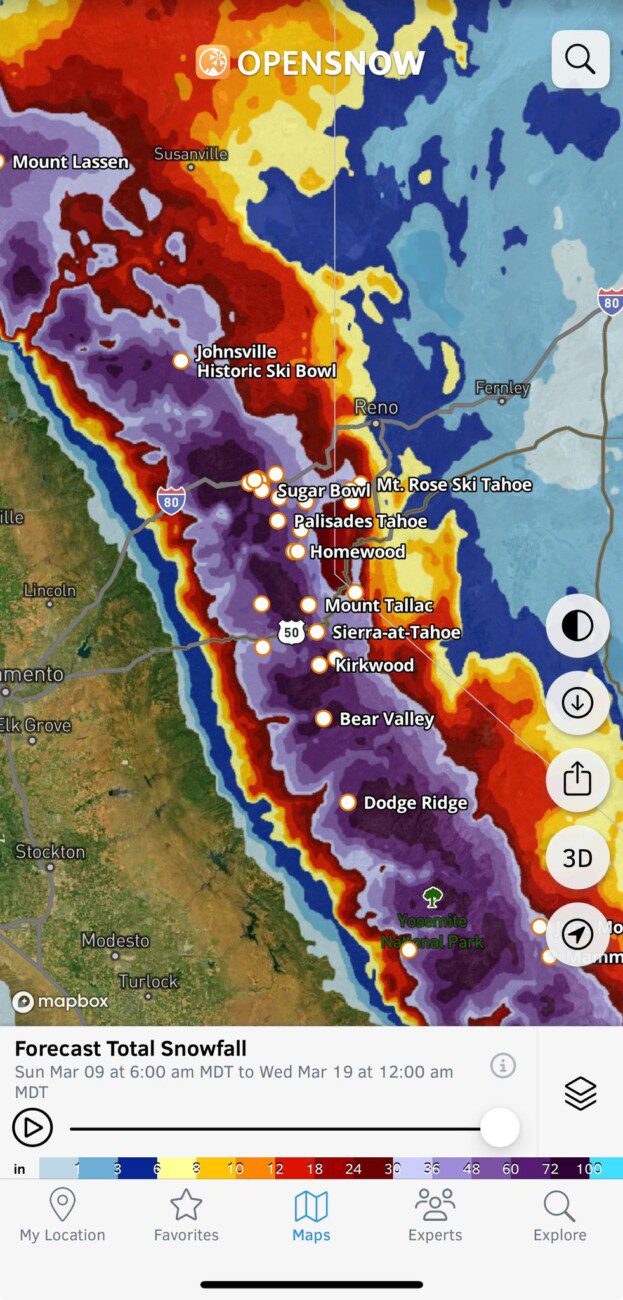
Wednesday – Thursday Storm:
The latest model runs now show snow showers reaching the mountain between midnight and 4 AM and spreading east across the Sierra into Wednesday morning. Highs in the 30s to near 40 degrees at the base. Ridgetop winds from the SSW increase through the day with gusts up to 80-100+ mph by evening, likely closing upper mountain lifts.
The cold front with the heaviest snowfall is expected to move through Wednesday night with snow levels plummeting well below the base. Scattered snow showers are expected on Thursday. Highs in the 30s for the lower elevations and 20s for the higher elevations. The winds drop off making for a good day to hit the fresh snow on the mountain.
The snow level forecasts look a bit warmer again for the daytime hours on Wednesday. They could start near the base early Wednesday morning before peaking out around 6500-7000 ft. midday Wednesday. Then falling as the heaviest precipitation with the front moves in and dropping below the base by evening and bottoming out around 2500-3000 ft. Wednesday night.
Snow levels stay below 5000 ft. on Thursday as we could pick up our final 3-6 inches of snow, but most of the snow is on the ground by Thursday morning. Storm totals by early Friday morning could be around 16-22 inches at the base, 22-28 inches near mid-mountain, and 26-33 inches up top.
Friday System:
A weaker system moves through Friday into Friday night bringing us more snow showers. It stays cold with snow levels likely staying below the base. The winds crank up again with ridgetop winds from the west gusting up to 50-70+ mph during the day, which could affect some upper mountain lifts. Highs in the 20s & 30s again.
With the snow levels staying low and snow ratios staying fairly high, that could be enough for an additional 2-6 inches of snow for the lower mountain and 3-7 inches up top.
Additional scattered snow showers are possible into the day on Saturday with very light accumulations expected right now. The winds drop down again with highs in the 30s.
Saturday night – Sunday Storm:
We are still tracking another fairly big storm for Saturday night into Sunday with snow showers into Sunday night. The winds crank up again for Sunday with ridgetop gusts from the SW up to 80-100+ mph. Another storm day with lift closures.
The snow should be pretty heavy most of the day with highs in the 30s for the lower elevations and 20s for the higher elevations, with snow levels staying below the base. We could see similar snowfall totals as the Wed – Thu storm, but without the rain at the beginning near the base.
Monday – Tuesday Snow Showers:
A final weaker system is still forecast to move through Monday with snow showers possibly lingering into next Tuesday the 18th. This system looks weak like the Friday system, so we are expecting inches not feet of additional snowfall.
Long-Range Forecast:
The long-range models continue to show high-pressure building in near the West Coast beyond the 18th into the last week of March. That is expected to shift the storm track to our north with a drier pattern after all of the storms over the next week.
A storm or two could brush us on the southern edge, so we’ll watch for that, but overall we should see a much quieter weather pattern.
The longer-range models suggest that the pattern could shift a little around the end of the month, possibly bringing some troughing near the West Coast opening the storm door.
That shift may be brief only lasting a few days, but it could be enough for another storm or two to track farther south into northern CA before the end of the month into the first few days of April. We’ll be keeping an eye on that.
BA
