

The weekend storm trended in the wrong (warmer) direction over the past 24 hours. Still a wet and windy weekend ahead, but most of the snow may stay above 8000-9000 ft. through Monday. A colder pair of storms are still on track for the Christmas holiday. Let’s get into the details.
Thursday:
We have a break on Thursday as the storm track has lifted back to our north, along with a lot of the clouds. Partly – mostly sunny skies with highs in the 40s to near 50 degrees down at the base.
Friday – Monday Storm:
We are still on track for an increase in clouds and winds on Friday with ridgetop gusts up to 80-100 mph, and rain moving in by the end of the day. Several of the models are back to a break in the precipitation on Saturday, with the winds coming down some, but we could still see some showers.
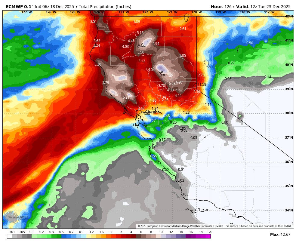
Saturday night into Monday, the AR (atmospheric river) of moisture pushes back into northern CA, aimed at the northern Sierra. The bad news is that some models are back to showing the AR lifting north on Monday instead of sagging south, while others keep the AR pointed at Tahoe through Monday before lifting north on Tuesday. That will affect snow levels and precipitation totals.
The one difference is the lower precipitation totals near the Tahoe basin if the AR stays pointed just to our north and lifts north on Monday, with totals of only up to 2.5 – 5.0 inches of precipitation by Monday morning. If the AR stays aimed at us through Monday, we could see up to 8-10 inches of mainly rain!
Staying on the south side of the AR is the warmest scenario with snow levels staying near to above 9000 ft. through Monday. Aimed right at us, the snow levels could dip as low as 8000-8500 ft. at times, mainly Friday night and again Sunday night into Monday. Without the sag a little to our south on Monday, the chance of snow below 8000 ft. looks to have disappeared for now.
The difference in the position of the AR among the model solutions is very small on a global scale, but can have BIG implications for snowfall amounts due to the snow levels and totals being different. As of this morning, I’m expecting up to several inches of wet snow above 8000 ft. by Monday night, but the snow accumulation line is questionable, and significant snowfall may stay above the top.
Tuesday:
Tuesday looks like a mainly dry day as the AR lifts north in response to the trough digging along the West Coast, and the next storm spinning up in the trough doesn’t look to move in until the 24th. But still a question mark of a day between storms.
Christmas Storms:
The trough is still expected to dig south by Tuesday and open the door for colder storms to spin up off the coast and draw in quite a bit of moisture from the south before moving into CA between the 24th – 26th.
The latest model runs continue to show two back-to-back systems spinning up into the trough and pushing into CA on Christmas Eve and Christmas Day, with the 2nd system possibly moving more slowly with snow into the 26th, and some models linger snow showers into the 27th.
These storms continue to look like they will have lots of moisture being drawn in with heavy snow expected for the northern and central Sierra mountains, including the Tahoe basin. Most of the models continue show snow levels to the base of the mountain starting Wednesday through the end of next week.
This is the Christmas Miracle storm that we have been talking about all week, and the possibility of for a while now. Over the next few days, I will start to dig into potential snowfall amounts by elevation. We are expecting strong ridgetop winds over the next week, with most days having gusts from the SW up to 80-100 mph, with the exception being Saturday.
Stay tuned for updates on these storms each day as we get closer. Once snow is falling on the mountain, it will mostly be on top of bare ground, so expect the mountain crews to take some time to pack it down and start opening trails, which could happen more slowly than you hope as the snow first starts to accumulate.
Long-Range Outlook:
The longer-range models continue to show a trend towards the trough lifting north by the 28th, with high pressure sneaking in. That would bring us a drier pattern from around the 28th and maybe through the end of the month.
Some models try to dig the trough back south a bit by the end of the month into the 1st week of January, but that may only be far enough south to brush us with lighter precipitation on the southern edge of storms. Overall, we could see a drier pattern if the current trend continues.
Let’s hope that the trough can dig farther south again and we can pick up more snow by the end of the month into January. I’ll continue to watch the trends, but we have a lot of weather to get through over the next week.
BA
