Skip to content
Palisades Tahoe Logo Palisades Tahoe Logo Palisades Tahoe Logo
Explore
Main Menu
  • Explore Palisades Tahoe
  • Base to Base Gondola
  • Our New Name
  • Explore Legendary Lifts
  • Palisades Tahoe Blog
  • About Lake Tahoe
  • About Us
Plan Your Visit
Main Menu
  • Tickets & Passes
  • Lodging
  • Lessons & Guides
  • Deals & Packages
  • Rentals & Demos
  • Travel Here
  • Getting Around
Mountain Information
Main Menu
  • Snow and Weather
  • Lift and Grooming Status
  • Webcams
  • Hours of Operation
  • Trail Maps
  • Parking & Road Conditions
  • Snowfall Tracker
Events & Activities
Main Menu
  • Events Calendar
  • Activities
  • Dining & Apres
  • Shopping
  • Things To Do In Lake Tahoe
  • Groups, Meetings & Weddings
  • Ski & Snowboard Teams
IKON PASS HOLDER LODGING DISCOUNT

Ikon Pass holders save up to 20% on slopeside lodging at The Village at Palisades Tahoe.

SLOPESIDE LODGING
Icon / FlashCreated with Sketch.
View All Offers
  • Weather

Rain/Snow Showers Possible Friday, Snow Friday Night into Saturday

  • Mar 3, 2022
  • 7:59 am

Thursday:

Partly sunny with some clouds Thursday with highs in the 40s on the mountain to near 50 degrees at the base. Ridgetop winds gusting from the south up to 40+ mph.

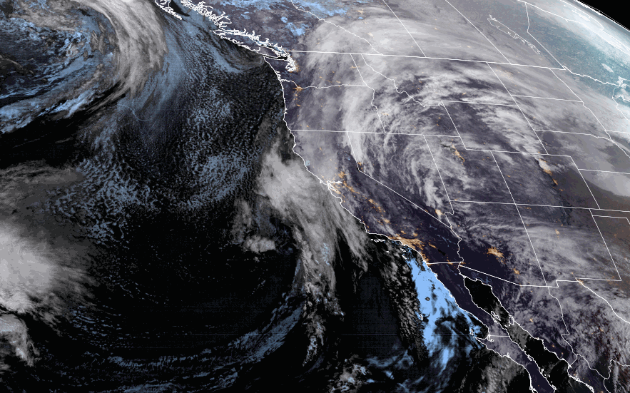
Thursday Night – Saturday Systems:

The next storm is digging south and splitting as it moves into CA Thursday. That is delaying the onset of the precipitation as the flow turns southerly and the 1st wave moves in to our south over southern CA. Rain and snow showers may hold off until Friday morning.

Snow levels start high around 7000-8000 ft. Friday morning and then falling to 6000-7000 Friday afternoon, that will bring them close to the base but they could not reach the base until evening. We may only see a coating to an inch of snow at best by Friday on the upper mountain. Highs drop into the 30s Friday with ridgetop winds gusting up to 60+ mph from the southwest by the end of the day.

The snow showers increase Friday night as a 2nd colder system dives into the region. This sets up a much better chance for snowfall accumulation and powdery vs wet snow as snow levels plummet. Snow showers continue into Saturday morning and become more scattered into the afternoon. Highs only in the 30s at the base and 20s up top. The winds should come down some as well but could gusting from the north-northwest up to 40+ mph up top.

We should clear out Saturday night. By Saturday morning we could see an additional 3-6 inches of snow on the mountain. Scattered snow showers Saturday could bring light additional accumulations of 1-3 inches during the day. Storm total of 3-6 inches at the base and 5-10 inches on the mountain possible by Saturday evening as the storm starts to clear the region.

Sunday – Tuesday:

A drier pattern returns Sunday into the first half of next week as high pressure builds back in over CA. It starts cold Sunday with highs in the 30s at the base and 20s up top. Mostly sunny skies continue through Tuesday with highs warming into the 40s at the base and 30s up top.

Long-Range:

The long-range models disagree on whether or not the trough over the West backs over CA again by midweek with additional systems dropping down from the north the 2nd half of next week. If not the drier pattern could continue. It looks like we may just see some colder air and stay dry through the end of next week.

The long-range forecast models also disagree on what happens by mid-month into the 3rd week of March. Some models keep high pressure over CA with the dry pattern continuing. Other models suggest a trough could form in the northeast Pacific off the West Coast by mid-month, which could allow storms to spin up off the coast and push in northern CA. We’ll continue to keep an eye on that as we get closer.

BA

lake tahoe weather palisades tahoe weather forecast snowfall forecast
Bryan Allegretto
Bryan Allegretto

Share this article:

Recent Posts

  • Weather ·
  • March 21, 2023·

Weak Systems & Snow Showers thru Sunday

Tuesday Storm: The next storm pushes snow showers back in by later Tuesday morning, with steadier snow through Tuesday afternoon.…
Read more
  • Weather ·
  • March 20, 2023·

More Weak Systems Tuesday-Friday

Snowfall Reports: No real surprises with the weak storm that moved through on Sunday. We were expecting 3-11 inches from…
Read more
  • Weather ·
  • March 19, 2023·

Two More Storms Sun & Tue

Sunday Storm: Snow showers are moving in Sunday morning, and will continue through the day before becoming more scattered Sunday…
Read more

Social

Instagram Twitter Facebook Youtube

Contact

   Email Us
   1.800.403.0206

Our Partners

U.S. Forest Service Logo
1960 Olympic Valley Road
Olympic Valley, CA 96146

©2022 Palisades Tahoe

Alterra Mountain Company
  • Privacy Policy
  • Terms of Service
  • Photo Upload Terms of Use
  • Accessibility
  • Do Not Sell My Personal Information
  • Privacy Policy
  • Terms of Service
  • Photo Upload Terms of Use
  • Accessibility
  • Do Not Sell My Personal Information