

Monday Wind & Snow:
It will be a windy day with ridgetop winds gusting from the southwest up to 70-90+ mph, likely closing some upper mountain lifts. Snow levels look to hover near the base with rain possibly mixing in near the base and low snow ratios on the lower side on the mountain.
With the lower snow ratios and light precipitation amounts, we are not expecting much snow for the mountain. We could see 1-3 inches on the lower mountain and 2-5 inches on the upper mountain.
Tuesday – Friday:
High pressure will build in over the region bringing nice weather for the rest of the week through Friday. Mostly sunny skies are expected each day with highs into the 40s. Maybe hitting 50 degrees down near the base by Wednesday – Thursday.
Saturday Wind & Rain:
Expect a windy day on Saturday with ridgetop winds gusting up to 80-100+ mph. That would bring another Saturday with upper mountain lift closures. Rain showers could move in by the afternoon and clear out Saturday night as this is another fast-moving system.
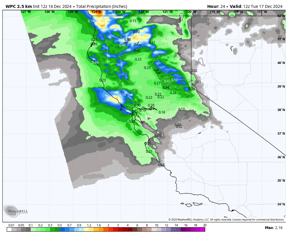
We will keep an eye on this storm all week to see how far the steadiest precipitation will push. This morning we have some forecast models showing no precipitation reaching this far south, while the others show up to 1 inch of precipitation falling. That’s a big difference.
Snow levels could start above 9000 ft. this time and may only bottom out around 7000-7500 ft. before rising again Saturday night as the storm clears. That means rain near the base and this time up to the upper mountain possibly at the start.
The rain mixing in and low snow ratios where it is snowing will limit snowfall with any snow falling being on the wetter side. We could see 1-3 inches of wet snow on the upper mountain. We’ll continue to fine-tune the forecast all week.
Sunday – Monday:
Looking at Sunday into next Monday the models are split on how far south the storm track will be. Some models have been trending farther south and have more mild systems catching us on the southern edge with quite a bit of preciptiation falling over the 2-day period. Other models keep the storm track just to our north and are completely dry over the 2-day period.
This pattern with the ridge over the West and teh trough in the northeast Pacific has been and will continue to be a pain to forecast until storms get closer as we don’t know how far south the storms will be able to push as they battle the ridge to the east. We’ll continue to watch the trends.
Christmas Eve Storm:
The latest forecast model runs continue to show the western ridge shifting east a bit with a weak trough digging into northern CA on Christmas Eve. That could bring in a fast-moving but colder storm that could bring us a quick shot of snow for Christmas Eve.
Long-Range Forecast:
By next weekend we are transitioning into a positive EPO (eastern Pacific Oscillation) pattern which features troughing over Alaska into the northeast Pacific, and eventually, a flatter and stronger jet stream underneath that extends towards the West Coast. That pattern could start to establish itself better for a few days after Christmas.
Similar to next weekend we could catch the southern edge of milder storms hitting the Pacific NW, but maybe a better chance for them to push a bit farther south into the northern Sierra. This is a pattern that can bring us some precipitation if the storms track far enough south, but we will likely deal with some snow level issues.
We’ll continue to watch the trends as we get closer…
BA
