

We will have a nice weekend with partly-mostly sunny skies and milder weather lasting into the beginning of next week. Highs into the 60s for the lower elevations and 50s for the upper mountain.
Thursday – Friday Storm:
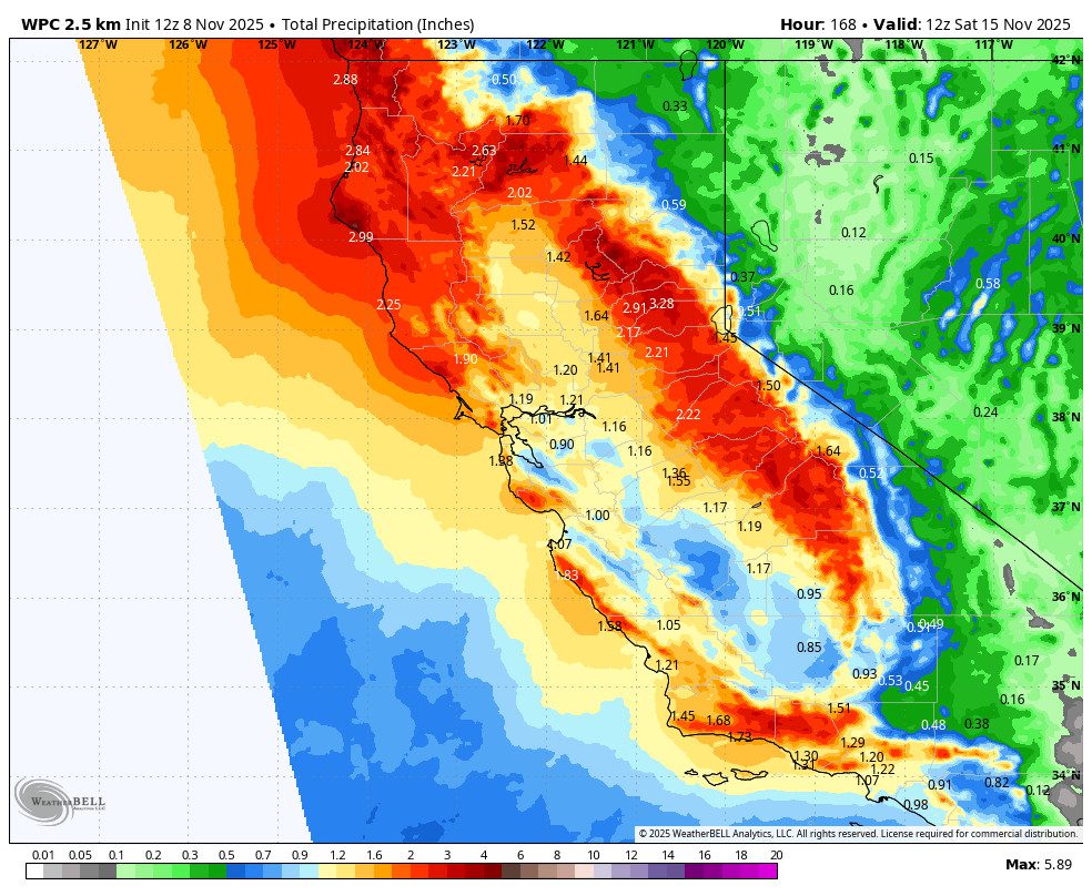
We continue to track a pattern change that will start by bringing us a wet storm from Thursday into Friday. The forecast models have been all over the place with precipitation amounts and snow levels the last few days. The latest model runs show a warm and wet storm for Thursday as it does tap into warmer subtropical moisture before pushing into CA. Then slightly colder air moves in on Friday.
The latest model runs are showing up to 2+ inches of total precipitation falling by Friday night. The snow levels could start out above 9000 ft. and only fall as low as 8000 ft. on Thursday, and then colder air later Thursday night into Friday could drop them lower. Some models show snow levels staying above 8000 ft, while others dip below 6000 ft. This has to be ironed out over the next several days as we get closer.
With up to 2+ inches of precipitation possible, the snow levels will be critical to snowfall accumulations on the mountain. We will have to continue to look at the details of this storm as it approaches. I’ll continue to adjust the forecast for snow levels and potential snowfall. As of right now, the best chance for several inches looks to be on the upper mountain, and mostly later Thursday night into Friday.
Behind the Storm:
We should be shifting into a colder pattern behind the storm. The latest model runs continue to show the trough sticking around through mid-month and into the 3rd week of November. Which could leave the door open to a weaker but colder storm around the 17th.
The temperatures will be colder by next weekend behind the storm. Temperatures around 7500 ft. near mid-mountain are forecast to be 30s after the storm through the 3rd week of November. 40s near the base. But colder at night, and we should see better weather for some snowmaking at night.
Long-Range Forecast:
The longer-range ensemble mean models are trending towards high pressure building in the eastern Pacific off the West Coast as we get closer to the 20th. That could bump the storm track farther north and keep us drier beyond the 17th. That is what the models are now suggesting between the 18th and 23rd.
If the high-pressure ridge stays off the coast, then we could still see a northern flow and below-average temperatures continuing, which is also what they are currently suggesting. That is not a good pattern for big storms behind the wet storm this week, but a chance for snow around the 17th if the storm track doesn’t stay north, and a better pattern for making snow.
BA
