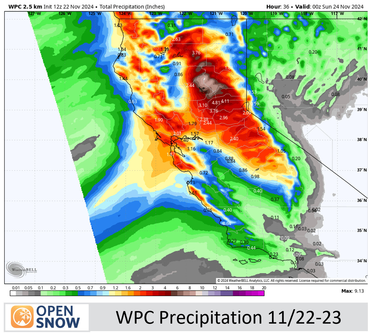
Friday – Saturday Rain & Snow:
Rain & high elevation snow returns to the mountain Friday morning. It will be mild to start on Friday with highs topping out in the 40s for the lower elevations and 30s for the higher elevations. Ridgetop winds continue to gust up to 70-90+ mph. Snow levels will start out up near 9000 ft. before falling near 7000-7500 ft. by evening.
Then the heaviest precipitation is expected to fall Friday night with the front moving through. The cold air behind this front is not that cold, and snow levels may only fall to around 6200-6700 ft. (near to just above the base) by early Saturday morning.
Then snow showers for Saturday with gusty winds up to 70-80+ mph for exposed ridges. Highs only in the 30s for the lower elevations and 20s for the higher elevations. The snow levels dip to around 5500-6000 ft. The snow showers are expected to taper off by Saturday night.
Above 8000 ft. we expect mostly all snow by later Friday into Saturday. Near the base is the opposite where we could see mostly rain until Saturday morning. My forecast assumes that, but my forecast could be too low if the snow levels drop faster than forecast. We could see totals of around 2-6 inches at the base, 17-23 inches near mid-mountain, and 23-29 inches up top by Saturday night.
Sunday – Tuesday Weather:
The trend on the latest model runs early Friday morning is for a lull on Sunday with partly sunny skies, and maybe only scattered snow showers at best for Sunday night into Monday. It will be colder with highs in the 30s for the 3 days. The winds should be lighter Sunday into Monday but Tuesday we could see a final round of stronger winds with ridgetop gusts up to 60-80+ mph.
The best chance for some steadier snow could be Monday night into Tuesday. Some forecasts show steadier precipitation on Monday as well, so we’ll continue to watch the trends.
The snow levels may start low Sunday night but rise up near the base by Monday afternoon, and possibly up to around 6300-6800 ft. Tuesday morning as some milder air flows in ahead of the final wave before snow levels fall again by the end Tuesday night. That means there is a chance for a little rain to mix in for the lower elevations near the base.
In total for the 48-hour period for Sunday night through Tuesday, we could see an additional 6-11 inches of snow near the base, 11-16 inches near mid-mountain, and 14-20 inches up top. We have two more days to fine-tune the forecast.
Thanksgiving Holiday Weather:
The latest trend on the models is still for high pressure to build in off of the Pacific NW coast during the 2nd half of next week through the Thanksgiving holiday. That will make it harder for any storms to sneak underneath into CA.
A few model runs show a little moisture trying to sneak in for Thanksgiving Day, but most have the low off the coast under the ridge falling apart by the time it reaches the CA coast. So for now, we are expecting drier weather for Wednesday through Thanksgiving weekend. It may stay on the cooler side with mostly sunny days and highs only in the 30s.
Long-Range Forecast:
The long-range models continue to show a high-pressure ridge strengthening over the West Coast during the 1st week of December. That should block the storms and keep them well to our north through the period, but we’ll continue to watch the trends.
It will likely get a little milder as well. Highs could reach into the 40s as early as Thanksgiving weekend into the following week for the lower elevations if the current pattern forecasts hold.
BA


