Skip to content
Palisades Tahoe Logo Palisades Tahoe Logo Palisades Tahoe Logo
Explore
Main Menu
  • Explore Palisades Tahoe
  • Base to Base Gondola
  • Our New Name
  • Explore Legendary Lifts
  • Palisades Tahoe Blog
  • About Lake Tahoe
  • About Us
Plan Your Visit
Main Menu
  • Tickets & Passes
  • Lodging
  • Lessons & Guides
  • Deals & Packages
  • Rentals & Demos
  • Travel Here
  • Getting Around
Mountain Information
Main Menu
  • Snow and Weather
  • Lift and Grooming Status
  • Webcams
  • Hours of Operation
  • Trail Maps
  • Parking & Road Conditions
  • Snowfall Tracker
Events & Activities
Main Menu
  • Events Calendar
  • Activities
  • Dining & Apres
  • Shopping
  • Things To Do In Lake Tahoe
  • Groups, Meetings & Weddings
  • Ski & Snowboard Teams
IKON PASS HOLDER LODGING DISCOUNT

Ikon Pass holders save up to 20% on slopeside lodging at The Village at Palisades Tahoe.

SLOPESIDE LODGING
Icon / FlashCreated with Sketch.
View All Offers
  • Weather

Nice Weekend, Winter Returns Tuesday

  • Feb 16, 2023
  • 8:12 am

Thursday – Friday:

We have mostly sunny skies Thursday morning with some high clouds. We could see some clouds around through Friday with partly sunny skies as the trough off the coast splits and the cut-off low forms and drops south off the coast. Highs into the 30s for both days. The winds look to be on the lighter side with some ridgetop gusts from the southwest up to 30+ mph Thursday.

The Holiday Weekend:

Saturday through Monday we will have really nice weather for the 3-day President’s Weekend as a strong high-pressure ridge is set up near the West Coast. We should see mostly sunny skies all 3 days with highs into the 40s for the lower elevations and 30s for the higher elevations.

Tuesday – Wednesday Cold Front:

By Tuesday the cold trough is digging south towards our region. We may start the day with partly-mostly sunny skies and hit 40 degrees for a high at the base. But then we could see increasing clouds and winds through the afternoon as the cold front approaches. We could see some upper mountain lift closures by the end of the day from strong winds.

Some of the latest model runs show snow arriving as early as late afternoon Tuesday and the rest show snow moving in Tuesday evening. We will likely see a round of heavier snow with the cold front Tuesday night. The cold trough is established over the region by Wednesday with snow showers likely continuing and highs only in the 20s.
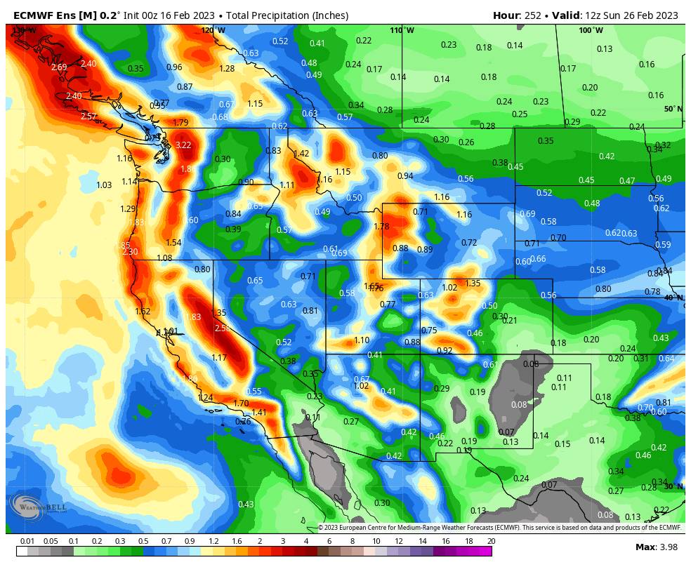
Long-Range:

Behind the front Tuesday night into Wednesday, the latest model runs continue to agree that a slow-moving low-pressure center drops down the West Coast through Saturday the 26th. That could continue to stream moisture into the cold air over the Sierra from Tuesday night through Saturday the 26th. The models aren’t showing only deep moisture feeds off of the Pacific or any atmospheric rivers. Just steady light-moderate snowfall over a prolonged period.

That could drop 6-12+ inches of snow on the mountain each day over the 4-days. Not 2-4 feet in a day, but over 4 days if the latest forecast for 2-3 inches of total precipitation doesn’t change. It’s still very early to forecast any snowfall. We’ll be within 5-7 days of the storm by Saturday, and that’s when I’ll start to calculate the detailed snowfall forecasts for the storm.

We could see several more storms move through from Monday the 27th through at least March 3rd if the trough remains over the West Coast. There are some signs that the trough could start to lift out of the region beyond the 3rd, but we could see quite a bit of new snow by then. 

BA

lake tahoe weather palisades tahoe weather forecast snowfall forecast
Bryan Allegretto
Bryan Allegretto

Share this article:

Recent Posts

  • Weather ·
  • March 24, 2023·

Drier w/ Spotty Snow Showers thru Sunday

Snowfall Report: 3-5 inches of new snow fell on the mountain, from the base to the upper mountain, in the…
Read more
  • Weather ·
  • March 23, 2023·

Snow Thursday, Drier for the Weekend

Snowfall Report: An additional 2 inches of snow fell on the mountain in the past 24 hours as of 5…
Read more
  • Weather ·
  • March 22, 2023·

Scattered Snow Showers Continue

Snowfall Report: We were expecting 1-4 inches to fall Tuesday-Tuesday night. We picked up the lower end of the forecast…
Read more

Social

Instagram Twitter Facebook Youtube

Contact

   Email Us
   1.800.403.0206

Our Partners

U.S. Forest Service Logo
1960 Olympic Valley Road
Olympic Valley, CA 96146

©2022 Palisades Tahoe

Alterra Mountain Company
  • Privacy Policy
  • Terms of Service
  • Photo Upload Terms of Use
  • Accessibility
  • Do Not Sell My Personal Information
  • Privacy Policy
  • Terms of Service
  • Photo Upload Terms of Use
  • Accessibility
  • Do Not Sell My Personal Information