

Monday – Wednesday:
We have colder air behind the front on Monday. We saw overnight lows finally drop into the 20s for all elevations Sunday night bringing us much better snowmaking conditions. Highs on Monday will only warm into the 30s down the lower elevations near the base.
Mostly sunny skies are expected through Wednesday, with maybe a few increasing clouds during the day on Wednesday ahead of the next storm. Highs will warm into the 40s on Tuesday and Wednesday. Ridgetop winds will increase from the southwest Wednesday, gusting up to 60-70+ mph by the end of the day, which could affect some upper mountain lift operations.
Wednesday Night – Thursday Storm:
24 hours ago and back, the forecast models all showed the next system approaching the West Coast weakening significantly and staying well to our north. Over the past 24 hours, the models have all been trending toward the storm holding together better and pulling in more moisture, as well as digging farther south into northern CA as it moves through Wednesday night into Thursday.
This is a weak and fast-moving system with snow showers only expected from the early morning hours before sunrise on Thursday through Thursday afternoon, and clearing by the end of the day on most model runs. Highs drop into the 30s with snow levels dropping below lake level pretty quickly at the start. The winds drop through the day on Thursday.
Snow levels look to dip near 5000-5500 ft. pretty quickly over the Tahoe Basin at the start, and then could hover around 4500-5500 ft. through Thursday. We could see around 2-5 inches at the base, 3-6 inches near mid-mountain, and 3-7 inches up top by Thursday night.
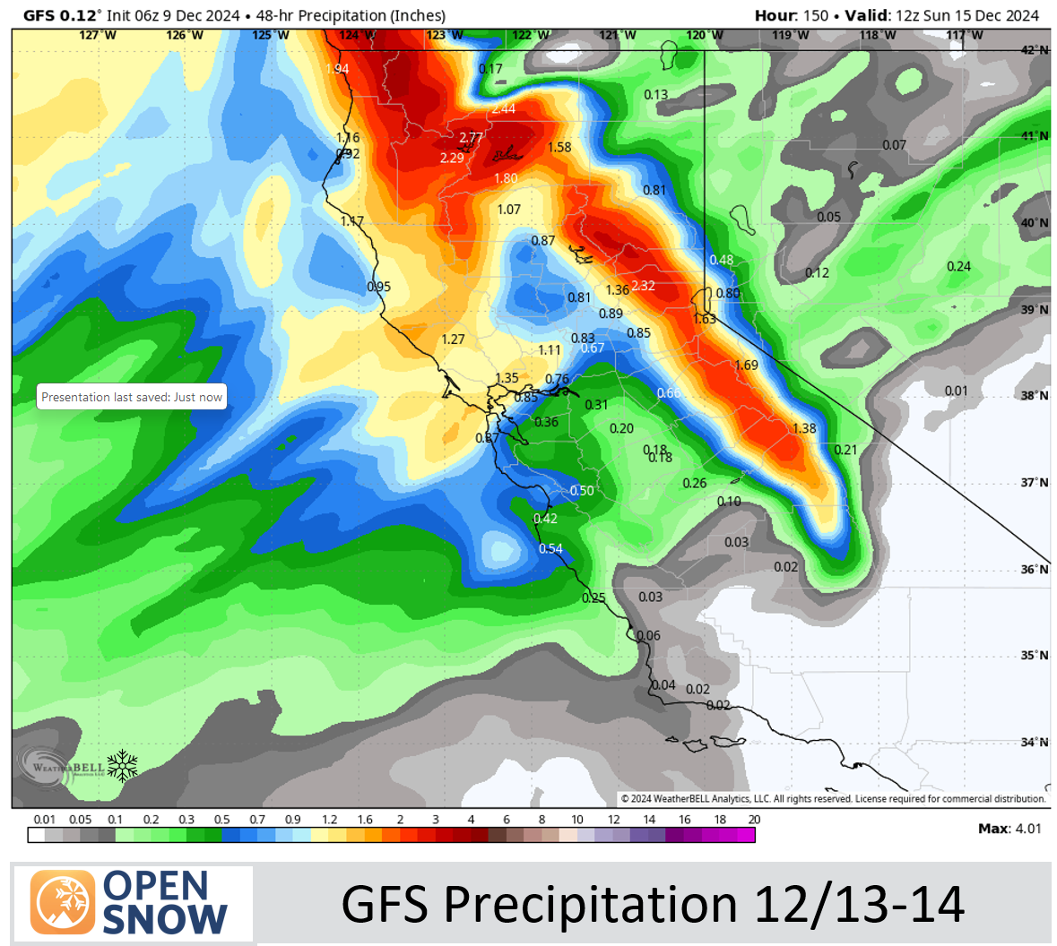
Friday Night – Saturday Night Storm:
This storm we have been tracking but we had half of the forecast models almost completely dry 24 hours ago, and the trend was toward a drier scenario over the last two days. That flipped as well over the past 24 hours with a wetter trend, and precipitation of varying amounts on all models this morning (Monday).
The latest model runs show a break between storms Thursday night through most of the day on Friday. Highs into the 30s for the upper mountain and 40s near the base. The rain and snow could reach the mountain around the end of the day into the evening, with the heaviest precipitation expected later Friday night into Saturday. Snow showers Saturday night taper off by Sunday morning.
Snow levels could be an issue Friday night before the cold front moves through. Initially, we could see a dip as precipitation falls into drier air with evaporational cooling dropping snow levels near the base Friday evening. But the models show them rising up to around 7000-7500 ft. after that initial dip before slowly lowering to around 6500-7000 ft. by Saturday morning.
That means could see some rain Friday night near the base. Then colder air moves in on Saturday with highs only in the 30s for the lower elevations and snow levels falling below the base by midday. By early Sunday morning, we could see snowfall totals of around 5-9 inches at the base, 10-15 inches near mid-mountain, and 13-18 inches up top.
We are expecting strong winds on Saturday with gusts up to 70-90+ mph over the ridges, which could close some of the upper mountain lifts during the storm.
Sunday Weather:
The storm clears and the winds drop during the day on Sunday. We should see partly-mostly sunny skies with highs in the 30s. It could be a fun day after a good dump of snow.
Monday Storm:
We are still watching for a final weak system to sweep through northern CA on Monday the 16th. This storm looks to be the weakest of the 3 with maybe a dusting up to a couple of inches of new snow if the current forecasts hold.
Drier Pattern:
The long-range models continue to show a drier pattern starting on the 17th through at least the 20th, but they also still show a large trough in the eastern Pacific nudging closer to the West Coast by the 21st. Right now the models don’t show any storms for the 17th – 20th.
Possible Active Pattern:
As the trough nudges closer to the West Coast it could push storms into the back side of the ridge over the West enough that we see wetter storms for the Pacific NW and possibly into northern CA. We will be on the edge of a possible wet pattern beyond the 20th if the forecasts hold, but the storms spinning up over the Pacific will be pretty strong. It could be a boom/bust scenario.
We’ll be watching the trends closely as we get closer…
BA
