Weekend Storm:
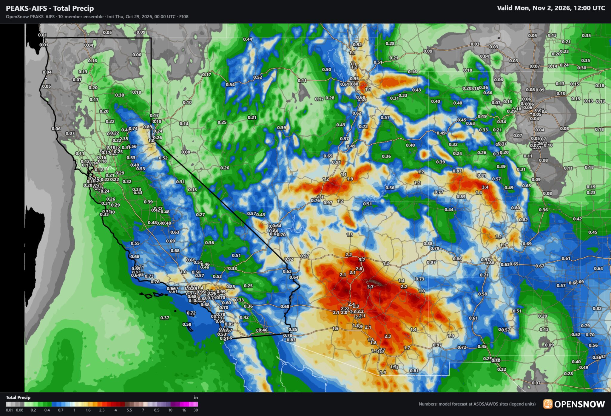
Looking at the current satellite imagery, we can see an area of low pressure near the Pacific Northwest coast, and moisture streaming towards the southwest coast. That area of low pressure will slowly drop south as the moisture pushes into the southwest and southern CA from Friday into Saturday. The low will help to try and draw the moisture far enough north to reach the northern Sierra.
The forecast models disagree on how much, with some only showing high-end totals over the mountain only up to 3-tenths of an inch, while others show up to 2 inches. Using my own formulas, I’m coming up with around 1 inch of total precipitation possible.
The snow levels will be tricky, as there is not much cold air available, but this is also not a super warm storm. Snow levels could fluctuate near 7000 ft. for most of the storm, higher during lighter precipitation and lower during heavier precipitation periods. They could rise up to 8000 ft. by Saturday during lighter showers, and then they could drop near the base by the end Sunday morning.
That means we expect mainly rain near the base, a messy mix for mid-mountain elevations, and several inches of snow possible on the mountain above ~7500 ft. By Sunday we could see totals up top of around 6-12 inches, with the lower end near 7500 ft. and waning the lower you go.
We will be able to use OpenSnow’s technology to estimate snowfall totals around the mountain, which are usually pretty close to the human-measured totals during the ski season.
The Start of November:
We should see the storm clear out by sometime on Sunday, with the sun returning and highs warming back into the 40s for the upper elevations and 50s for the lower elevations near lake level, as we head into next week.
Some of the latest long-range model forecasts show the chance for a weak system to try and push through the region later next week, but most are showing strong high pressure over the northern Rockies and high pressure over most of the West. So even though a large trough is pushing towards the West Coast, we may stay dry through the weekend of the 7th-8th.
Long-Range Outlook:
Beyond the 8th, the long-range models show the trough eventually pushing into the West Coast around the 10th and beyond. IF that happens, it should open the door to some wetter storms. There is fairly good agreement among the long-range models currently that a wetter pattern could develop before mid-November.
Let’s hope, because the snowmaking beyond this weekend could be marginal, with overnight lows not very cold for most elevations. Hopefully we will get some bigger snowstorms to help before Thanksgiving.
BA