Skip to content
Palisades Tahoe Logo Palisades Tahoe Logo Palisades Tahoe Logo
Explore
Main Menu
  • Explore Palisades Tahoe
  • Base to Base Gondola
  • Our New Name
  • Explore Legendary Lifts
  • Palisades Tahoe Blog
  • About Lake Tahoe
  • About Us
Plan Your Visit
Main Menu
  • Tickets & Passes
  • Lodging
  • Lessons & Guides
  • Deals & Packages
  • Rentals & Demos
  • Travel Here
  • Getting Around
Mountain Information
Main Menu
  • Snow and Weather
  • Lift and Grooming Status
  • Webcams
  • Hours of Operation
  • Trail Maps
  • Parking & Road Conditions
  • Snowfall Tracker
Events & Activities
Main Menu
  • Events Calendar
  • Activities
  • Dining & Apres
  • Shopping
  • Things To Do In Lake Tahoe
  • Groups, Meetings & Weddings
  • Ski & Snowboard Teams
IKON PASS HOLDER LODGING DISCOUNT

Ikon Pass holders save up to 20% on slopeside lodging at The Village at Palisades Tahoe.

SLOPESIDE LODGING
Icon / FlashCreated with Sketch.
View All Offers
  • Weather

Fresh Snow & Sunny Skies

  • Dec 31, 2020
  • 8:28 am

Snowfall Report:

We picked up 3 inches at the base and 5 inches up top from the quick-moving system that moved through Thursday night. That was exactly the amount we were expecting. That brings the season total to 85 inches on the upper mountain.

Thursday – Friday:

Mostly sunny for Thursday with highs in the 30s at the base and 20s up top. Winds coming down some during the day on Thursday but increasing from the north/northeast up to 40+ mph during the afternoon. Friday we should start the day with mostly sunny skies and then high clouds could start streaming in later in the day. Highs in the 30s on the mountain with lighter winds expected.

Weekend Showers:

The next storm takes aim at the Pacific NW on Saturday. We may be on the southern edge of moisture streaming into off the Pacific all weekend. We should see clouds with the chance for very light and scattered showers through the weekend. Snow levels could rise to 6500-7000 ft. by Saturday afternoon with rain showers at the base through Sunday.

For snowfall, we could see a coating of snow on the upper mountain every 12-hours or so. In total through Sunday night, we may only see 1-2 inches of snow up top. Ridgetop winds could be gusting from the southwest up to 40-50+ mph all weekend.
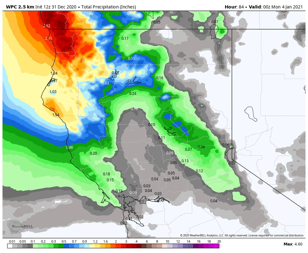
Monday Storm:

The next storm moves in Monday morning with some heavier snow during the day, and showers lingering into Monday night before ending by Tuesday morning. We may see snow levels start out above the base Monday around 6500-7000 ft. Then dropping to the base by evening. Ridgetop winds could be gusting to 70+ mph and could close down some upper mountain lifts.

Snowfall amounts for the upper mountain look to be in the 12-18 inch range through Monday night. Rain turning to snow at the base and 7-11 inches possible down to the base by Tuesday morning.

Long-Range:

We should see a break for Tuesday with mostly sunny skies and highs in the 30s with lighter winds.

The next storm could move in Wednesday into Wednesday night. This storm could drop similar amounts of snow as the Monday storm. We will have to watch the track as we get closer to be sure it doesn’t shift to our north and bring lesser amounts of snow.

We may have another break Thursday before another system is possible for next Friday.

There are signs of a drier pattern setting up starting the weekend of the 9th.

BA

lake tahoe weather snowfall forecast Squaw Weather Forecast
Bryan Allegretto
Bryan Allegretto

Share this article:

Recent Posts

  • Weather ·
  • March 21, 2023·

Weak Systems & Snow Showers thru Sunday

Tuesday Storm: The next storm pushes snow showers back in by later Tuesday morning, with steadier snow through Tuesday afternoon.…
Read more
  • Weather ·
  • March 20, 2023·

More Weak Systems Tuesday-Friday

Snowfall Reports: No real surprises with the weak storm that moved through on Sunday. We were expecting 3-11 inches from…
Read more
  • Weather ·
  • March 19, 2023·

Two More Storms Sun & Tue

Sunday Storm: Snow showers are moving in Sunday morning, and will continue through the day before becoming more scattered Sunday…
Read more

Social

Instagram Twitter Facebook Youtube

Contact

   Email Us
   1.800.403.0206

Our Partners

U.S. Forest Service Logo
1960 Olympic Valley Road
Olympic Valley, CA 96146

©2022 Palisades Tahoe

Alterra Mountain Company
  • Privacy Policy
  • Terms of Service
  • Photo Upload Terms of Use
  • Accessibility
  • Do Not Sell My Personal Information
  • Privacy Policy
  • Terms of Service
  • Photo Upload Terms of Use
  • Accessibility
  • Do Not Sell My Personal Information