Skip to content
palisades tahoe
Explore
Main Menu
  • Explore Palisades Tahoe
  • Discover Palisades Tahoe
  • Our Name Change
  • Explore Legendary Lifts
  • Palisades Tahoe Blog
  • About Lake Tahoe
  • Mountain Safety
Plan Your Visit
Main Menu
  • Lodging
  • Tickets & Passes
  • Lessons & Guides
  • Deals & Packages
  • Rentals & Demos
  • Travel Here
  • Ikon Pass Benefits
Mountain Information
Main Menu
  • Weather
  • Lift Status
  • Webcams
  • Hours of Operation
  • Trail Maps
  • Parking & Road Conditions
  • Snowfall Tracker
Events & Activities
Main Menu
  • Aerial Tram
  • Events Calendar
  • Activities
  • Dining & Apres
  • Shopping
  • Groups, Meetings & Weddings
  • Ski & Snowboard Teams
Summer High Camp Tram with wildflowers.
Basecamp for Lake Tahoe
Palisades Tahoe is the beating heart of Lake Tahoe adventure. Plan your trip with us today.
PLAN YOUR VISIT
Icon / FlashCreated with Sketch.
View All Offers

Fresh Snow, Cold Temps, & More Storms

  • By Bryan Allegretto
  • Weather
  • Nov 10, 2020

We picked up 5-9 inches of fresh snow from the storm over the weekend. That storm also brought in plenty of cold air for snowmaking to add to the natural snow.

We have mostly sunny skies through Wednesday with highs in the 30s on the mountain. Overnight lows in the teens & 20s will be cold enough for snowmaking to continue at night.

Thursday Night – Friday Storm:

A weak system will move through Thursday night into Friday night. Right now the precipitation amounts look pretty meager. Snow levels will be below the base Thursday night and then rising just above the base Friday.

We could see a dusting to an inch of snow at the base, and 1-2 inches of new snow on the mountain through Friday morning. Highs remaining in the 30s. Ridgetop winds increasing with gusts to 80+ mph by Friday evening.

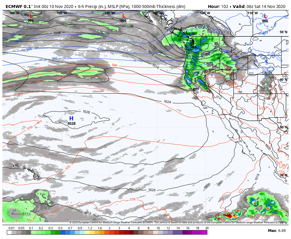
Friday Night – Saturday Storm:

Friday night into Saturday a stronger storm is possible. This system could bring moderal to heavy rain/snow. Snow levels may rise to around 7000 ft. Friday night into Saturday. Ridgetop winds gusting to 80+ mph Saturday morning and then lower later in the day.

We could see just rain at the base with this storm. from mid-mountain to the top we could see 6-12 inches of new snow by Saturday afternoon. A nice thick base-building snow. We should begin to clear out Saturday afternoon.

Long-Range:

We may see a break in the storms Sunday through next Tuesday. The long-range forecast models show another storm possibly moving into northern CA as early as later Tuesday into next Wednesday.

They also show another storm by the end of next week. The pattern we are in for the next 2 weeks should keep an active pattern going for northern CA with no long stretches of dry weather expected. More details as we get close to each storm.

BA

Share this article
Picture of Bryan Allegretto
Bryan Allegretto

Recent Posts

  • Weather ·
  • April 30, 2025·

Weekend Snow Showers Possible

There is a chance for high elevation snow showers for the first weekend of May. The mountain is aiming to…
Read more
  • Weather ·
  • April 28, 2025·

11 Inch Weekend Snowfall Total!

Snowfall Report: The weekend storm brought snow down to the base as we expected. We saw several inches accumulate on…
Read more
  • Weather ·
  • April 24, 2025·

Winter’s Quick Return

All of the focus this week is on winter’s last gasps over the weekend, as snow showers and low snow…
Read more

Social

Instagram Twitter Facebook Youtube

Contact

   Email Us
   1.800.403.0206

Our Partners

U.S. Forest Service Logo
1960 Olympic Valley Road
Olympic Valley, CA 96146

©2025 Palisades Tahoe

Alterra Mountain Company
  • Privacy Policy
  • Terms of Service
  • Photo Upload Terms of Use
  • Accessibility
  • Do Not Sell My Personal Information
  • Privacy Policy
  • Terms of Service
  • Photo Upload Terms of Use
  • Accessibility
  • Do Not Sell My Personal Information