

Snowfall Report:
The snow levels dropped lower than expected on Monday, bringing a coating of snow all the way to the base briefly as we saw cooling in an isothermal air column under the band of heavy precipitation, thanks to calmer winds as well. Snow accumulated fast on the upper mountain for a few hours and then settled overnight as the warmer air moved in.
The upper mountain picked up an additional 8 inches of snow on Monday, bringing the 3-day storm totals to 12 inches, which is the total we expected for this storm (7-14 inches). That brings the season total so far to just over 3 feet of snow at 8k’.
Tuesday Weather:
We have clouds around, and some sun is possible as well. Highs into the 40s. Ridgetop winds gusting up to 60-80+ mph from the SSW. The winds will stay this gusty over the ridges through Thursday before dropping through the day on Friday. The latest model runs are holding off on most precipitation from reaching us until after midnight.
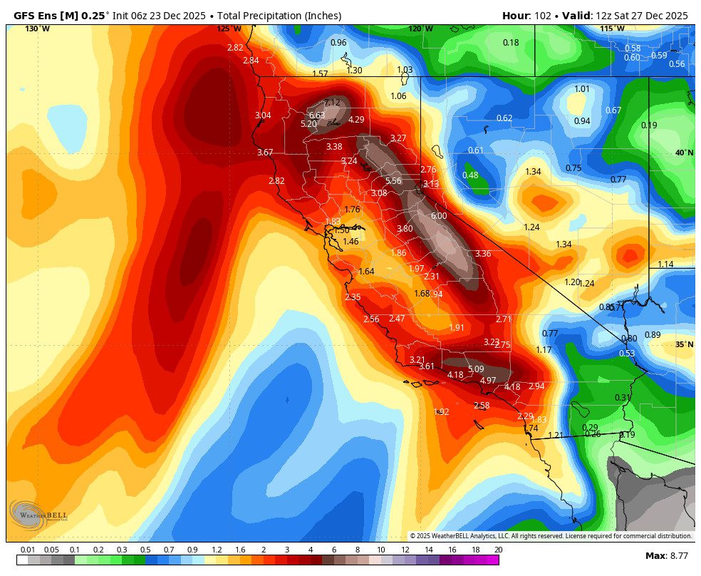
Wednesday – Friday Storms:
The latest model runs show the precipitation streaming north on the east side of the low along the coast, pushing into the northern Sierra during the early morning hours on Wednesday before sunrise, and then heavier precipitation into the day on Wednesday.
After that band of heavier precipitation from a south to north-oriented AR pushes through Wednesday morning, we could see the precipitation rates decrease later in the day on Wednesday into Wednesday night. Then increasing again on Thursday as the next storm pushes inland, with the heaviest snow of the storm, and then snow showers into Friday before ending Friday night.
The snow levels start high Tuesday night but are expected to fall pretty quickly as the heavier precipitation pushes in, helping to drag them down. We could start around 7500-8000 ft. after midnight, but then fall to 6500-7000 ft. by sunrise and to the base by late morning on Wednesday. That means we start with rain at the base but should turn to snow by midday or earlier.
Then, as the precipitation rates lighten Wednesday night, we could see them rise to around 6000-6500 ft., which is near to just above base with a little rain possibly mixing in under lighter showers. Then on Thursday, the colder storm drops them below the base again, and near to below 5000 ft. Thursday night into Friday.
I have the average snow:liquid ratios at 8k’ near 12:1, which could be a bit conservative, as they start closer to 9:1 and rise as high as 15:1 with some powdery snow by the end. By Friday night, we could have 3-day snowfall totals of around 2.5 – 3.5 feet at the base, 3.5 – 4.5 feet near mid-mountain, and 4.5 – 5.5 feet up top!
This is the total forecast by Saturday morning, not Wednesday or Thursday morning, so don’t ask where the 3-5 feet of snow is before Saturday morning. I’m pretty confident the snow levels will be held down to the base for most of the storm, with the exceptions being early Wednesday morning at the start and maybe Wednesday night.
Overall, it’s game on! As I’ve been saying all week, this snow is mostly falling on a thin base, so the mountain operations teams are going to need a few days to build trails and lift ramps and to dig out. The mountains won’t just magically be 100% open as soon as we get the first foot of snow. Be patient as they work hard through the holidays.
Drier Pattern:
We are still expecting a drier pattern for the weekend into early next week as high pressure builds in over the West. Highs will stay in the 30s. Some overnight inversions, but it should be cold enough to make more snow if needed. The winds will be lighter, and it should be a nice period for skiing as the mountain terrain expands.
Long-Range Outlook:
There will be a low-pressure system stuck south of CA early next week that could eventually push some moisture north into SoCal. Some models suggest that a bit of this moisture makes it all the way north into the northern Sierra around New Year’s Eve. So we’ll keep an eye on that for possible snow showers to add ambience.
The long-range models continue to show the trough reloading and digging south over the West Coast again during the 1st week of January. That will open the door to storms dropping into the Pacific NW and CA again. The question continues to be how far south and if we will see wetter storms or not. The trend this morning is slightly wetter with the chance for a couple of storms between the 2nd – 6th of January.
We’ll continue to watch the trends closely.
BA
