Friday – Saturday:
Dry but cold for Friday into Saturday with some sun. Highs in the 30s at the base and 20s for the upper mountain. The winds are lighter Friday but increase Saturday with ridgetop gusts to 70+ mph from the southwest by afternoon. That will make for cold wind chills on the mountain. Snowmaking could continue around the clock on the upper mountain.
Saturday Night:
The latest forecast model runs show light snow showers possibly reaching the mountain by midnight on Saturday night as moisture begins to stream into the Sierra. By Sunday morning there could be 1-3 inches of snow on the mountain.
Sunday – Sunday Night:
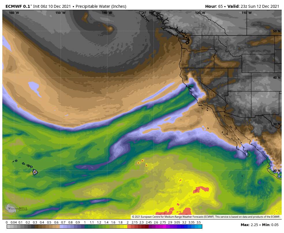
The majority of the models now show the Tahoe Basin someplace within the moisture plume streaming into the Sierra Sunday into Sunday night. That is boosting the snowfall amounts forecast for the first half of the storm and storm totals.
The winds will be gusting to over 100 mph over the top ridges Sunday into Sunday night. Highs in the 30s at the base and 20s for the upper mountain. Snow levels will fluctuate a little with the incoming surges of moisture and then fall, but still look to stay below the base through the storm.
By Monday morning we could have around 1-2 feet of snow at the base and 2 – 2.5+ feet of snow on the mountain.
Monday – Monday Night:
The heavy snow is expected to continue Monday into Monday night. So will the strong ridgetop winds up to 120+ mph. Highs still in the 30s at the base and 20s for the upper mountain. A front will bring reinforcement of heavy snowfall rates and then as the low off the coast moves inland Monday night we could see some of the heaviest snow of the storm along with falling snow levels and rising snow:liquid ratios.
We could see an additional 1.5-2 feet of snow at the base by Tuesday morning, and 2-3+ feet on the mountain.
Tuesday:
Behind the front on Tuesday colder air pushes in and snow showers may continue through most of the day, especially over the mountain as the cold air is lifted and the atmosphere is still unstable. But generally lighter snowfall than what we saw for 48 hours. Then we should taper off by Tuesday evening and clear briefly Tuesday night.
Highs for Tuesday may only be in the 20s at the base and teens up top. The strong winds will also finally fall off. That will finish out the storm with fluffy powdery snow with high snow:liquid ratios.
We could finish with a final 6-12 inches at the base and 1-2+ feet on the mountain. That would be potential 3-day storm totals of 3-5 feet at the base and 5 – 7.5+ feet on the mountain!
Wednesday – Thursday Storm:
Yesterday the majority of the forecast models had the next storm dropping south off of the CA coast and mostly missing the northern Sierra. Then stalling off the southern CA coast before moving inland next Sunday to our south and missing us again.
This morning the majority of the forecast models have shifted the track to the east, close enough for snow showers Wednesday and Thursday, and maybe some heavier snow for Wednesday night. This would be a cold storm so the snow:liquid ratios would be high and would help to boost potential snowfall amounts and the snow would be powdery.
It’s still a little too early to look at specific snowfall amounts, so keep an eye on our mountain forecast pages. We have to watch the trend on the track of this system. If it drops down off the coast we could be missed, if it drops down over the Sierra we could see up to 1-2 feet of powder. So stay tuned as we get closer.
Next Weekend:
For now, the forecast models have a dry forecast from next Friday through the weekend of the 18th-19th. But it should stay cold. I’m not sure if the mountain will still need to make any snow after the storms next week, but they will be able to if need be.
Long-Range:
The long-range models keep us in a new pattern into the last week of December. We may only have chances for weaker systems up to at least Christmas. We could see storms, if they track down from the north we just need them close enough to the ocean to tap into enough moisture to bring us accumulating snowfall.
The trough looks to stay in the West, for now, so not expecting any big warmups over the next 2 weeks. Hopefully, we’ll see a couple of more storms leading up to the holidays. We’ll keep an eye on it.
BA


