Palisades Tahoe Logo Palisades Tahoe Logo Palisades Tahoe Logo
Explore
  • Explore Palisades Tahoe
  • Our New Name
  • Explore Legendary Lifts
  • Palisades Tahoe Blog
  • About Lake Tahoe
  • About Us
Plan Your Visit
  • Tickets & Passes
  • Lodging
  • Lessons & Guides
  • Deals & Packages
  • Rentals & Demos
  • Travel Here
  • Getting Around
Mountain Information
  • Snow and Weather
  • Lift and Grooming Status
  • Webcams
  • Hours of Operation
  • Trail Maps
  • Parking & Road Conditions
  • Snowfall Tracker
Events & Activities
  • Events Calendar
  • Activities
  • Dining & Apres
  • Shopping
  • Things To Do In Lake Tahoe
  • Groups, Meetings & Weddings
  • Ski & Snowboard Teams
IKON PASS HOLDER LODGING DISCOUNT

Ikon Pass holders save up to 25% on slopeside lodging at The Village at Palisades Tahoe.

SLOPESIDE LODGING
Icon / FlashCreated with Sketch.
View All Offers
  • Weather

2+ Feet Since Thursday, More Snow Sunday into Monday

  • Feb 14, 2021
  • 7:55 am

Snowfall Report:

The snow showers Saturday dropped an additional 4-5 inches on the mountain. That brings the 2-day storm total to 10 inches on the upper mountain and the 3-day total to 24-26 inches! The season total is now at 221-223 inches.

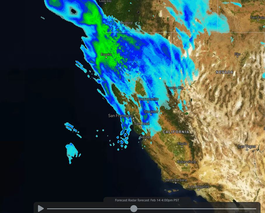
Sunday – Monday Storm:

Clouds & sun Sunday morning with increasing clouds into the afternoon. Highs in the 30s on the mountain. Winds could pick up some in the afternoon with ridgetop gusts up to 40+ mph by the end of the day. Light snow showers could move in Sunday afternoon.

We start as snow at the base Sunday night but then turning to rain after midnight as steadier precipitation and warmer air pushes in. Snow levels rising to around 6500-7000 ft. by Monday morning and possibly sitting in that range through most of the day Monday and not falling until the system ends Monday evening.

This storm will also bring gusty winds for Monday with ridgetop gusts of 70-80+ mph from the southwest, likely affecting some of the upper mountain lift operations Monday. Highs in the 30s. We could see an additional 0-2 inches of snow at the base with some of that coming before a change to rain Sunday night and maybe a coating at the end Monday afternoon/evening. 3-7 inches of new snow is possible on the mountain by Monday evening.

Tuesday – Wednesday:

Expecting mostly sunny skies for Tuesday – Wednesday, but the winds up top could still be gusting with northwest winds possibly gusting 40-50+ mph Tuesday and turning northeast for Wednesday gusting 50-60+ mph. Highs in the 30s both days.

Thursday – Friday System:

We may see increasing clouds Thursday ahead of another storm that is expected to move in by later Thursday into Friday. We could see snow Thursday night into Friday morning, with showers possibly lingering into Friday afternoon before clearing out Friday night.

Initial snowfall estimates are for 1-3 inches at the base and 3-6 inches on the mountain through Friday afternoon.

Long-Range:

High-pressure building in near the CA coast next weekend may bump the storm track to our north. We may see drier weather with highs in the 30s & 40s. 

That drier pattern may continue into the week of the 22nd with highs warming into the 50s. But then the pattern may shift the last few days of the month with an active storm track returning.

BA

lake tahoe weather snowfall forecast Squaw Weather Forecast
Bryan Allegretto
Bryan Allegretto

Share this article:

Recent Posts

  • Weather ·
  • May 26, 2022·

Colder with Unsettled Weather for Memorial Day Weekend

It’s the last weekend of the season and we could see a few flakes fall on the mountain! Thursday –…
Read more
  • Weather ·
  • May 17, 2022·

Quick Cooldown Thu-Fri, Then Milder Weather

A cool trough moves through Thursday – Friday. Highs dip down into the 60s at the base Thursday and 50s…
Read more
  • Weather ·
  • May 11, 2022·

After 15″ of Snow, A Return to Spring

Snowfall Report: We have had a cold and wintry first half of the week with several systems that rotated through…
Read more

Social

Instagram Twitter Facebook Youtube

Contact

   Email Us
   1.800.403.0206

Our Partners

U.S. Forest Service Logo
1960 Squaw Valley Road
Olympic Valley, CA 96146

©2022 Palisades Tahoe

Alterra Mountain Company
  • Privacy Policy
  • Terms of Service
  • Photo Upload Terms of Use
  • Accessibility
Menu
  • Privacy Policy
  • Terms of Service
  • Photo Upload Terms of Use
  • Accessibility