Today’s Operations (January 18, 2017)
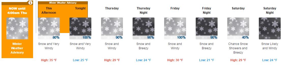
The first of the three part storm series moved in this morning, bringing high winds and precipitation that started as rain and transitioned to snow around 11am. It has been snowing consistently since then! As the day started, wind gusts on the crests clocked in upwards of 60mph and increased throughout the day to 80-90mph. Due to these extremely windy conditions, several lifts were put on wind hold or wind closure.
Check out NOAA Wind Sensors to see how wind speeds and wind gusts increased over the course of the day:


Several FEET of new SNOW by Monday

Storm 1
- Light rain and snow moves in today by afternoon. The snow levels start high this morning and fall to the base by this evening. We could see an inch or two on the mountain.
- Then heavier snow moves in tonight and then tapers off by Thursday afternoon. We could see 15-19 inches at the base and 16-25 inches on the mountain by Thursday afternoon.
- Thursday afternoon and evening we may see a break before the next storm moves in after midnight.
Storm 2
- Then heavy snow Friday. Friday night the snow turns to showers and then tapers off by Saturday morning. We could see additional snowfall of 11-15 inches at the base, and 13-21 inches on the mountain.
- We could see another break Saturday afternoon and evening before another storm moves in after midnight.
Storm 3
- Then heavy snow Sunday and turning showery Sunday night. The snow showers may linger into Monday. By Monday afternoon we could have additional snowfall accumulations of 21-26 inches at the base, and 24-35 inches on the mountain.
- The winds will be strong gusting up to 100 mph on the peaks through the period, so expect wind closures on upper lifts.
BA
Let’s Tally that Up…
When you combine these snow projections for the 3 storms, we could see 47-60 inches at the base and 53-81 up high by Monday. That’s nearly 7 FEET of new snow!
Operations for Tomorrow, January 19, 2017
Both mountains are geared up to get as many lifts as possible spinning for tomorrow’s powder day! Winds are forecasted to remain high, which may affect operations. As always, please stay tuned to our lift & trail status page and app for real-time information and updates. Here’s what’s on tap at both mountains:
Squaw Valley
With anticipated snow safety work tomorrow morning, Squaw Valley is preparing for the following lifts opening tomorrow:
At 9am
- KT-22
- Exhibition
- Far East
- Red Dog
- Squaw Creek
- Wylee
- Boon
- Firstventure Lift
- Tucker
- Snowventures Carpet
At 10am
- Funitel
- Gold Coast
- Shirley Lake
All other Squaw Valley lift opening times will be assessed and updated in the morning. Please check our lift & trail status and app in the morning for real-time status and updates.
Alpine Meadows
Alpine Meadows Ski Patrol is preparing for significant snow safety tomorrow including possible control work on the Alpine Meadows Road. This could result in a road closure while our crews ensure safety. Check our app, website, and twitter feed for real-time updates. The following lifts are scheduled for 9am tomorrow:
- Summit
- Roundhouse
- Hot Wheels
- Sherwood
- Meadow
- Yellow
- Scott
- Kangaroo
- Subway
- Lakeview
- Big Carpet
- Little Carpet
#januBURIED
With 15 feet of new snow so far and plenty more on the way, we are excited to see how much snow will pile up during this historic January! Be sure to share your snow-filled experiences using #januBURIED on Instagram and Twitter!