Today’s Overview, February 2, 2017
Today we experienced very high winds at both mountains as the storm moved in. With wind gusts over 70mph, upper mountain lifts at Squaw Valley and Alpine Meadows were put on wind hold or wind closure. Check out NOAA’s wind sensors:
Stormy Weather Continues

NOAA Weather forecast for Olympic Valley as of 3:30pm February 2
NOAA Forecast
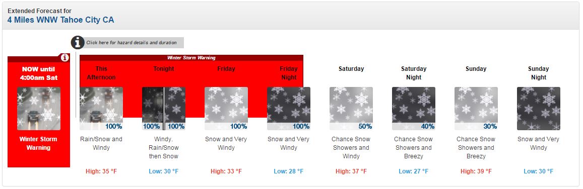
Stormy and dynamic weather is expected to stick around for the next few days. High wind gusts are expected and snow levels will vary. Check out the NOAA’s weather forecast:
- Tonight: Rain and snow, becoming all snow after 11pm. Low around 30. Windy, with a south wind around 30 mph, with gusts as high as 45 mph. Chance of precipitation is 100%. New snow accumulation of 3 to 5 inches possible.
- Tomorrow: Snow. Low around 28. Very windy, with a southwest wind 30 to 40 mph, with gusts as high as 60 mph. Chance of precipitation is 100%. New snow accumulation of 4 to 8 inches possible.
- Friday Night: Snow. Low around 28. Very windy, with a southwest wind 30 to 40 mph, with gusts as high as 60 mph. Chance of precipitation is 100%. New snow accumulation of 4 to 8 inches possible.
- Saturday: A 50 percent chance of snow showers. Mostly cloudy, with a high near 37. Windy, with a southwest wind 25 to 30 mph, with gusts as high as 45 mph. New snow accumulation of around an inch possible.
- Saturday Night: A 40 percent chance of snow showers. Mostly cloudy, with a low around 27. Breezy. New snow accumulation of less than a half inch possible.
- Sunday: A 30 percent chance of snow showers. Mostly cloudy, with a high near 39. Breezy. New snow accumulation of less than one inch possible.
- Sunday Night: Snow. Mostly cloudy, with a low around 30. Very windy.

NOAA Winter Storm Warning
NOAA has issued a Winter Storm Warning, updated 1:09pm February 2:
- TIMING: Moderate to heavy snow will pick up again late tonight through Friday.
- SNOW ACCUMULATIONS: An additional 1 to 2 feet above 7000 feet. Highest along the Sierra Crest. With 6 to 12 inches from 6500 to 7000 feet and up to 4 inches down to Lake Level.
- WINDS: South to Southwest 10 to 20 with gusts to 45 mph. Ridge gusts up to 100mph.
- SNOW LEVELS: Around 7000 feet this afternoon. Snow levels will fall to around 6500 feet Friday, then possibly to Lake Level Friday night.
- IMPACTS: Snow covered raods and low visibility will impact travel across Sierra passes late tonight and Friday.
Operations for Tomorrow, February 3, 2017
According to NOAA Weather Discussion, “Sierra ridges will gust up to 100 mph with the strongest gusts expected Friday and Friday night.” With this forecast in mind, wind holds on upper mountain at both Squaw Valley and Alpine Meadows are likely tomorrow. As always, operations are subject to weather and conditions. Our operations crews will assess conditions in the morning, so please check our app and lift status page for updates.