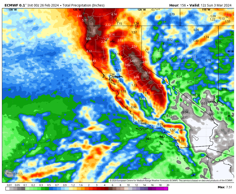
All attention this week will be on the very strong storm possible for Thursday-Saturday, possibly the biggest 3-day snowfall in over 3 years if the current forecasts hold. We’ll get to that in a minute after we deal with the weak system moving through Monday.
Monday System:
The latest trends with this system continue to be for the cold front to drop down farther to our east and the system off the CA coast moving in farther to our south, therefore the precipitation forecasts continue to drop.
We have ridgetop winds already gusting over 80+ mph for some mountains Monday morning, and they could peak at around 90-100+ mph from the west by afternoon. Highs in the 30s. We should see showers increase through the morning into the afternoon, and possibly lingering into the evening before diminishing overnight.
Snow levels look to start up around 6300-7300 ft. Monday morning, and only dropping to around 6000-7000 ft. by evening. Then dropping to around 5500-6000 ft. as showers wind down Monday night. That means low snow ratios for the mountains and some rain mixing in below 7000 ft. down to the base. We could see 0-2 inches of snow at the base by Tuesday morning, and 1-4 inches on the mountain.
Tuesday – Wednesday:
Clearing for Tuesday with mostly sunny skies into Wednesday. Highs into the 30s for the upper mountains and 40s for the lower elevations near the base. The winds drop on Tuesday with lighter winds into Wednesday.
Thursday – Saturday Storm:
I have been talking about the high precipitation amounts and feet of snow possible, but have been hesitant to get into details as the forecasts look huge and I didn’t want to get everyone overly hyped up more than 4-5 days ahead of the storm. That changes today as the start of the storm is only 3 days away and the models continue to be consistent and in agreement.
The snow is expected to move in Thursday with heavy snow Thursday night through Friday night and snow showers into Saturday night. Very strong winds are expected for Thursday and Friday so don’t plan to ski the upper mountain as quite a few lifts will likely be closed. The winds look gusty for Saturday but slowly coming down through the day. Highs in the 30s Thursday, 20s for the upper mountains Friday, and then 20s down to the base Saturday.
The snow levels will start near the base Thursday morning around 6000-6500 ft. and may only lower to around 5000-5500 ft. by Friday afternoon as the storm taps into some subtropical moisture. But that should be cold enough for mainly all snow to the base. Then much colder air moves in Friday night to Saturday with snow levels dropping below 3000 ft.
Snow ratios will start lower, around 9-11:1 between 7000-8000 ft. Thursday, and 11-13:1 Friday. The strong winds will help to increase the density of the snow as well. Then Friday night into Saturday snow ratios jump to 18-20:1 with powdery snow to finish the storm. We could see 3-day totals by Sunday morning of 4-5 feet near the base, and 5-7 feet on the mountain!
Sunday Weather:
A few scattered snow showers are possible for Sunday and it will stay cold behind the cold storm. Partly sunny skies with highs in the 20s.
Long-Range Forecast:
The break in the storms could continue through Tuesday the 5th. The next trough and storm could dig into northern CA around the 6th.
Some models continue to show the mean trough positions over the West Coast into the 2nd week of March while others have the mean trough positions farther east. Both patterns would keep temperatures below average. The position of the trough would determine if any storms will take a wetter or drier track.
There is better agreement that a storm around the 11th could dig farther West picking up more moisture before moving into northern CA. We’ll continue to watch the trends on that. Until then, lots of snow to track this week!
BA


